
Hike Schedule
Join us for a hike! Registration required:
All hikes available to BTC members. Some hikes are open to non-members.
TIP: The calendar view displays up to 7 hikes on a day, but often there are more. Click “More events” to see them all.
Categories
- 29April 29, 2024

Spring Ephemerals Discovery Hike at Jackson Cove
https://hikesstaging.brucetrail.org/event/spring-ephemerals-discovery-hike-at-jackson-cove/Sorry, the registration cut-off time for this hike has been reached.Not a member? Click here to join today!Hosting Club: Peninsula
Location (Google Maps): Jackson’s Cove Road at the top of the hill just to the west of the trail. 44.939536, -81.133319. Map 37 Bruce Trail Reference Guide Ed. 31.
Hike Leader(s): Marg Glendon Click here to contact Hike Leader(s)
Pace: Leisurely, Medium
Terrain: Moderate
Distance: ~4 KMDescription
Spring Ephemerals are woodland flowers which emerge before the trees show their leaves. Although they appear fragile, Spring Ephemerals often develop a relationship with fungi to help draw the water and nutrients they need to thrive. They are an important early source of pollen and nectar for insects. Jeannine Kralt, botany enthusiast, will lead our Spring Ephemeral Discovery hike along the Bruce Trail near Jackson’s Cove and winds through the Mackie Nature Reserve. This “Walk-Stop-Talk” hike is a slow pace ~4 km and includes a little hill climbing over rocky and uneven terrain. Be prepared for up to 3 hours. What to bring: A light backpack to carry water, light lunch or snack. Optional: Camera, insect repellent and bug net may be useful. What to wear: Sturdy footwear. Weather can be unpredictable at this time of year – dress in layers. Note: There are no washroom facilities at this location. We may encounter poison ivy.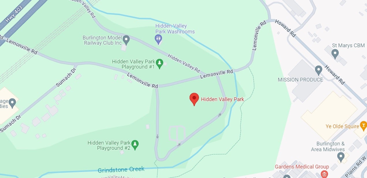
Hidden Valley to Hendrie Valley
https://hikesstaging.brucetrail.org/event/hidden-valley-to-hendrie-valley-2/Sorry, the registration cut-off time for this hike has been reached.Not a member? Click here to join today!Hosting Club: Iroquoia
Category: General Hike
Location (Google Maps): Meet at the parking lot at 1137 HIDDEN VALLEY ROAD -east side of Road -by the Hidden Valley Park washrooms(NOT the south lot off Lemonville Rd)Hike Leader(s): Cathie Green Click here to contact Hike Leader(s)
Pace: Medium – 3 to 4 km/hr
Terrain: Moderate – Some hills and/or some poor footing
Distance: Approximately 8 kmsDescription
We will follow a community trail from Hidden Valley Park in Burlington following Grindstone Creek to RBG Hendrie Valley where we will hike the Bridleand Grindstone Marsh Trails with some road walking to connect the trails
Lots of wildlife can be seen in this area -birds, deer, swans and wildflowers too
Spring like conditions-wet areas-dress for the weather, bring water, hiking poles, boots, lunch or snack. Call me or text me with any concerns, questions or last minute cancellation
Cathie Green 416-931-2095
Afternoon Hike - Kelso Summit (reservation required)
https://hikesstaging.brucetrail.org/event/afternoon-hike-kelso-summit-reservation-required/Sorry, the registration cut-off time for this hike has been reached.Not a member? Click here to join today!Hosting Club: Iroquoia
Category: Afternoon/Evening Hikes
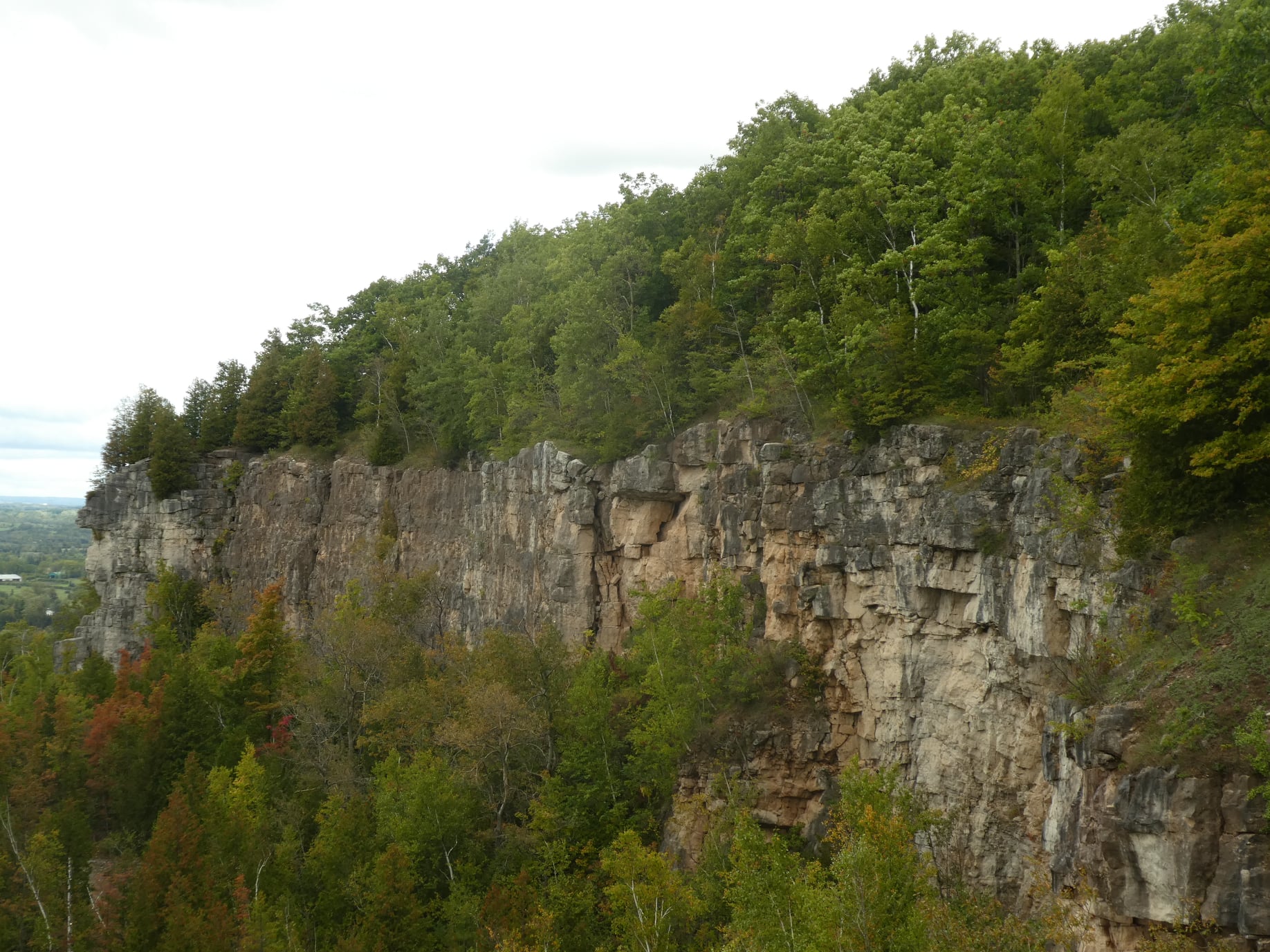
Location (Google Maps): Meet at 4:15 pm in the Kelso Summit parking lot on Steeles Ave.Hike Leader(s): Karen Bergmann Click here to contact Hike Leader(s)
Pace: Medium – 3 to 4 km/hr
Terrain: Moderate – Some hills and/or some poor footing
Distance: 7 kmsDescription
We will hike along a few of the trails in a loop. Please reserve your time at www.conservationhalton.ca - 30April 30, 2024
Peninsula in 6 Challenger Series B Hike #4 Richardson Side Trail to Dyers Bay
https://hikesstaging.brucetrail.org/event/peninsula-in-6-challenger-series-b-hike-4-richardson-side-trail-to-dyers-bay/Sorry, the registration cut-off time for this hike has been reached.Not a member? Click here to join today!Hike open to BTC Members only.
Hosting Club: Peninsula
Location (Google Maps):
Dyers Bay Community Parking
Capacity: 50
Coordinates: 45.162328, -81.340377Hike Leader(s): Margaret O’Dell Click here to contact Hike Leader(s)
Pace: Fast
Terrain: Difficult
Distance: 26 KmDescription
Hike #4 of 6 Richardson Side Trail to Dyers BayPeninsula in 6 Challenger Series
Complete 162.4 km section from Wiarton to Tobermory in 6 hikes.- You must sign up for EACH hike individually. The series is spread-out over 2 weeks, and 3 weekends. You are not automatically accepted into either series as a whole.
- This hike series is intended for experienced distance hikers only. Hikers must demonstrate recent experience completing hikes exceeding 25 km over difficult terrain and at a brisk pace;
- If a hiker is unable to keep pace with the group, or finds the distance too challenging, their future hike registrations may be canceled by the hike leader.
- Be very aware of your ability to join this series.
- Hikes will average 4.5 km per hour including breaks, moving pace is 5 km per hour;
- Expect to be on-trail for 7 – 9 hours;
- Meeting time is scheduled for 7:00am; arrive no later than 15 minutes prior to the meeting time;
- Hikers must carry sufficient hydration, accessible snacks, lunch, first-aid kit, rain gear, extra socks, and possibly protective boot covers (i.e. bags);
- Hikers will be expected to participate in shuttling hikers to the start and to drive shuttlers back to their car. Responsibility will be shared equally;
- Any applicable parking fees will be shared within the group.
Urban Walk: Valley View and Maple view Parks Thornhill
https://hikesstaging.brucetrail.org/event/urban-walk-valley-view-and-maple-view-parks-thornhill-4/Sorry, the registration cut-off time for this hike has been reached.Not a member? Click here to join today!Hosting Club: Toronto
Location (Google Maps): Parking lot at the corner of Bayview Ave, and Sycamore Dr. South of Highway 7
Sycamore Dr. is 2 blocks south of highway 7,parking lot is across plaza of Dollarama and Star boxHike Leader(s): Mohammad Aghamiri Click here to contact Hike Leader(s)
Pace: Moderate
Terrain: Variable
Distance: 7-8 kmDescription
We will explore Valleyview and Maple view parks, and walk along German Mill Creek,9:00 Long Hike Wiley Road Short Hills
https://hikesstaging.brucetrail.org/event/900-long-hike-wiley-road-short-hills-32/Sorry, the registration cut-off time for this hike has been reached.Not a member? Click here to join today!Hosting Club: Niagara
Location (Google Maps):
Short Hills Wiley Road Entrance
Pace: Medium
Terrain: Moderate
: 10kmDescription
Explore Short Hills and the majestic side trails of Scarlett Tanager, Hemlock. Swayze Falls and Terrace. Register for each hike
Bring Poles water, snack, and dress for the weather
9:15 Short Hike - Rotary Park
https://hikesstaging.brucetrail.org/event/915-short-hike-rotary-park-14/Sorry, the registration cut-off time for this hike has been reached.Not a member? Click here to join today!Hosting Club: Niagara
Category: Hike
Location (Google Maps): Rotary Park, 376 Regional Rd 69, St. CatharinesHike Leader(s): Debbie Demizio Click here to contact Hike Leader(s)
Pace: Medium
Terrain: Moderate
Distance: ~ 6kmsDescription
Hike around Twelve Mile Creek. Bring hiking boots, water, sunscreen and bug spray.Scotsdale Farm and Indigenous Village, Forest Bathing
https://hikesstaging.brucetrail.org/event/scotsdale-farm-and-indigenous-village-forest-bathing/Sorry, the registration cut-off time for this hike has been reached.Not a member? Click here to join today!Hosting Club: Dufferin Hi-Land
Category: Tuesday Hike
Location (Google Maps): Toronto Section, Map 13. Meet at Scotsdale Farm parking lot off of Trafalgar Rd (north of Km 29.8)Hike Leader(s): Janice McClelland;Les Babbage Click here to contact Hike Leader(s)
Pace: Leisurely
Terrain: Moderate
Distance: Long Hike: 8 km, Short Hike: 5.8 kmDescription
April/30/ 2024, 9:30 am – 1:00 pm –We will quietly hike the Bennet Heritage Trail, crossing Snows Creek pond and then Owl Creek, close to the site of the an Indigenous (Attiwonderonk) village from 1550-80. We will share info about the village. Our hike follows Owl Creek with a scenic break spot. Long hike will return via the Maureen Smith Side Trail and then the Main Trail – the short hike will return directly to the parking lot via the Bennet Side Trail. Please bring water and a lunch.
60 for the 60th Anniversary Badge Hike Series - #3 of 10
https://hikesstaging.brucetrail.org/event/60-for-the-60th-anniversary-badge-hike-series-3-of-10/Sorry, the registration cut-off time for this hike has been reached.Not a member? Click here to join today!Hosting Club: Caledon Hills
Category: General
Location (Google Maps): Parking area north of km 51.8, Map 18, on the east side of the 5th Line EHS, just south of Hockley Rd. on the BTC’s Hemlock Ridges Nature Reserve.Hike Leader(s): Joyce Redford 416-988-8753 Click here to contact Hike Leader(s)
Pace: Leisurely – 3 km/hour or less
Terrain: Moderate – some hills and/or some poor footing
Distance: 6 kmDescription
Join Joyce, Louise, and Marilyn on this 2 hour, 6 km hike which is the 3rd in the series of hikes for the new “60 for the 60th Anniversary” badge. We will hike southeast toward Airport Rd. and back. Hike one, a few, or all 10 hikes. Join any hike and make up the rest on your own as long as a record is kept of their hikes to submit on completion to obtain their badge. Participants who complete all 10 hikes will be eligible to purchase the “60 for the 60th” badge.
Bring poles, and hydration. - 01May 1, 2024
Peninsula in 6 Challenger Series B Hike #5 Dyers Bay to Halfway Dump
https://hikesstaging.brucetrail.org/event/peninsula-in-6-challenger-series-b-hike-5-dyers-bay-to-halfway-dump/Sorry, the registration cut-off time for this hike has been reached.Not a member? Click here to join today!Hike open to BTC Members only.
Hosting Club: Peninsula
Location (Google Maps):
Halfway Dump Side Trail via Emmett Lake Road
Fee by Park
Capacity: 50
Coordinates: 45.227342, -81.480393Hike Leader(s): Margaret O’Dell Click here to contact Hike Leader(s)
Pace: Fast
Terrain: Difficult
Distance: 27.4 KmDescription
Hike #5 of 6 Dyers Bay to Halfway Log DumpPeninsula in 6 Challenger Series
Complete 162.4 km section from Wiarton to Tobermory in 6 hikes.- You must sign up for EACH hike individually. The series is spread-out over 2 weeks, and 3 weekends. You are not automatically accepted into either series as a whole.
- This hike series is intended for experienced distance hikers only. Hikers must demonstrate recent experience completing hikes exceeding 25 km over difficult terrain and at a brisk pace;
- If a hiker is unable to keep pace with the group, or finds the distance too challenging, their future hike registrations may be canceled by the hike leader.
- Be very aware of your ability to join this series.
- Hikes will average 4.5 km per hour including breaks, moving pace is 5 km per hour;
- Expect to be on-trail for 7 – 9 hours;
- Meeting time is scheduled for 7:00am; arrive no later than 15 minutes prior to the meeting time;
- Hikers must carry sufficient hydration, accessible snacks, lunch, first-aid kit, rain gear, extra socks, and possibly protective boot covers (i.e. bags);
- Hikers will be expected to participate in shuttling hikers to the start and to drive shuttlers back to their car. Responsibility will be shared equally;
- Any applicable parking fees will be shared within the group.
Noisy River
https://hikesstaging.brucetrail.org/event/noisy-river/Sorry, the registration cut-off time for this hike has been reached.Not a member? Click here to join today!Hosting Club: Blue Mountains
Category: Register in person the morning of hike.
Location (Google Maps): Hike meets in the parking lot behind Tim Hortons on First St. in Collingwood.Hike Leader(s): Mary-Lynne Chenard Click here to contact Hike Leader(s)
Pace: Medium – 3 to 4 km/hr
Terrain: Moderate – Some hills and/or some poor footing
Distance: 13 kmDescription
We will park at Lavender Cemetery roadside parking about 0.5 km east of
Lavender Hill Road on Mulmur-Nottawasaga Townline. We begin hiking from the
cemetery over to the start of the Blue Mountains section, up to County Road 9 and
back. This hike offers a variety of terrain as we travel along crevices and through forest
and fields at times following alongside the Noisy River and a beautiful wetland. Bring a
snack or lunch and water.WEDNESDAY WALKERS - Start at the Very Beginning (of BV)
https://hikesstaging.brucetrail.org/event/wednesday-walkers-start-at-the-very-beginning-of-bv-2/Sorry, the registration cut-off time for this hike has been reached.Not a member? Click here to join today!Hosting Club: Beaver Valley
Location (Google Maps): Park at the end of Maple Lane at BV Km 0.0, Map 24, Edition 31
Hike Leader(s): Margaret Yaraskavitch Click here to contact the hike leader.
Pace: Medium
Terrain: Easy
Length of Hike: 5.0 kmDescription
This hike will be a there-and-back walk. Views from the edge of the Escarpment will show Collingwood and Nottawasaga Bay. We’ll pass Craigleith Ski Club and head towards a deep valley but then it is time to return. Often, views look different when walking in the opposite direction, promising another chance to experience wide open views of the shores of Nottawasaga Bay. Please bring water and a snackCOVID-19 Precautions Before, During and After your Hike
- Each hiker joining a Bruce Trail Club organized hike must perform a self-screening check before hiking.
Find Ontario’s self-assessment tool here: https://covid-19.ontario.ca/self-assessment/ - If you are experiencing COVID-19 symptoms, stay home.
Other Guidelines
- Arrive 15 minutes before the start of the hike.
- Wear sturdy footwear and appropriate attire for the weather and the terrain.
Hiking poles are a good idea in any season, especially if the terrain is rocky or slippery. In winter, snowshoes or icers/crampons are needed when conditions dictate.
Wearing appropriate clothing and footwear prevents injuries and shows consideration for a safe and positive group hiking experience. - Always carry I.D. and your health card.
- Bring sufficient water and snacks (or lunch if indicated). A minimum of 1L of water is recommended on all hikes, and 3L is recommended for long, challenging hikes in the heat of the summer.
- Bring sunscreen and insect repellent (for spring and summer hikes).
- Bring your own first aid kit.
- Please leave dogs at home.

Car Hike: Spring Ephemerals Hike In Terra Cotta Conservation Area
https://hikesstaging.brucetrail.org/event/car-hike-spring-ephemerals-hike-in-terra-cotta-conservation-area/Sorry, the registration cut-off time for this hike has been reached.Not a member? Click here to join today!Hosting Club: Toronto
Category: Car Hike
Location (Google Maps): Terra Cotta Conservation Area Winston Churchill Blvd. North of the King Rd
Parking on the side of the road where the Caledon Rail Trail crosses Winston Churchill Blvd.Hike Leader(s): Patricia Lynn McFerran Click here to contact Hike Leader(s)
Pace: Leisurely
Terrain: Variable
Distance: 8-10kmDescription
This leisurely hike through the conservation area will give us an opportunity to see a variety of spring wild flowers and other local flora. Maybe even a few invasive species.
If you are interested in starting to collect the requirements for your TBTC Biodiversity Naturalist badge this is a great way to get going. There’s lots to see along the trails. The terrain shifts as we walk through the area and so do the plants we will see. Download I naturalist , Merlin or Seek on your phone to help with identification. There are some interesting sites within the conservation area too, including old brick works, a sugar shack, and a waterfall.
Please dress for the weather, this is a rain or shine hike but I am hoping for sunshine!
Bring your camera or phones, snacks, water, sunscreen and bug spray You never know what the the beginning of May will bring.
Niagara Glen Short and Sassy
https://hikesstaging.brucetrail.org/event/niagara-glen-short-and-sassy-2/Sorry, the registration cut-off time for this hike has been reached.Not a member? Click here to join today!Hosting Club: Iroquoia
Category: Good Companions
Location (Google Maps):Niagara Glen, 3050 Niagara Parkway, Niagara-on-the-Lake, ON
Hike Leader(s): Craig Sim Click here to contact Hike Leader(s)
Pace: Medium – 3 to 4 km/hr
Terrain: Moderate – Some hills and/or some poor footing
Distance: 6-7k (approximate)Description
Loop hike in beautiful Niagara Glen, NOT using Whirlpool Trail. We meet in between Niagara Glen parking lot and building near lot. Pay parking or Niagara parks pass. Trail ranges from moderate to quite rocky, has hills and stairs. Watch footing. Lots of boulders and great views close to Niagara River. We descend steel stairs before and after hike. Wear hiking boots or shoes. Bring water, snack, appropriate layered clothing for the weather and rain gear. Optional beverage/food after. Niagara Glen is close to both Butterfly Conservatory and Floral Clock.Evening Hike in Owen Sound followed by an Opportunity for Refreshments
https://hikesstaging.brucetrail.org/event/evening-hike-in-owen-sound-followed-by-an-opportunity-for-refreshments-5/Sorry, the registration cut-off time for this hike has been reached.Not a member? Click here to join today!Hosting Club: Sydenham
Category: An evening walk.
Location (Google Maps): First Ave East parking lot between 8th St East and 7th St East. Owen SoundHike Leader(s): Harriet Nixon Click here to contact Hike Leader(s)
Pace: Brisk: 4 to 5 km/h
Terrain: Easy: Mostly flat and good footing.Description
Join us for an evening hike exploring Owen Sound paths and neighbourhoods, followed by an opportunity for refreshments. There is no need to arrive 15 minutes early, but this hike will start promptly at 7:00 pm. - 02May 2, 2024
Peninsula in 6 Challenger Series B Hike #6 Halfway Dump to Peninsula Terminus
https://hikesstaging.brucetrail.org/event/peninsula-in-6-challenger-series-b-hike-6-halfway-dump-to-peninsula-terminus/Sorry, the registration cut-off time for this hike has been reached.Not a member? Click here to join today!Hike open to BTC Members only.
Hosting Club: Peninsula
Location (Google Maps):
Peninsula Terminus 45.236000, -81.594000
Street Parking availableHike Leader(s): Margaret O’Dell Click here to contact Hike Leader(s)
Pace: Fast
Terrain: Difficult
Distance: 25.2 KmDescription
Hike #6 of 6 Halfway Log Dump to Peninsula TerminusPeninsula in 6 Challenger Series
Complete 162.4 km section from Wiarton to Tobermory in 6 hikes.- You must sign up for EACH hike individually. The series is spread-out over 2 weeks, and 3 weekends. You are not automatically accepted into either series as a whole.
- This hike series is intended for experienced distance hikers only. Hikers must demonstrate recent experience completing hikes exceeding 25 km over difficult terrain and at a brisk pace;
- If a hiker is unable to keep pace with the group, or finds the distance too challenging, their future hike registrations may be canceled by the hike leader.
- Be very aware of your ability to join this series.
- Hikes will average 4.5 km per hour including breaks, moving pace is 5 km per hour;
- Expect to be on-trail for 7 – 9 hours;
- Meeting time is scheduled for 7:00am; arrive no later than 15 minutes prior to the meeting time;
- Hikers must carry sufficient hydration, accessible snacks, lunch, first-aid kit, rain gear, extra socks, and possibly protective boot covers (i.e. bags);
- Hikers will be expected to participate in shuttling hikers to the start and to drive shuttlers back to their car. Responsibility will be shared equally;
- Any applicable parking fees will be shared within the group.

Car Hike: Dufferin fundraiser, 4 hikes. Stained Glass Badge
https://hikesstaging.brucetrail.org/event/dufferin-fundraiser-4-hikes-stained-glass-badge/Sorry, the registration cut-off time for this hike has been reached.Not a member? Click here to join today!Hike open to BTC Members only.
This is a Multi-Day Hike
You are signing up for the following dates and times:
2024-05-02 at 08:30
2024-05-03 at 08:30
2024-05-09 at 08:30
2024-05-10 at 08:30Hosting Club: Toronto, Dufferin Hi-Land
Category: Car Hike
Location (Google Maps): Mono Community Centre, west of km 72.2 Caledon. Coordinates N 44.026195,W 80.071516Hike Leader(s): Smadar Junkin Click here to contact Hike Leader(s)
Pace: Brisk
Terrain: Hilly, Variable
Distance: 14.1 kmDescription
This is a fundraiser hiking series of 4 hikes. The funds will be collected by the Toronto Club and will be moved to the Dufferin Club. Registered hikers will earn the new Stain Glass Badge. The registration is for all 4 days. May 2, 3, 9, 10. The badges will be given by the hike leader on the last day.
you will be allowed to miss one hike. Please let the leader know before the day that you will be missing the hike, keep a log of the hike. It needs to be completed before the May 9, 2024.the hike is marked as BRISK- expected moving pace is 4.5 km per hours.
the fees will go to support the Dufferin Club which supports the the Bruce Trail Conservancy “ preserving a ribbon of wilderness for everyone for ever״.
At this hike the registration is limited to Bruce Trail Conservancy members.
hikers are expected to follow all Covid 19 guidelines and stay home if they have symptoms.
arrive 15 minutes early, bring 2 litres of water. We will have one break for snack/ lunch.
meeting points will be sent to the participants of these hikes. Everyone is expected to take part in the car shuttle.
Dufferin E2E Stained Glass Series in 4 Hikes
https://hikesstaging.brucetrail.org/event/dufferin-e2e-stained-glass-series-in-4-hikes/Sorry, the registration cut-off time for this hike has been reached.Not a member? Click here to join today!Hike open to BTC Members only.
This is a Multi-Day Hike
You are signing up for the following dates and times:
2024-05-02 at 08:45
2024-05-09 at
2024-05-16 at
2024-05-23 atHosting Club: Toronto, Dufferin Hi-Land
Category: Car Hike
Location (Google Maps): On Mulmur-Nottawasaga Townline, 550m east of Lavender Hill Rd., at the cemetery. Do NOT block cemetery gate. GPS N44.268777, W80.156810Hike Leader(s): Jacquie Van Dyke Click here to contact Hike Leader(s)
Pace: Moderate
Terrain: Hilly, Variable
Distance: 14kmDescription
This is an E2E Dufferin fundraiser Stained Glass series in 4 hikes. The hikes vary in distance 12 – 14km and will be hiked at a moderate pace. The funds will be collected by the Toronto Club and will be moved to the Dufferin Club. The registration date, beginning March 2 at 8:30am, will be for all hikes (May 2, 9, 16, 23). Hikers who qualify for the Stained Glass badge will received it from the hike leader at the end of the last hike. You can miss one hike but please let the hike leader know ahead of time and ensure it is made up before May 23.Hikers are expected to follow all Covid 19 guidelines and stay home if they have symptoms.
Please arrive at least 15 minutes early (by 8:30am) to ensure you’re organized and ready to leave at 8:45am. Please bring a minimum of 2L of water, enough food to last the hike, and bug repellent.
Everyone is expected to participate in the car shuttles.

Peninsula Bruce Trail Club: End-to-End 18-Day Hiking Series - Please read description before registering
https://hikesstaging.brucetrail.org/event/peninsula-bruce-trail-club-end-to-end-18-day-hiking-series/Sorry, the registration cut-off time for this hike has been reached.Not a member? Click here to join today!Hike open to BTC Members only.
This is a Multi-Day Hike
You are signing up for the following dates and times:
2024-05-02 at 09:00
2024-05-03 at 09:00
2024-05-16 at 09:00
2024-05-17 at 09:00
2024-05-30 at 09:00
2024-05-31 at 09:00
2024-06-13 at 09:00
2024-06-14 at 09:00
2024-06-27 at 09:00
2024-06-28 at 09:00
2024-09-05 at 09:00
2024-09-06 at 09:00
2024-09-19 at 09:00
2024-09-20 at 09:00
2024-10-04 at 09:00
2024-10-17 at 09:00
2024-10-18 at 09:00Hosting Club: Peninsula
Location (Google Maps): Hike 1 – Meeting Location – Wiarton Bluewater Park
Hike Leader(s): Various Click here to contact Hike Leader(s)
Pace: Medium
Terrain: Difficult, Moderate
Distance: Varies by hikeDescription
Event Type: Multi-Day HikeOpen to Bruce Trail Conservancy (BTC) Members Only.
Non-members can join by signing up for a one-year BTC membership [$75] before registering at Bruce Trail Conservancy Memberships.
Participant Limit: Maximum of 30 participants, including the hike leader and sweep(s).
Scheduled Dates:
- May 2, 3, 16, 17, 30, 31, 2024
- June 13, 14, 27, 28, 2024
- September 5, 6, 19, 20, 2024
- October 3, 4, 17, 18, 2024
Registration Fees:
- BTC Members: $200
- Includes Bus Shuttle, Bruce Peninsula National Park (BPNP) Fees, and Badge Fee
- To Confirm Your Registration E-transfer $200 to HikeWithPBTC@gmail.com
- Note: No refunds, hiker substitutions, or guest hikers.
Hike Leadership:
- Led by PBTC Certified Hike Leader(s) and Sweep(s).
- Pace: Moderate/Medium
- Terrain: Moderate/Difficult
- Average Hike Distance: Approximately 8 – 12 KM per day, [one of the hikes is 14 KM]
Hike Overview:
- Complete the Peninsula section of the Bruce Trail over 18 hikes.
- Direction: Northbound from Wiarton to Tobermory.
- Group Hike Format: Participants commit to the entire series.
- Intermediate hikers comfortable with moderate challenges, including longer distances and elevation gains.
- Expected Pace: 3 km/hr over 8 – 12km, with the longest section being 14km.
- Total Distance: Approximately 165km with no dropout points.
- Time allocated for photography and appreciating the local flora and fauna.
Participant Requirements:
- Assess and ensure physical fitness for group hiking.
- Attire: Proper hiking boots, layered clothing for varying weather, and wet weather gear. Hiking poles recommended.
- Essentials: Sufficient food [lunch], snacks and water for a full day, bug spray.
- Breaks: Morning, 15-30 minute on-trail lunch, and afternoon breaks, weather-dependent.
- Participant is required to sign a BTC Waiver of Liability
Fee:
- Covers bus shuttle, BPNP fees, and badge fee.
- Surplus, if any, supports Peninsula Bruce Trail Club’s hike program
Transportation:
- Bus shuttle to trailhead and from end of hike, avoiding car shuttles.
- Typical Meeting Time: Around 9 AM, with return times varying based on daily hiking distance and bus schedule.
Environmental Responsibility:
- Adherence to Leave No Trace principles.
- Collective effort in trail cleanliness.
- Note: Dogs are not permitted on this hike.
Accommodations:
- Early reservations recommended.
- Suggested locations: Near meeting points or centrally in Lion’s Head.
- Options include motels, campgrounds, hostels, and B&Bs.
Schedule and Communication:
- Detailed itinerary sent prior to each two-day hike segment.
- Schedule subject to change.
Join us for this memorable hiking adventure and be part of a community dedicated to preserving and enjoying the natural beauty of the Bruce Trail.
9:00 am Long Hike Jordan to Moyer / Louth
https://hikesstaging.brucetrail.org/event/900-am-long-hike-jordan-to-moyer-louth-69/Sorry, the registration cut-off time for this hike has been reached.Not a member? Click here to join today!Hosting Club: Niagara
Location (Google Maps):
Jordan Hollow Park 3039 King St Jordan
Pace: Medium
Terrain: Moderate
: 10kDescription
From Jordan Hollow Hike the main trail to Upper and Lower Balls Falls, Moyer Road or Louth and Return. You must register for each hike. Bring Poles, sunscreen, bug spray , snack and a drink and dress for the weather
Beaver Valley End-to-End Hike 3 of 9
https://hikesstaging.brucetrail.org/event/beaver-valley-end-to-end-hike-3-of-9/Sorry, the registration cut-off time for this hike has been reached.Not a member? Click here to join today!Hosting Club: Caledon Hills
Category: End-to-End
Location (Google Maps): Meet at Windy Lane parking, km 78.5, Map 26 (Ed. 31) at the Beaver Valley Ski Club. Shuttle to start at Sideroad 19.Hike Leader(s): Nancy Mooney Click here to contact Hike Leader(s)
Pace: Medium – 3 to 4 km/hour
Terrain: Moderate – some hills and/or some poor footing, Strenuous – hilly with steep climbs and some poor footing
Distance: 92.3 – 78.5 = 13.8 km totalDescription
This is the third hike of the series and takes us along the top of Beaver Valley Ski hills on the west side of the valley. It includes Kimberley Springs Nature Reserve, views of Beaver Valley, Old Baldy, Kimberley Rock and Nottawasaga Bay.9:15 Short Hike, Jordan Hollow
https://hikesstaging.brucetrail.org/event/915-short-hike-jordan-hollow-108/Sorry, the registration cut-off time for this hike has been reached.Not a member? Click here to join today!Hosting Club: Niagara
Category: Hike
Location (Google Maps): Jordan Hollow Park, Jordan StationHike Leader(s): Bill Russell Click here to contact Hike Leader(s)
Pace: Medium
Terrain: Strenuous
Distance: ~ 6kmsDescription
Hike the main and side trails around Jordan and Balls Falls. Bring hiking boots, water, sunscreen and bug spray.
Borer’s Falls
https://hikesstaging.brucetrail.org/event/borers-falls/Sorry, the registration cut-off time for this hike has been reached.Not a member? Click here to join today!Hosting Club: Iroquoia
Category: Thursday Group
Location (Google Maps): Borer’s Dog Park on York RdHike Leader(s): Colleen Mabalay Click here to contact Hike Leader(s)
Pace: Medium – 3 to 4 km/hr
Terrain: Moderate – Some hills and/or some poor footing
Distance: 9kmDescription
From the dog park we will take the Ray Lowes ST to the main trail to make our way to RBG Rock Chapel. There is a steep hill and stairs to climb, and to descend on the return. Bring water & snacks.Neighbourhood hike: Beamsville/Ashby Park to Bruce Trail loop
https://hikesstaging.brucetrail.org/event/neighbourhood-hike-beamsville-ashby-park-to-bruce-trail-loop/Sorry, the registration cut-off time for this hike has been reached.Not a member? Click here to join today!Hosting Club: Niagara
Category: Loop
Location (Google Maps): Meet at Ashby Park
4079 Ashby Dr, Beamsville, ON L0R 1B6Hike Leader(s): Angela Lytle Click here to contact Hike Leader(s)
Pace: Medium
Terrain: ModerateDescription
Let’s take a local hike starting in a Beamsville neighbourhood after work or school!This neighbourhood loop hike starts in Beamsville’s local Ashby park, goes up Hillside trail (past the monarch way station), across Hillside and up Hixon to join the Bruce trail. From there we will hike east on the Bruce Trail towards Quarry road, and then loop back to Ashby park.
The pace of the hike will be moderate. The terrain is mixed with some paved paths, street and sidewalk, as well as the trail. There are some rocky sections of the trail.
Meet at 5:15 by the playground in the park to depart at 5:30. Limited street parking available next to the park, or walk if you live nearby! The full loop should take around 1.5 hours (max 2 hours) depending on our collective pace.
Hiking shoes are needed, poles are recommended. Carry water and some snacks.

Urban Walk: Toronto Islands Evening Walk
https://hikesstaging.brucetrail.org/event/urban-walk-toronto-islands-evening-walk/Sorry, the registration cut-off time for this hike has been reached.Not a member? Click here to join today!Hosting Club: Toronto
Category: Urban Walk
Location (Google Maps): Jack Layton Ferry Terminal, near the gates to Wards Island Ferry. Arrive 20 minutes prior to departure to check in with hike leader.From Union Station take the LRT and get off at the stop Ferry Docks.Walk up to the Ferry Docks on Queens Quay West, street level. at the foot of Bay Street.
Hike Leader(s): Miriam Stevens Click here to contact Hike Leader(s)
Pace: Leisurely
Terrain: Flat
Distance: 6-9 kmDescription
After a day’s work come and “cool off” on the Toronto Islands free of fumes and traffic. Enjoy the view of the city skyline and Toronto’s beautiful island parkland.
Pack a dinner for a sit down picnic. Food is not available for purchase on the Islands early in the season. Also bring a warm jacket and flashlight.
Return fare ticket for the ferry approx $10.00 less for seniors.
Hikes will take place rain or shine.
Toronto Island evening hikes will take place every THURSDAY in MAY and JUNE 2024.
Same time and same meeting place. No preregistration is required – just show up at the ferry docks at 5:40 PM and sign with the hike leader.