
Hike Schedule
Join us for a hike! Registration required:
All hikes available to BTC members. Some hikes are open to non-members.
TIP: The calendar view displays up to 7 hikes on a day, but often there are more. Click “More events” to see them all.
Categories
- 15June 15, 2024

Dufferin Hi-Lands End to End in 2 Hikes ~ Stained Glass Fundraiser Badge
https://hikesstaging.brucetrail.org/event/dufferin-hi-lands-end-to-end-in-2-hikes-stained-glass-fundraiser-badge/Sorry, the registration cut-off time for this hike has been reached.Not a member? Click here to join today!Hike open to BTC Members only.
This is a Multi-Day Hike
You are signing up for the following dates and times:
2024-06-15 at 07:00
2024-06-16 at 07:00Hosting Club: Dufferin Hi-Land, Sydenham
Category: Fundraiser
Location (Google Maps): Jun 15: Lavender Cemetery, Mulmur Nottawasaga Townline, Creemore, ON GPS Coordinates: 44.2689881 -80.1573367. Shuttle to Parking area on 1st Line E
Jun 16: Mono Community Centre, Mono Centre Road, Mono, ON; GPS Coordinates: 44.0270957 -80.0710983. Shuttle to Parking area on 1st Line EHike Leader(s): Margaret O’Dell Click here to contact Hike Leader(s)
Pace: Brisk: 4 to 5 km/h, Fast: more than 5 km/h
Terrain: Strenuous: Hilly with steep climbs and some poor footing.
Distance: Jun 15: 27 km; Jun 16 28.5 km;Description
This series of hikes is a Fundraiser for the Dufferin Hi-Land Bruce Trail Club. All proceeds fund the activities of the Club directly. You are signing up for 2 hikes, and must be present for both to receive the beautiful Stained Glass Lady Slippers End to End badge, included in your registrationWe will hike Northbound on Jun 15 from 1st Line E to Lavender Hill for 27.0 km. We will hike Southbound on Jun 16 from 1st Line E to Mono Centre for 28.5 Km. The GPS coordinates are provided for each day’s meeting location. This hike series is intended for experienced distance hikers only; hikes will be lead at a brisk to fast pace. Be aware of your ability to join this series.
- Hikes will average 4.5 km per hour including breaks, moving pace is 5 km per hour;
- Expect to be on-trail for 6-7 hours;
- Meeting time is scheduled for an early start at 7:00am so that we’re on the trail at the earliest part of the day and avoid the heat in the afternoons;
- You must arrive no later than 15 minutes prior to the meeting time to organize shuttle; all participants are expected to participate in the shuttle;
- Any applicable parking fees will be shared within the group.
- Hikers must carry sufficient hydration, accessible snacks, small lunch, first-aid kit, rain gear, extra socks, bug spray, etc; Check the weather as you pack your gear;
- If you have any questions or concerns, please use the Contact the Hike Leader above.
Bus Hike: Pretty River
https://hikesstaging.brucetrail.org/event/bus-hike-pretty-river-2/Sorry, the registration cut-off time for this hike has been reached.Not a member? Click here to join today!Trip Information
Departure Time: 08:00
Return to City Time: 18:15
Departure Point: York Mills Bus PickupOptional Items
Hosting Club: Toronto, Blue Mountains
Category: Bus Hike
Location (Google Maps): Pretty River Valley Provincial ParkHike Leader(s): Martina Furrer, Roland Mark, Michael Humpage and Ross Estrella Click here to contact Hike Leader(s)
Pace: Fast, Moderate
Terrain: Hilly
Distance: Fast (16 to 18 km), moderate (13 km)Description
Join us for a fun and challenging hike through Nottawasaga Lookout Provincial Nature Reserve and Pretty River Valley Provincial Park. Our efforts will be rewarded with great views and hopefully the forest floor will be dotted with wildflowers. From Osler Bluff and the Petun Side Trail we should have amazing views of Georgian Bay.We will split into two groups. The moderate group will do about 13 km at a pace of approximately 3 km/hr. The fast group will hike 16 to 18 km at a 4 km/hr pace (including on hills).
Pack lunch, water (about 2 litres), sun protection, rain protection, and bug protection.
Refreshment stop after if time allows.
Bus departs 10 York Mills Rd at 8 AM.
Car Hike: Hike of 2 lakes
https://hikesstaging.brucetrail.org/event/car-hike-hike-of-2-lakes/Sorry, the registration cut-off time for this hike has been reached.Not a member? Click here to join today!Hosting Club: Toronto
Category: Car Hike
Location (Google Maps): Park along Fairfield Dr. or Dufferin Street. Gather at trail head on Dufferin Street.Hike Leader(s): Mohammad Aghamiri
Pace: Moderate
Terrain: Variable
Distance: 14-17 kmDescription
We will hike in trails around Seneca lake and Mary Lake, pass by Eaton hall and visit Pine farm where you can enjoy coffee, tea, apple pie during our snack time.Some safety procedures during the hike:
1-Hikers must stay between the leader and the sweep.
2-Hikers must advise the leader or the sweep if they wish to leave the group.
3- Hikers must follow the whistle instructions: 1 blast- stay where you are; 2 blasts come to the leader; 3 blasts – come to the leader quickly.
4-Hike leader may request volunteers to stop at trail intersections, they need to help hikers to the direction the group walk and wait till they see the sweep .
5-Hikers have to make sure they can see the persons behind and in front of them.

Just For Fun - Hike Through Six BTC Protected Natural Areas
https://hikesstaging.brucetrail.org/event/just-for-fun-hike-through-six-btc-protected-natural-areas/Sorry, the registration cut-off time for this hike has been reached.Not a member? Click here to join today!Hosting Club: Caledon Hills
Category: General
Location (Google Maps): Meet at the Bruce Trail Parking Lot on Mono 5 Sideroad on the north side of the road where the Trail crosses. Google GPS Coordinates: 43.974055, -79.984988Directions: From Airport Road turn east onto 5 Sideroad and drive for 600 metres. The parking lot is on the left hand side.
Hike Leader(s): Sandy Green and Dylan “Lana” Hubbard Click here to contact Hike Leader(s)
Pace: Medium – 3 to 4 km/hour
Terrain: Moderate – some hills and/or some poor footing
Distance: 10 kilometresDescription
Hike through six Bruce Trail Conservancy protected natural areas in the south eastern area of Hockley Valley. Bring your choice of hydration and snacks. Sturdy footwear is highly recommended. This hike can be counted towards your 60 for the 60th Connecting People With Nature badge.Beaver Valley Geology Hikes Badge Hike #1/8
https://hikesstaging.brucetrail.org/event/beaver-valley-geology-hikes-badge-hike-1-8/Sorry, the registration cut-off time for this hike has been reached.Not a member? Click here to join today!This is a Multi-Day Hike
You are signing up for the following dates and times:
2024-06-15 at 09:00
2024-07-24 at 09:00
2024-08-14 at 09:00
2024-09-07 at 09:00
2024-09-18 at 09:00
2024-09-25 at 09:00
2024-10-02 at 09:00
2024-10-12 at 09:00Hosting Club: Blue Mountains
Category: Register online ONLY
Location (Google Maps): Hike meets in the parking lot behind Tim Hortons on First St. in Collingwood.Hike Leader(s): Annette Sandberg Click here to contact Hike Leader(s)
Pace: Medium – 3 to 4 km/hr
Terrain: Moderate – Some hills and/or some poor footing
Distance: 7.1 kmDescription
This badge is earned by hiking each of 8 hikes outlined in Beth Gilhespy’s first Bruce Trail Geology book, Walking Through Time, and then submitting a log which includes the required photo taken during each of the hikes. You can do the hikes with us, on your own, or a combination of both. This is a great opportunity to boost your knowledge of the geology of the Niagara Escarpment. Gather some hiking buddies and become rock hounds! Description: Len Gertier Memorial Loree Forest: Natural Arch at Stop 4 (page 43). Natural arches are created when water pounding against a cliff face exploits crack and crevices, gradually wearing the rock away. Natural arches can become flowerpots if erosion continues. Thousands of years ago, the level of the Great Lakes was significantly higher and lapped up against the promontory of Loree Forest.Easy Does it Hike
https://hikesstaging.brucetrail.org/event/easy-does-it-hike-2/Sorry, the registration cut-off time for this hike has been reached.Not a member? Click here to join today!Hosting Club: Niagara
Category: In and Out
Location (Google Maps): Easy Does it Hike, Park at McGarr Realty, 5 St. Paul St., St Catharines. We’ll walk in the area on city streets and local paths.Hike Leader(s): Diane Marlatt Click here to contact Hike Leader(s)
Pace: Leisurely
Terrain: Easy
Distance: 3kmDescription
Chi-Cheemaun Festival Hike in Tobermory
https://hikesstaging.brucetrail.org/event/chi-cheemaun-festival-hike-in-tobermory/Sorry, the registration cut-off time for this hike has been reached.Not a member? Click here to join today!Hosting Club: Peninsula
Location (Google Maps): Meet at Little Tub Harbour at the Peninsula Bruce Trail Club Tent in Tobermory
Hike Leader(s): Darci Lombard Click here to contact Hike Leader(s)
Pace: Medium
Terrain: Easy, Moderate
Distance: ~ 5 KM for entire hike. Or, ~2 KM for the shorter hike.Description
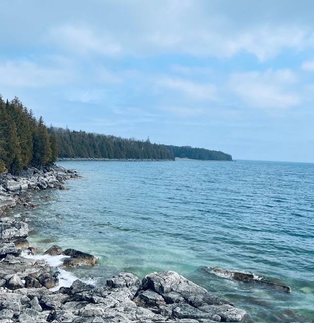
Join local PBTC hike leaders for a guided hike of the nearby Bruce Trail – both main trail and the Burnt Loop Sidetrail. Immerse yourself in the beauty of the cedar forest, as you witness the pretty waterviews of Little Dunks Bay and pretty vistas of Georgian Bay, Flower Pot Island, Bears Rump Island, and Middle Island. You will also pass the Bruce Peninsula National Park Visitor Centre – a must-see – if you are visiting Tobermory for the first time! And, don’t forget the iconic northern Bruce Trail Cairn – where the official opening of the Bruce Trail occurred in 1967. The main trail is wheelchair accessible to the first lookout on the Burnt Loop Access Trail. This hike is suitable for families with children 8 years and older. Here, you may choose to retrace your steps to the village on your own. Or, consider continuing with the hike leaders on the rest of Burnt Loop Sidetrail . If joining the hike for the entire Burnt Loop Sidetrail , be prepared for rocky and rooty terrain which requires good balance. Wear sturdy footwear and sun protective clothing. Bring a backpack to carry your waterbottle and a light snack. If hiking the full hiking route, be prepared for about a 3 hour hike. If hiking to the first lookout and back, this will take approximately 1 hour.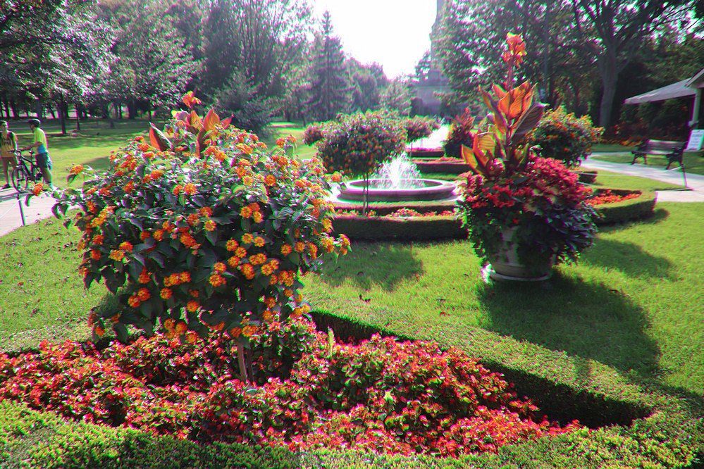
9:30 Queenston Heights Loop "NOTE NEW THEME AND ROUTE"
https://hikesstaging.brucetrail.org/event/930-roses-roses-roses-at-niagara-parks-botanical-gardens/Sorry, the registration cut-off time for this hike has been reached.Not a member? Click here to join today!Hosting Club: Niagara
Category: Loop
Location (Google Maps):Locust Grove Picnic Area
Hike Leader(s): Karen Couch Click here to contact Hike Leader(s)
Pace: Medium
Terrain: Moderate
Distance: 6-8 kmDescription
Hike the main trail and side trails, in and around Queenstown Heights while we enjoy the flowers that Niagara Parks has on display.Much of this hike is in the open, so participants are reminded to come prepared for the sun and heat (e.g., sunscreen, hat and water).
iNaturalist Summer Solstice Hike #2
https://hikesstaging.brucetrail.org/event/inaturalist-summer-solstice-hike-2/Sorry, the registration cut-off time for this hike has been reached.Not a member? Click here to join today!Hosting Club: Dufferin Hi-Land
Category: Special Events
Location (Google Maps): Meet at Prince of Wales and 15 Sideroad. Registration is not requiredHike Leader(s): Tom Thayer Click here to contact Hike Leader(s)
Pace: Leisurely
Terrain: Easy, Moderate
Distance: 6 kmsDescription
Registration is not required for this event. Please feel free to join us with or without registering.Join us for a hike through Pine River Nature Reserve and learn how to use the iNaturalist App to help the Bruce Trail protect endangered/at-risk species, monitor existing species, identify invasive species that need to be removed, and learn about the plans to enhance and enrich biodiversity.
Interact with the Bruce Trail Conservancy’s Conservation and Ecology specialists, meet some of our new trail ambassadors, and learn more about how the Dufferin Hi-Land Bruce Trail Club is working with the BTC to provide a sustainable and healthy future for generations to come.
Please Note: You will need a mobile device with the iNaturalist App installed and updated in order to take part in this event. You can download the app from the App Store or Google Play Store. More information about the iNaturalist program is available here: https://development.brucetrail.org/what-we-do/#iNaturalist
Everyone is welcome, member and non-member alike.

Toronto Urban Badge Hike - 7 of 7
https://hikesstaging.brucetrail.org/event/toronto-urban-badge-hike-7-of-7-4/Sorry, the registration cut-off time for this hike has been reached.Not a member? Click here to join today!Hosting Club: Toronto
Location (Google Maps):
Toronto
Hike Leader(s): Brian Rideout Click here to contact Hike Leader(s)
Pace: Moderate
Terrain: Flat
Distance: 9 kmDescription
Please join me at the south east corner of Overlea Blvd and Don Mills Rd by 10 AM. We will hike south on the Don Trail to the Distillery District (km 62.4 to km 71.4). Here is an online map with km markings of our route for all 7 hikes for the Toronto Urban Badge.Please make sure you bring at least 2 liters of water, a lunch, bug spray and sunscreen.
Summer Solstice Hike # 1 - Forest Bathing
https://hikesstaging.brucetrail.org/event/summer-solstice-hike-1-forest-bathing/Sorry, the registration cut-off time for this hike has been reached.Not a member? Click here to join today!Hosting Club: Caledon Hills, Dufferin Hi-Land
Category: Nature Walks
Location (Google Maps): BTC Reference Guide, Ed. 31 – Map 20; departing from the parking area at the dead end of 2nd Line E, (west of main trail km 24.3)
Directions: If arriving from the south, take Prince of Wales Rd. north from Primrose 3+ km to 5 Sideroad. Right (east) on 5 Sideroad to 1st Line. Left (north) on 1st Line E. Right (east) on 8 Sideroad. Left (north) on 2nd Line E to dead end where there is ample parking.Hike Leader(s): Janice McClelland Click here to contact Hike Leader(s)
Pace: Leisurely – 3 km/hour or less
Terrain: Moderate – some hills and/or some poor footing
Distance: 6.8 kmDescription
This is a walk that “fills my heart with joy”. We follow the Oliver Creek west as it tumbles along. Then the views of the Escarpment as the main trail rises. Lunch at a restful nook along Oliver Creek. After lunch, we walk the main trail and the Enchanted Forest Side Trail, observing the forest. Return via the Moss Haven Side Trail with its sensitive natural areas, main trail and Oliver Creek Side Trail. Note: we will observe silence during our walk with plenty of time for conversation before and after the walk and during our lunch break. – after just 10 minutes quietly absorbing nature, the body responds positively. Please bring water and lunch.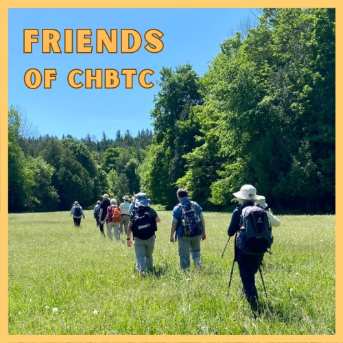
Nature Seekers - Exploring the Hockleycrest Area
https://hikesstaging.brucetrail.org/event/nature-seekers-exploring-the-hockleycrest-area-2/Sorry, the registration cut-off time for this hike has been reached.Not a member? Click here to join today!Hosting Club: Caledon Hills
Category: Introductory
Location (Google Maps): Meet at the Bruce Trail Parking Lot on Mono 5 Sideroad on the north side of the road where the Trail crosses. Google GPS Coordinates: 43.974055, -79.984988Directions: From Airport Road turn east onto 5 Sideroad and drive for 600 metres. The parking lot is on the left hand side.
Hike Leader(s): Sandy Green and Dylan “Lana” Hubbard Click here to contact Hike Leader(s)
Pace: Leisurely – 3 km/hour or less
Terrain: Moderate – some hills and/or some poor footing
Distance: 5.5 kilometresDescription
Loop through the Hockleycrest area on main and side trails. Bring your choice of hydration and snacks. Sturdy footwear is highly recommended. This hike can be counted towards your 60 for the 60th Connecting People With Nature badge.Boyd’s Crevices
https://hikesstaging.brucetrail.org/event/boyds-crevices-6/Sorry, the registration cut-off time for this hike has been reached.Not a member? Click here to join today!Hosting Club: Sydenham
Category: General Hike
Location (Google Maps): 11th Concession – north of 83.9 km where the road intersects the Owen Sound Rail Trail (Map # 32).Hike Leader(s): Ian Mills Click here to contact Hike Leader(s)
Pace: Leisurely: 3 km/h or less
Terrain: Moderate: Some hills and/or poor footing, There might be muddy sections., There might be sections with water on the trail.
Distance: 5+kmDescription
In and out hike to the giant dolostone blocks where we will have a quick break for snacks. Proper hiking footwear required and a walking stick could be helpful. BTC Map # 32.Summer Solstice Hike #5 - GeoHike
https://hikesstaging.brucetrail.org/event/summer-solstice-hike-5-geohike/Sorry, the registration cut-off time for this hike has been reached.Not a member? Click here to join today!Hosting Club: Dufferin Hi-Land
Category: General Hike
Location (Google Maps): Meet at the Whitetail Refuge parking (NW corner). Arrangements have been made to park at the new refuge for this day only due to limited parking elsewhere. Parking is on Mono Centre Road 800 m south of the intersection with Country Rd. 8. The street address is 754416 Mono Centre Rd. (which may not be accurate).
Please arrive 15 minutes early to register and sign waivers if necessary.Hike Leader(s): Lynda Bloom Click here to contact Hike Leader(s)
Pace: Leisurely
Terrain: Moderate
Distance: 8 kmDescription
Registration is required. Please complete waivers online if possible.We will walk up 2nd Line EHS into Mono Cliffs Park.
Why are there cliffs in the park? Are there any fossils? This leisurely hike will make many stops to look at rocks and talk about the geological history of the area. Don’t forget to bring your camera.
We will use several side trails, mostly the Walter Tovell and South Outlier Trails, to visit the north and south Outlier exposures.
Please wear sturdy footwear as there are hills and stairs. Pack water, snacks and dress for the weather.
Suitable for children over 10 years old.

iNaturalist Summer Solstice Hike #3
https://hikesstaging.brucetrail.org/event/inaturalist-summer-solstice-hike-3/Sorry, the registration cut-off time for this hike has been reached.Not a member? Click here to join today!Hosting Club: Dufferin Hi-Land
Category: Special Events
Location (Google Maps): Meet at Prince of Wales and 15 Sideroad Registration is not requiredHike Leader(s): Tom Thayer Click here to contact Hike Leader(s)
Pace: Leisurely
Terrain: Easy, Moderate
Distance: 6 kmsDescription
Registration is not required for this event. Please feel free to join us with or without registering.Join us for a hike through Pine River Nature Reserve and learn how to use the iNaturalist App to help the Bruce Trail protect endangered/at-risk species, monitor existing species, identify invasive species that need to be removed, and learn about the plans to enhance and enrich biodiversity.
Interact with the Bruce Trail Conservancy’s Conservation and Ecology specialists, meet some of our new trail ambassadors, and learn more about how the Dufferin Hi-Land Bruce Trail Club is working with the BTC to provide a sustainable and healthy future for generations to come.
Please Note: You will need a mobile device with the iNaturalist App installed and updated in order to take part in this event. You can download the app from the App Store or Google Play Store. More information about the iNaturalist program is available here: https://development.brucetrail.org/what-we-do/#iNaturalist
Everyone is welcome, member and non-member alike.
- 16June 16, 2024
10;00 Lock 3 picnic
https://hikesstaging.brucetrail.org/event/1000-lock-3-picnic/Sorry, the registration cut-off time for this hike has been reached.Not a member? Click here to join today!Hosting Club: Niagara
Category: In and Out
Location (Google Maps): lock 3 museumHike Leader(s): Sylvia Wheeler Click here to contact Hike Leader(s)
Pace: Medium
Terrain: Easy
Distance: 5kDescription
Hike 90 minutes. Picnic at lock 3.
Urban Walk: Lynde Shores Conservation Area
https://hikesstaging.brucetrail.org/event/urban-walk-lynde-shores-conservation-area/Sorry, the registration cut-off time for this hike has been reached.Not a member? Click here to join today!Hosting Club: Toronto
Category: Urban Walk
Location (Google Maps):Lynde Shores Conservation Area – New Parking Lot on Halls Road
Transit riders coming from Toronto can meet Tom Swales at Union Station in the Great Hall at 8.35 am. You will be taking the 8.50 GO Train to Whitby, taking a short bus ride, and will be walking down Halls Rd. to meet the drivers.
Parking Fee at the Conservation Area is $6.00 flat rate for the day
Hike Leader(s): Tom Swales, Lisa Lifshitz Click here to contact Hike Leader(s)
Pace: Moderate
Terrain: Flat
Distance: 10 kmDescription
We will hike a couple of loops, including the Chickadee Bird Feeder Trail and the Lake Ontario Trail, around the lovely Lynde Shores Conservation Area, 1225 Victoria Street, Whitby. This is a great spot for birds and other wildlife. Optional refreshment stop at the “Oak and Ale Whitby Shores” after the hike.Terrain and Speed – Flat, 3.5k, with stops for photos, viewing wildlife, or appreciating the beauty (approximately 4 hours)
Please let us know in the “Additional Information” field if you plan to take the GO Train or drive and park at the Lynde Shores Conservation Area.
- 17June 17, 2024

Sydenham Fundraiser End to End in Eight Days for the new Hart's Tongue Stained Glass Badge - June 17 - June 24/24 - Please read all details for this hike before registering.
https://hikesstaging.brucetrail.org/event/sydenham-fundraiser-end-to-end-in-eight-days-for-the-new-harts-tongue-stained-glass-badge-june-17-june-24-24-please-read-all-details-for-this-hike-before-registering/Sorry, the registration cut-off time for this hike has been reached.Not a member? Click here to join today!This is a Multi-Day Hike
You are signing up for the following dates:
2024-06-17, 2024-06-18, 2024-06-19, 2024-06-20, 2024-06-21, 2024-06-22, 2024-06-23, 2024-06-24Hosting Club: Iroquoia, Sydenham
Category: Special Event
Location (Google Maps): Bluewater Park across from the arenaHike Leader(s): Ruth Moffatt Click here to contact Hike Leader(s)
Pace: Brisk – 4 to 5 km/hr, Medium – 3 to 4 km/hr
Terrain: Dependent on Conditions, Moderate – Some hills and/or some poor footing, Strenuous – Hilly with steep climbs and some poor footing
Distance: The entire section is about 175km which will be split over 8 days. Approx. 20-25km per dayDescription
Welcome to Sydenham Bruce Trail Club – This end to end will cover the entire section over 8 days. While the section is approx 175km in length, there are about 50km on road, mostly backroads.Overview
This is a special series of 8 hikes to complete the Sydenham section of the Bruce Trail. The organization, guidance, logistics and the Hart’s Tongue stained glass badge, designed by Joe Borges is included in your fee which is non-refundable. A little bit about the Hart’s Tongue Fern: https://en.wikipedia.org/wiki/Asplenium_scolopendrium. Proceeds support the Sydenham Bruce Trail Club which in turn supports the Bruce Trail Conservancy mission to “Preserving a ribbon of wilderness, for everyone, forever.” In addition to hiking the main trail, we may hike some of the loops required for the latest book – Exploring Sydenham by Ron Savage. Hiking these loops may occur immediately after the day’s hike or during if it does not take us too far off the main trail. If this is something you wish to participate in, it is suggested you pick up a copy of this book.
For this E2E in 8, we will be following the main trail southbound from Wiarton eventually finishing in Blantyre. Please note that you are signing up for the entire series of 8 hikes as a Group Hike. The Sydenham in 8 ETE is geared to experienced long distance hikers with the expectation of a 3 to 5.0 km/ hr. pace maintained over a 20km plus day. The section is approximately 175km so daily distances will be based on available parking. No dropout points have been established and therefore hikers who must drop out, will be responsible for their own transportation back to their vehicle. Please note that transportation back to your vehicle is very limited in this section. We will hike at a steady pace but there will be plenty of time to take pictures and to enjoy the flora and fauna of this beautiful section. This particular set of 8 hikes is intended to be Moderate/Brisk. Please be honest about your degree of physical fitness and abilities prior to registration. It is a group hike so it is important you are able to keep pace with the person in front of you.
Attire and Daily Hikes.
Hikers will be expected to be wearing proper hiking boots and layered clothing with the expectation of cool or warm and possibly wet weather. Sufficient food and at least 2l of water for a full day of hiking is required as well as hiking poles (if you use them), and wet weather gear is strongly recommended. Bug spray is also suggested. Clothing adjustments, bio-breaks are as needed. Please let the sweep person know and they will wait for you. A morning break around 10am and a 10-15 minute on-trail lunch break will be scheduled. An afternoon break will be based on our expected finish time. Depending on weather conditions, these times may vary. Everyone must carry a First Aid kit.
Missing Hikes/Making-up Hikes
This is a group hike and it is intended that all participants plan to attend each day, however, if you only need a portion of this section of trail, you are welcome to join for the days or section you need. The cost is the same either way. If you intend to participate in the entire 8 days but absolutely must miss one or two days, you may self-complete these days on your own and still qualify for the stained glass badge. Since this is a car shuttle hike, please ensure your vehicle is car shuttle ready. All participants will be expected to take turns either driving to the start or driving the drivers back at the end of the day. Carpooling to our meeting spot with 2 people in the car is generally ok but we would like to minimize and equalize the driving/shuttling as much as possible so it is fair for all participants. Hikes that are completed on this series may go toward completion of an independent ETE for the regular Sydenham ETE badge if you cannot finish all 8 days.
Parking Fees
Some parking locations might require paid parking. The fee for this E2E-in-8 does not include any parking/entry fees for hikers. These costs, where applicable, will be shared amongst all participants unless you have a parking or park pass.
Leave No Trace
Please remember, like all hikes, this is a Leave No Trace hike. Pack out whatever you pack in. Do not toss anything onto or into any sections of the trail. We will also try to leave the trail better than we found it so we will be collecting any trail trash along the way if there is any.
Dogs will not be welcome on this hike.
Accommodations
It is strongly recommended you make reservations for accommodations for this hike if you are participating from out of town. Accommodations can be made anywhere but Owen Sound has many motels to choose from as well as the KOA Campground. It is pretty central to the northern and the southern sections of the Sydenham section of trail. If you would like a roommate, I can share your email with any other registered participants who are also looking for shared accommodations. Please let me know.
Daily
We meet for each hike by at least 7:45am each day. A schedule for meeting and start locations will be sent to each participant in May. We will hike southerly each day. The schedule is subject to change.
Rattlesnake Point Crawford Lake Loop
https://hikesstaging.brucetrail.org/event/rattlesnake-point-crawford-lake-loop/Sorry, the registration cut-off time for this hike has been reached.Not a member? Click here to join today!Hosting Club: Iroquoia
Category: General Hike
Location (Google Maps):Rattlesnake Point Conservation Area Parking Lot (Appleby Line 1km north of Derry Road.
Hike Leader(s): Pati Greenwood, Jeff Dowsett Click here to contact Hike Leader(s)
Pace: Medium – 3 to 4 km/hr
Terrain: Moderate – Some hills and/or some poor footing
Distance: 15KDescription
This will be a loop hike starting and ending on the Rattlesnake Point Side Trail. We will hike along the main trail as well as the Crawford Lake Side Trail, the Canyon By-Pass Side Trail and the Leach Porter Side Trail to create a loop. Regular breaks, including a lunch break will be provided. Bring a lunch, snacks and plenty of water. Wear appropriate hiking footwear as there are rocky sections along the trail. Parking reservations must be obtained from Conservation Halton. Please arrive at 8:15 am as we will leave promptly at 8:30 am. - 18June 18, 2024
NEW TIME 8:00 Long Hike Wiley Road Short Hills
https://hikesstaging.brucetrail.org/event/new-time-800-long-hike-wiley-road-short-hills-7/Sorry, the registration cut-off time for this hike has been reached.Not a member? Click here to join today!Hosting Club: Niagara
Location (Google Maps):
Short Hills Wiley Road Entrance
Pace: Medium
Terrain: Moderate
: 10kmDescription
Explore Short Hills and the majestic side trails of Scarlett Tanager, Hemlock. Swayze Falls and Terrace. Register for each hike
Bring Poles bug spray water, snack, and dress for the weather
Hogg's Falls Loops
https://hikesstaging.brucetrail.org/event/hoggs-falls-loops-3/Sorry, the registration cut-off time for this hike has been reached.Not a member? Click here to join today!Hosting Club: Dufferin Hi-Land
Category: Cancelled
Location (Google Maps):Beaver Valley Section, Map 26. Meet at SuperBurger (Intersection of Hwy 10 and 89 in Primrose) at 8:30 am or at Hogg’s Falls parking lot on Lower Valley Rd, north of Flesherton at 9:30 am.
Hike Leader(s): Les Babbage, Inge Eckerich, Julie Daley,Tony Evangelista Click here to contact Hike Leader(s)
Pace: Leisurely
Terrain: Moderate
Distance: 7.2 or 2.6 kmsDescription
We will explore a new loop created by construction of bridges across the Boyne River, joining Main Trail on the east and west banks. After returning to the parking lot, the longer hike will continue around the Uplands Meadow/Upper Beaver Valley Side Trails loop. Bring water, snacks.9:15 Short hike - Pelham Road, Short Hills
https://hikesstaging.brucetrail.org/event/915-short-hike-pelham-road-short-hills-76/Sorry, the registration cut-off time for this hike has been reached.Not a member? Click here to join today!Hosting Club: Niagara
Location (Google Maps): Short Hills Provincial Park, Pelham Road entrance
Hike Leader(s): janet davey Click here to contact Hike Leader(s)
Pace: Medium
Terrain: Moderate
Distance: 6 kmsDescription
Hike the main and side trails in Short Hills Provincial Park. Bring hiking boots, water, sunscreen and bug spray. Please check yourself for ticks after the hike.Looping through Boyne Valley Provincial Park; main trail and 4 side trails
https://hikesstaging.brucetrail.org/event/looping-through-boyne-valley-provincial-park-main-trail-and-4-side-trails/Sorry, the registration cut-off time for this hike has been reached.Not a member? Click here to join today!Hosting Club: Caledon Hills
Category: Tuesday Hikers
Location (Google Maps): Boyne Valley Provincial Park – Map 20 of the BTC Trail Guide. County Rd. 19 (Prince of Wales Rd. ) Parking Area – west of km 15.2 – approximately 80 metres south of the Prince of Wales side Trail.Hike Leader(s): Doris Harper Click here to contact Hike Leader(s)
Pace: Medium – 3 to 4 km/hour
Terrain: Moderate – some hills and/or some poor footing
Distance: 12 kmDescription
Starting from the parking lot on Prince Of Wales Rd., we will hike the Prince of Wales Side Trail, Primrose loop Side Trail, main trail, Boyne Valley Side Trail, and loop back by the main trail, and Prince of Wales Side Trail. Along the way we will also hike up the short side trail to Murphy’s Pinnacle with a 360 degree view of the surrounding landscape.Bring lunch, water, poles, the trail is hilly, dress for the weather. Tics are prevalent this year, protect yourself accordingly – sunscreen, bug spray, sun hat, long pants recommended.