
Hike Schedule
Join us for a hike! Registration required:
All hikes available to BTC members. Some hikes are open to non-members.
TIP: The calendar view displays up to 7 hikes on a day, but often there are more. Click “More events” to see them all.
Categories
- 26May 26, 2023

9:00 Floral Clock & Botanical Gardens
https://hikesstaging.brucetrail.org/event/900-floral-clock-botanical-gardens-2/Sorry, the registration cut-off time for this hike has been reached.Not a member? Click here to join today!Hosting Club: Niagara
Category: Leisurely
Location (Google Maps): Floral Clock Parking Lot (no charge)Hike Leader(s): Robin Garrett Click here to contact Hike Leader(s)
Pace: Medium
Terrain: Easy
Distance: 6 kmDescription
Enjoy the cheerfulness of budding spring flowers and trees. We will check out the new plantings at the Floral Clock, walk among the daffodils along the Niagara River Parkway trail, and loop through the Botanical Garden to revel in the magnificence of spring flowering plants and trees. - 27May 27, 2023

Blue Mountains Annual End to End-TWO DAY EVENT. This event is almost sold out, register today!
https://hikesstaging.brucetrail.org/event/blue-mountains-2-day-end2end-event/Sorry, the registration cut-off time for this hike has been reached.Not a member? Click here to join today!This is a Multi-Day Hike
You are signing up for the following dates:
2023-05-27, 2023-05-28Hosting Club: Blue Mountains
Category: End-to-End
Location (Google Maps):Hike Leader(s): Christine Lasky Click here to contact Hike Leader(s)
Pace: Brisk – 4 to 5 km/hr, Fast – 5+ km/hr
Terrain: Moderate – Some hills and/or some poor footing, Strenuous – Hilly with steep climbs and some poor footing
Distance: 69 km -Day 1: 35km Day 2: 34kmDescription
Join us this spring for the Blue Mountains Bruce Trail Club annual End-to-End hike event. This 2 Day Hike is for those hikers keen on a great big challenge You will wind your way through the beautiful and varied terrain of the Blue Mountains Club trails. Enjoy the early signs of nature awakening at this time of the year, the beautiful vistas and the rugged escarpment. You will cover the 69 km distance of our section which runs from Lavender to Swiss Meadows. Checkpoint stations will be offered approximately every 10 kms offering snacks, water refill and assistance along the way. A BBQ at Highlands Nordic is included at the end of Saturday Hike commencing at 3:00 pm. Hike details will be emailed to participants shortly after registration is received. Note, this event consists of longer distances and is generally not suitable for beginning hikers.Blue Mountains THREE DAY End to End - THREE DAY EVENT (Sorry, this Event is Now Full - with a long wait list. The Two Day hike is almost full, register for it today. Good Luck!
https://hikesstaging.brucetrail.org/event/blue-mountains-annual-end-to-end-three-day-event/Sorry, the registration cut-off time for this hike has been reached.Not a member? Click here to join today!This is a Multi-Day Hike
You are signing up for the following dates:
2023-05-27, 2023-05-28, 2023-05-29Hosting Club: Blue Mountains
Category: End-to-End
Location (Google Maps):Hike Leader(s): Christine Lasky Click here to contact Hike Leader(s)
Pace: Brisk – 4 to 5 km/hr, Medium – 3 to 4 km/hr
Terrain: Moderate – Some hills and/or some poor footing, Strenuous – Hilly with steep climbs and some poor footing
Distance: 69 kmDescription
Join us this spring for the Blue Mountains Bruce Trail Club all-new THREE DAY End-to-End hike event. This 3 Day hike is for those hikers wanting to complete our section over three days. You will wind your way through the beautiful and varied terrain of the Blue Mountains Club trails. Enjoy the early signs of nature awakening at this time of the year, the beautiful vistas and the rugged escarpment. You will cover the 69 km distance of our section which runs from Lavender to Swiss Meadows. Checkpoint stations will be offered approximately every 10 kms offering snacks, water refill and assistance along the way. A BBQ is included on the Saturday at the end of the hike day, at Highlands Nordic, and will commence at 3:00 pm. Details will be emailed to participants shortly after registration is received. Note, this event consists of longer distances and is generally not suitable for beginning hikers.Beaver Valley Section Hike 1: Swiss Meadows to Kolapore
https://hikesstaging.brucetrail.org/event/beaver-valley-section-hike-1-swiss-meadows-to-kolapore/Sorry, the registration cut-off time for this hike has been reached.Not a member? Click here to join today!Hike open to BTC Members only.
Hosting Club: Dufferin Hi-Land
Category: General Hike
Location (Google Maps): Maple Lane Black BTC parking at km 0.0 Beaver Valley Section, BTC Map 24. N 44.504973, W 80.331780. Closest major intersection is at Banks where Hwy 119 crosses 4th Line. Our meeting spot is north and east of that.Hike Leader(s): Stuart Law Click here to contact Hike Leader(s)
Pace: Medium
Terrain: Dependent on Conditions, Moderate, Slippery Sections Likely
Distance: 24.5 kmsDescription
Join us on the first of a series of hikes to complete a Beaver Valley Section E2E. This hike is very long at 24.5 kms but the rest of the hikes will be about 15 kms each to accommodate the more difficult terrain in the valley itself. While our first hike is long we will be hiking it at a Humane Hiking pace (or as a very accomplished Toronto section hike leader once said – an “all day” pace) and we will stopping regularly to rest and hydrate. Please make sure you are ready to shuttle at 8:00 am sharp. A local overnight stay is recommended given the early start. Please bring 3L of water, a lunch, snacks, bug spray, sun block, an appreciation of nature and a smile. Hiking boots mandatory. Gaiters and poles recommended. Please bring a change of footwear and a garbage bag for the shuttle given the anticipated mud in spots along the way. No dropouts. Please be honest with your ability to hike the 24.5 km distance.Cherry Beach Down town Toronto
https://hikesstaging.brucetrail.org/event/cherry-beach-down-town-toronto/Sorry, the registration cut-off time for this hike has been reached.Not a member? Click here to join today!Hosting Club: Toronto
Category: Car Hike
Location (Google Maps): free parking lot at the end of Cherry StreetHike Leader(s): Mohammad Aghamiri Click here to contact Hike Leader(s)
Pace: Moderate
Terrain: Flat
Distance: 14-15KMDescription
Park in Cherry Beach parking lotWe will explore Tommy Thompson park along Lake Ontario and listen to the birds and visit light house at the end of park.
Some safety procedures during the hike:
1-Hikers must stay between the leader and the sweep.
2-Hikers must advise the leader or the sweep if they wish to leave the group.
3- Hikers must follow the whistle instructions: 1 blast- stay where you are; 2 blasts come to the leader; 3 blasts – come to the leader quickly.
4-Hike leader may request volunteers to stop at trail intersections, they need to help hikers to the direction the group walk and wait till they see the sweep .
5-Hikers have to make sure they can see the persons behind and in front of them.
Bus Hike: Dundas Valley
https://hikesstaging.brucetrail.org/event/bus-hike-dundas-valley/Sorry, the registration cut-off time for this hike has been reached.Not a member? Click here to join today!Trip Information
Departure Time: 08:30
Return to City Time: 17:30
Departure Point: Kipling Departure PointOptional Items
Shawn & Ed Brewery Visit ($.01)Hosting Club: Toronto
Category: Bus Hike
Location (Google Maps): Dundas Valley Conservation AreaHike Leader(s): Tom Swales, Peter Leeney, Tim Wainwright Click here to contact Hike Leader(s)
Pace: Moderate
Terrain: Hilly, Variable
Distance: 12 KMDescription
Join us for a Spring hike from Ancaster through the Dundas Valley Conservation Area on the Spring Valley Trail, Hilltop Trail, Headwaters Trail, Bruce Trail, McCormack Trail into the town of Dundas Ontario – “The Valley Town”. Hopefully, we’ll have the chance to enjoy the Spring wildflowers. Before returning to Toronto there will be the chance to explore the charming town, a glass or flight at the local craft brewery, or a refreshment stop of your choice..Urban Walk: Leslie Street Spit Bird Watching
https://hikesstaging.brucetrail.org/event/urban-walk-leslie-street-spit-bird-watching-2/Sorry, the registration cut-off time for this hike has been reached.Not a member? Click here to join today!Hosting Club: Toronto
Category: Urban Walk
Location (Google Maps):Entrance to Tommy Thompson Park at Leslie St and Unwin Ave.
Hike Leader(s): Ray Berzins Click here to contact Hike Leader(s)
Pace: Leisurely
Terrain: Flat
Distance: 7 kmDescription
For first 3.5 km we will try to observe as much as possible along natural footpaths, so wear long pants, long stockings and whatever else will protect you from ticks. Bring binoculars. After lunch the nature walk will end and hikers can use the Multi-use Trail to continue walking to the end of the spit or return back to the park entrance by 2PM. It will be cooler and more windy than inland so bring warm clothing and a warm beverage with your lunch.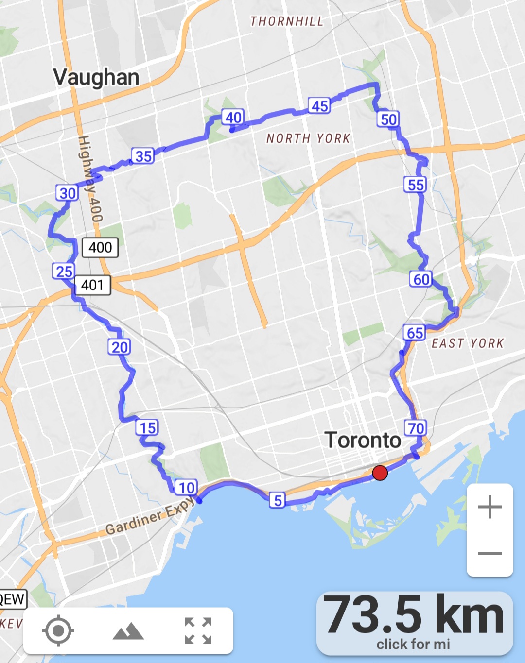
#2/5 Loop of Toronto Hike for Urban Hiking Badge - 18km
https://hikesstaging.brucetrail.org/event/2-5-loop-of-toronto-hike-for-urban-hiking-badge-18km/Sorry, the registration cut-off time for this hike has been reached.Not a member? Click here to join today!Hosting Club: Toronto
Category: Urban Walk
Location (Google Maps): Old Mill Station entranceHike Leader(s): Alina Lin
Pace: Moderate
Terrain: Flat
Distance: 18kmDescription
Embark on a captivating journey through Toronto’s remarkable urban trail systems. From the scenic Don River in the east to the captivating Waterfront in the south, the tranquil Humber River in the west, and the enchanting Finch Corridor in the north, this diverse collection of trails offers an unforgettable opportunity to explore the city’s longest trails on foot.By interconnecting these four trail systems, which weave through more than ten parks and trails, we are creating an awe-inspiring loop spanning approximately 74 kilometers: https://onthegomap.com/s/c2c1hf3n . As a testament to your accomplishment, completing the entire loop will earn you the Toronto Urban Hiking Badge—the first ever urban hiking badge launched by the Toronto Bruce Trail Club.
Distance: 18km. Start from Old Mills and end at Finch & Weston.
Pace: 4kph
Trail condition: mostly flat and paved.
Bring water and snacks. Dress and prepare for the weather.
Nature Hike - observing signs of Spring
https://hikesstaging.brucetrail.org/event/nature-hike-observing-signs-of-spring/Sorry, the registration cut-off time for this hike has been reached.Not a member? Click here to join today!Hosting Club: Niagara
Category: Hike
Location (Google Maps): Fireman’s Park, Niagara Falls. Lower parking lot, off Dorchester Rd.Hike Leader(s): Mary-Lyn Hopper Click here to contact Hike Leader(s)
Pace: Leisurely
Terrain: ModerateDescription
- In this leisurely hike we will observe signs of nature
Georgian Bluffs - top of Kemble Mountain
https://hikesstaging.brucetrail.org/event/georgian-bluffs-top-of-kemble-mountain-2/Sorry, the registration cut-off time for this hike has been reached.Not a member? Click here to join today!Hosting Club: Sydenham
Category: General Hike
Location (Google Maps): The Owen Sound Galaxy Theatre parking lot. Meet at the tall “Galaxy Centre” sign next to the traffic lights.Hike Leader(s): Ian Mills Click here to contact Hike Leader(s)
Pace: Medium: 3 to 4 km/h
Terrain: Strenuous: Hilly with steep climbs and some poor footing., There might be muddy sections., There might be sections with water on the trail.
Distance: 10 kmDescription
Starting at 145.3 (Map 34) and taking the Main Trail to the Mystery Cabin side trail and returning via the Main Trail to Nels Maher side trail. If you are unable to register please call or text Ian Mills @ 416-848-8818.Bruce Trail Family Walk
https://hikesstaging.brucetrail.org/event/bruce-trail-family-walk/Sorry, the registration cut-off time for this hike has been reached.Not a member? Click here to join today!Hosting Club: Sydenham, Peninsula
Location (Google Maps): Meet at the Bluewater Park Municipal Parking Lot in Wiarton (near Dockside Willie’s) a few minutes prior to 2:30 p.m.
Hike Leader(s): Marg Glendon
Pace: Leisurely
Terrain: Easy
Distance: ~2 KMDescription
Join a Bruce Trail Hike Leader for a short family nature scavenger hike along the Bruce Trail at Bluewater Park in Wiarton. This is an easy hike along flat terrain (fine gravel and paved surface). Learn about the Bruce Trail and how to find your way on the Bruce Trail. Help your child participate in a nature scavenger hunt along the hike. At the end of the hike, we will share our observations and talk about what we saw with one another! Bring a snack and enjoy a family picnic at the end of our hike, together!What to wear and bring:
Wear sturdy walking shoes, hat, sun protective clothing, and sunscreen. Bring water bottle for each person, a light backpack, cell phone, snacks for your family. A cell phone would be helpful, but not essential.
FREE!
- 28May 28, 2023
Toronto Section E2E 1/4
https://hikesstaging.brucetrail.org/event/toronto-section-e2e-1-4/Sorry, the registration cut-off time for this hike has been reached.Not a member? Click here to join today!Hosting Club: Niagara, Toronto
Category: Car Pool
Location (Google Maps): We meet each other on the east side of the road where the trail crosses Fourth Line. Please note that you should not park in front of the junkyard.Hike Leader(s): Mehrnoush Ahmadi Click here to contact Hike Leader(s)
Pace: Medium
Terrain: Moderate
Distance: 17kmDescription
This is the first leg of the Toronto section E2E hike, which is divided into four parts. Each part requires separate registration.If you would like to receive the badge for completing the E2E, there is a fee of ten dollars.
IF THE HIKERS WOULD LIKE TO OBTAIN THE NEW FOUND RAISING BADGE, they have the option to e-transfer the fee (The fee is $30.00 for BTC members and $40.00 for non-members) to the TBTC treasurer’s email at tbtctreasurer211@gmail.com and receive it when complete the section.
Please note that this is a carpool hike, so it’s important to come with an empty car and be prepared for carpooling and sharing rides. The parking fees will be determined and divided among the hikers
Dress appropriately for the weather conditions. Make sure to bring snacks, lunch, and a minimum of 2 liters of water.
During the hike, we will take short water breaks, as well as a 30-minute lunch break.
Every body is welcome! See you there!
Urban Walk: Whitby to Oshawa
https://hikesstaging.brucetrail.org/event/urban-walk-whitby-to-oshawa-2/Sorry, the registration cut-off time for this hike has been reached.Not a member? Click here to join today!Hosting Club: Toronto
Category: Urban Walk
Location (Google Maps):Whitby, Ontario
Hike Leader(s): Brian Rideout Click here to contact Hike Leader(s)
Pace: Moderate
Terrain: Flat
Distance: 10 kmDescription
Please join me under the clock in the Great Hall of Union Station by 9:05 am. We will take the eastbound Lakeshore train departing 9:20 AM, arriving in Whitby at 10:13 AM. If you prefer to drive, please meet at the north entrance of Whitby Go Station near the washrooms and the ticket counter.Please check out the GO Transit website and consider purchasing a one day pass for $10.
We will hike south to the lake and east to Oshawa along the Waterfront Trail for an estimated distance of 9.5 km. We will pass through several parks in Whitby and Oshawa along the way.While in Oshawa we will take Durham Region Transit to the Fox and the Goose pub and to Oshawa GO so please bring your Presto card and / or cash fare. Please bring sun screen, bug spray, a light snack and at least 2 liters of water.Here is a map of our route: https://onthegomap.com/s/0v859vb3Sunday Social Hike - Boyd’s Crevices
https://hikesstaging.brucetrail.org/event/sunday-social-hike-boyds-crevices/Sorry, the registration cut-off time for this hike has been reached.Not a member? Click here to join today!Hosting Club: Sydenham
Category: General Hike
Location (Google Maps): 11th Concession – north of Km 86.5 where the road intersects the Owen Sound Rail Trail (Map 32)Hike Leader(s): Ian Mills Click here to contact Hike Leader(s)
Pace: Leisurely: 3 km/h or less
Terrain: Moderate: Some hills and/or poor footing, There might be muddy sections., There might be sections with water on the trail.
Distance: 5 kmDescription
In and out hike to the giant dolostone blocks where we will have a quick break for snacks. Proper hiking footwear required and a walking stick will be helpful. BTC Map # 32. If you are unable to register, please call or text Ian Mills @ 416-848-8818. - 29May 29, 2023
8:30 Rockway
https://hikesstaging.brucetrail.org/event/830-rockway/Sorry, the registration cut-off time for this hike has been reached.Not a member? Click here to join today!Hosting Club: Niagara
Category: Hike
Location (Google Maps): Rockway Conservation Area, Pelham RdHike Leader(s): Sam Rutherford Click here to contact Hike Leader(s)
Pace: Medium
Terrain: Strenuous
Distance: 6kDescription
Rocky hike through woodland with hills and spectacular water fallCANCELLED Christie Lake Round the Lake Trail
https://hikesstaging.brucetrail.org/event/christie-lake-round-the-lake-trail/Sorry, the registration cut-off time for this hike has been reached.Not a member? Click here to join today!Hosting Club: Iroquoia
Category: General Hike
Location (Google Maps): Christie Lake Conservation AreaHike Leader(s): Bronwen Tregunno Click here to contact Hike Leader(s)
Pace: Leisurely – 3km/hr or less
Terrain: Moderate – Some hills and/or some poor footing
Distance: 7-8 kmDescription
CANCELLED. So sorry everyone but something popup up and I can’t lead this hike! See you next time. We’ll meet at the main parking lot once you enter the main gate to Christie CA 43.282473,-80.0277386 which is just to right at first fork. We’ll walk around the lake with a short detour to look at Darnley Mill Ruins & Cascades at Christie Dam. Bring your lunch and drink and we might picnic at one of the pavilions if the weather is nice. During the week the gate is unmanned and fee is $16 per vehicle or free with HCA annual vehicle pass. https://conservationhamilton.ca/admissions-fees/ For hiking bring snack, water, insect repellant, sun filter and personal first aid kit. Ticks are active so long pants recommended. More information at https://conservationhamilton.ca/blog/tick-safety/ Contact Bron brontreg@cogeco.ca or 905-334-4013 for more information.