
Hike Schedule
Join us for a hike! Registration required.
All hikes available to BTC members. Some hikes are open to non-members.
See Refund Policy for Paid Hikes >
TIP: The calendar view displays up to 7 hikes on a day, but often there are more. Click “View more events” to see them all.
Categories
- 08October 8, 2023
Niagara Falls: White Water Walk, Cham Shan Temple & Niagara Recreation Trail
https://hikesstaging.brucetrail.org/event/niagara-falls-white-water-walk-cham-shan-temple-niagara-recreation-trail/Sorry, the registration cut-off time for this hike has been reached.Not a member? Click here to join today!Hike open to BTC Members only.
Hosting Club: Toronto
Category: Urban Walk
Location (Google Maps): Niagara FallsHike Leader(s): Celia Ho Click here to contact Hike Leader(s)
Pace: Leisurely
Terrain: Flat
Distance: 10 kmDescription
Spend a leisure day at Niagara Falls by taking the Go Train. Visit the White Water Walk (White Water Walk – Explore the self-guided walk and white water rapids (niagaraparks.com)) and Cham Shan Temple (Ten Thousand Buddhas Sarira Stupa) (Ten Thousand Buddhas Sarira Stupa – Visiting Niagara Falls), and stroll along the Niagara Recreation Trail taking in the view of the falls at the Horseshoe Falls. Free time after to visit pubs/cafes/shops and other attractions. Return by Go train to Union Station at your leisure.
Itinerary:
8:45 AM – Meet at Union Go Train station to take the Go Train
11:30 AM – Arrive at Niagara Falls Go Train station
Lunch
12:00 PM – Visit White Water Walk (Optional) – Admissions = $17.50 per adult (Book your ticket here for the 12 PM timeslot: White Water Walk – Explore the self-guided walk and white water rapids (niagaraparks.com) )
1:00 PM – Visit Cham Shan Temple (Ten Thousand Buddhas Sarira Stupa) (Optional) – Admissions = N/A
2:00 to 4:00 PM – Walk to the Horseshoe Falls and back (Optional)
Please see the route map for your reference: https://onthegomap.com/s/52amkc7o
Wiarton to Lion's Head #4: Jackson's Cove to Barrow Bay
https://hikesstaging.brucetrail.org/event/wiarton-to-lions-head-4-jacksons-cove-to-barrow-bay/Sorry, the registration cut-off time for this hike has been reached.Not a member? Click here to join today!Hike open to BTC Members only.
Hosting Club: Dufferin Hi-Land
Category: General Hike
Location (Google Maps): Barrow Bay BTC parking lot on County Road #9 just south of McKague Road. Km 67.9 BTC Map 38.Hike Leader(s): Stuart Law Click here to contact Hike Leader(s)
Pace: Medium
Terrain: Slippery and Steep Sections, Slippery Sections Likely, Strenuous
Distance: 16.3 kms.Description
Join us rain or shine for this series of Peninsula shuttle hikes from Wiarton to Lion’s Head. The terrain is demanding but stunning. Hikes range from 15 to 19 km. See individual hike descriptions for details. Please be ready for rocks, poison ivy, bugs and ticks. Hiking boots and poles mandatory. Lots of climbing, some mud and a lot of laughs. Please arrive 15 minutes ahead of time because our departure times are firm. Please bring your own first aid kit with moleskin, 2.5L water, lunch, snack and a change of footwear and a garbage bag (for the shuttle). Please be prepared to use your vehicle for the shuttle. No dogs and no dropouts. Km references are to 31st Edition Bruce Trail Reference.Fall Colours in Toronto Parks & Ravines: Crothers Woods
https://hikesstaging.brucetrail.org/event/fall-colours-in-toronto-parks-ravines-crothers-woods/Sorry, the registration cut-off time for this hike has been reached.Not a member? Click here to join today!Hosting Club: Toronto
Category: Urban Walk
Location (Google Maps): Meet at Crothers Woods Main Entrance at the SW Corner of Loblaws Parking LotHike Leader(s): Sajedeh Zahraei Click here to contact Hike Leader(s)
Pace: Leisurely, Moderate
Terrain: Flat, Variable
Distance: 6 KMDescription
This is the second walk in a 4 part series of fall colour walks in Toronto Parks and Ravines. You may sign up for any or all walks in the series. Join us in hiking Crothers Woods trails and enjoy the beautiful fall colours. The trail is variable and narrow in some sections which are also popular with mountain bikers. Sun Valley and Cotton Wood sections are flat where we can enjoy a leisurely walk and see sections of the Lower Don River. Wear hiking boots or comfortable running shoes, bring water and snacks.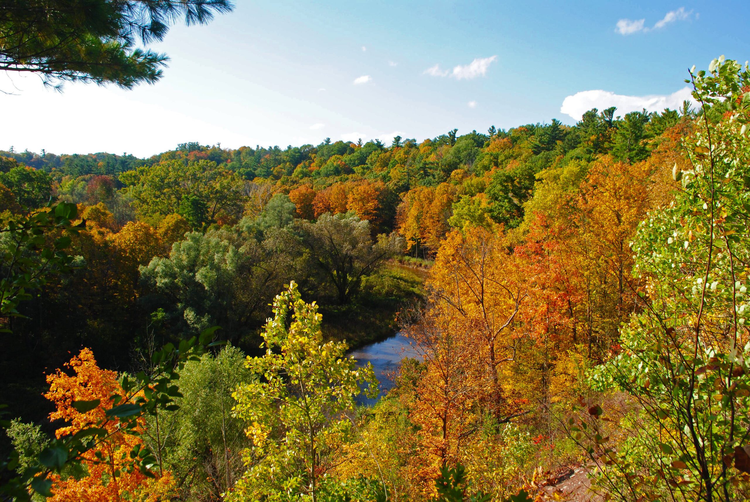
Urban Walk: 16 Mile Creek, Oakville
https://hikesstaging.brucetrail.org/event/urban-walk-16-mile-creek-oakville-3/Sorry, the registration cut-off time for this hike has been reached.Not a member? Click here to join today!Hosting Club: Toronto
Category: Urban Walk
Location (Google Maps):Starts and ends at Oakville GO Station
Hike Leader(s): Ginny Giraudi Click here to contact Hike Leader(s)
Pace: Moderate
Terrain: Other (Refer to Description)
Distance: 15 kmDescription
Not a big fan of dry turkey or your in-laws? Tell them you can’t attend, you have booked a hike for Thanksgiving Sunday and it is too late to cancel!This hike explores the Lion’s Valley ravine created by the 16-Mile Creek in Oakville. The hike starts and ends at the Oakville GO Station.
If you are planning to travel by GO train to Oakville from Union Station, you will be taking the 8:44 am westbound train. Please use the bathroom while on the GO train as there is little time for it at the Oakville GO station.
We will all meet at 9:25 am at the Oakville Transit Bus Platform 27 at the Oakville GO Station (click here for station diagram.) From here we will board Bus 13 at 9:40 am and take a short bus ride to the start point of our hike. Oakville Transit buses accept Presto, and if you have paid for the GO train, the fare for the Oakville bus will register as zero. We will walk a 15 km looping trail through the 16-Mile Creek ravine (click here for route map), stopping at the halfway point for lunch (port-a-potties only; bring hand sanitizer and tp) and return to the Oakville GO Station. The trail is stone dust gravel or asphalt and mostly flat except for two steep declines and two long climbs. There is one long set of stairs to descend. The after-hike pub stop is at the Beertown Public House (click here for menu) near the Oakville GO Station.
You can also drive to the Oakville Station and meet us there. Parking is free on the weekends. You may also choose to park in a parking lot located at the intersection of McCraney St. W. and Old Upper Middle Road approximately 1 km from where we enter the trail system. Please park by 9:30 am and walk to the trail entry to meet us there by 9:50 am.
Sunday Social Hike - Palisades figure 8 loop
https://hikesstaging.brucetrail.org/event/sunday-social-hike-palisades-figure-8-loop/Sorry, the registration cut-off time for this hike has been reached.Not a member? Click here to join today!Hosting Club: Sydenham
Category: General Hike
Location (Google Maps):Roadside parking on Owen Sound 7th Ave. E. just south of 1st St. E., west of km 90.2 (Map 32)
Hike Leader(s): Bill Snel Click here to contact Hike Leader(s)
Pace: Leisurely: 3 km/h or less
Terrain: Moderate: Some hills and/or poor footing, Strenuous: Hilly with steep climbs and some poor footing.
Distance: 1.8 kmDescription
A figure 8 hike on the east side of Owen Sound with many interesting rock formations. It also contains 1 Secret of Sydenham. For more information contact Bill Snel at w.snel2@gmail.com or call landline (519) 470-0584. If unable to register phone the hike leader. - 09October 9, 2023
Wiarton to Lion's Head #5: Barrow Bay to Lion's Head
https://hikesstaging.brucetrail.org/event/wiarton-to-lions-head-5-barrow-bay-to-lions-head/Sorry, the registration cut-off time for this hike has been reached.Not a member? Click here to join today!Hike open to BTC Members only.
Hosting Club: Dufferin Hi-Land
Category: General Hike
Location (Google Maps): Lion’s Head arena. 4 Tackabury Street, Lion’s Head. Paid parking ($20.00). Prior online reservation required. Please contact hike leader for details. About 1 km west of km 81.5, BTC Map 38.Hike Leader(s): Stuart Law Click here to contact Hike Leader(s)
Pace: Medium
Terrain: Slippery and Steep Sections, Slippery Sections Likely, Strenuous
Distance: 16.5 kms.Description
Join us rain or shine for this series of Peninsula shuttle hikes from Wiarton to Lion’s Head. The terrain is demanding but stunning. Hikes range from 15 to 19 km. See individual hike descriptions for details. Please be ready for rocks, poison ivy, bugs and ticks. Hiking boots and poles mandatory. Lots of climbing, some mud and a lot of laughs. Please arrive 15 minutes ahead of time because our departure times are firm. Please bring your own first aid kit with moleskin, 2.5L water, lunch, snack and a change of footwear and a garbage bag (for the shuttle). Please be prepared to use your vehicle for the shuttle. No dogs and no dropouts. Km references are to 31st Edition Bruce Trail Reference. Paid parking $20.00. Please contact hike leader for details.Urban Walk: Highland Creek Loop
https://hikesstaging.brucetrail.org/event/urban-walk-highland-creek-loop/Sorry, the registration cut-off time for this hike has been reached.Not a member? Click here to join today!Hosting Club: Toronto
Category: Urban Walk
Location (Google Maps): Morningside ParkHike Leader(s): Lindita Kalo Click here to contact Hike Leader(s)
Pace: Moderate
Terrain: Flat
Distance: 16KmDescription
Thanksgiving hike. Meet 9:45am for TTC rides at south/west corner of Ellesmere Rd & Morningside Av. 10:00am for drivers at 390 Morningside Av Parking. This lovely paved section include Highland Creek trail through forest, Waterfront trail along lake Ontario, some road walking to connect the loop. Please bring water and lunch. Optional drop at Guildwood station intersection of Kingston Rd & Celeste Dr. - 10October 10, 2023
8:00 Long Hike Wiley Road Short Hills
https://hikesstaging.brucetrail.org/event/800-long-hike-wiley-road-short-hills-35/Sorry, the registration cut-off time for this hike has been reached.Not a member? Click here to join today!Hosting Club: Niagara
Location (Google Maps):
Short Hills Wiley Road Entrance
Pace: Medium
Terrain: Moderate
: 10kmDescription
Explore Short Hills and the majestic side trails of Scarlett Tanager, Hemlock. Swayze Falls and Terrace. Register for each hike
Bring Poles water, snack, sunscreen and bug spray and dress for the weather
Fairmount - Siegerman Loop
https://hikesstaging.brucetrail.org/event/fairmount-siegerman-loop-2/Sorry, the registration cut-off time for this hike has been reached.Not a member? Click here to join today!Hosting Club: Sydenham
Category: General Hike
Location (Google Maps): Roadside parking on Sideroad 22B just east of Grey Road 7 at Km 98.3 (Map 27). We will meet at the Blue sign for the Fairmount side trail.Hike Leader(s): Fran Turner Click here to contact Hike Leader(s)
Pace: Brisk: 4 to 5 km/h
Terrain: Strenuous: Hilly with steep climbs and some poor footing.
Distance: 11.5 kmDescription
This is a popular hike due to the spectacular vistas of the Beaver Valley. However, it includes several long and steep uphills and downhills, so is not for inexperienced hikers. We begin at the top of the Escarpment and descend into the Beaver Valley, then travel beside a pretty stream along the Siegerman side trail. We climb back out of the valley and make our way to the very scenic Webwood Falls where we will enjoy a break and snack. Then we hike back to the cars via the Fairmount side trail which offers gorgeous views of the Beaver Valley.9:15 Short Hike - Pelham Road, Short Hills
https://hikesstaging.brucetrail.org/event/915-short-hike-pelham-road-short-hills-63/Sorry, the registration cut-off time for this hike has been reached.Not a member? Click here to join today!Hosting Club: Niagara
Location (Google Maps): Pelham Road entrance, Short Hills Provincial Park
Hike Leader(s): janet davey Click here to contact Hike Leader(s)
Pace: Medium
Terrain: Moderate
Distance: 6 kmsDescription
Hike the main and side trails of Short Hills Provincial Park. Bring water.Hogg's Falls Loops
https://hikesstaging.brucetrail.org/event/hoggs-falls-loops-2/Sorry, the registration cut-off time for this hike has been reached.Not a member? Click here to join today!Hosting Club: Dufferin Hi-Land
Category: Tuesday Hike
Location (Google Maps): Beaver Valley Section, Map 26. Meet at SuperBurger (Intersection of Hwy 10 and 89 in Primrose) at 9:30 am or at Hogg’s Falls parking lot on Lower Valley Rd, north of Flesherton at 10:00 am.Hike Leader(s): Les Babbage, Inge Eckerich, Julie Daley Click here to contact Hike Leader(s)
Pace: Leisurely
Terrain: Moderate, Slippery and Steep Sections
Distance: 7.2 or 2.6 kmsDescription
We will explore a new loop created by construction of a bridge across the Boyne River, joining Main Trail on the east and west banks. After returning to the parking lot, the longer hike will continue around the Uplands Meadow/Upper Beaver Valley Side Trails loop. Bring water, snacks.Blue Mountains - Devil's Glen
https://hikesstaging.brucetrail.org/event/blue-mountains-devils-glen-2/Sorry, the registration cut-off time for this hike has been reached.Not a member? Click here to join today!Hosting Club: Caledon Hills
Category: Car Hike
Location (Google Maps):Parking lot at km 31.7 Map 22.Take Hwy 10 North. At Primrose turn left then in 5 km turn right on County Rd. 124. Follow for 30 km. In village of Singhampton turn right and follow #124 for 4 km to Devil’s Glen parking on the right. Leader’s cell phone 905-301-4091.
Hike Leader(s): Peter Leeney Click here to contact Hike Leader(s)
Pace: Moderate
Terrain: Hilly
Distance: 9 km loopDescription
This is a loop hike going south from the Devil’s Glen parking lot on the Main Trail to the Mad River Side Trail. We will return on the Mad River Side Trail to the Devil’s Glen parking. Note: Because of a re-route, this hike is about 2 km shorter than in previous years and a bit less hilly. - 11October 11, 2023
Frontenac Challenge 2023 - Special 7-Day Hiking Event in Frontenac Provincial Park located north of Kingston
https://hikesstaging.brucetrail.org/event/frontenac-challenge-2023-special-7-day-hiking-event-in-frontenac-provincial-park-located-north-of-kingston/Sorry, the registration cut-off time for this hike has been reached.Not a member? Click here to join today!Hike open to BTC Members only.
This is a Multi-Day Hike
You are signing up for the following dates:
2023-10-11, 2023-10-12, 2023-10-13, 2023-10-14, 2023-10-15, 2023-10-16, 2023-10-17Hosting Club: Iroquoia
Category: Special Event
Location (Google Maps): Frontenac Provincial Park is about 3.5 -4 hours from Toronto and about 1 hour north of KingstonHike Leader(s): Ruth Moffatt Click here to contact Hike Leader(s)
Pace: Brisk – 4 to 5 km/hr
Terrain: Moderate – Some hills and/or some poor footing, Slippery and Steep Sections
Distance: 4.5km – 27kmDescription
This is a special, 7 day, 6 night trip to Frontenac Provincial Park. This special hiking event is a series of loop hikes called the Frontenac Challenge held in Frontenac Provincial Park. Frontenac Provincial Park is about 3.5 hours from Toronto. The 11 loops are from 1.5km to about 27km including the trail to access the trail head. Each loop has a special password which you keep track of to submit for a badge. The cost for registering for the Challenge in 2022 was $5. This includes a badge (1st, 5th, 10th etc) and certificate. A certificate for all other completions. A self-addressed 9×12”stamped envelope must be left at the park office if you want a badge/certificate.Accommodation is at Snug Harbour Resort, a short distance from the park. Four shareable cabins (#2,10,11 & 12) have been blocked off for the Bruce Trail hikers. Please contact Rob at relax@snugharbour.on.ca. Choose one of the cabins or another one of your choosing if another is available. http://snugharbour.on.ca/accommodations.htm Once you register, please let me know if you want your name shared with others to share your cabin. The rate per cabin should be $110 plus tax no matter if there are two or four sharing. This rate also includes access to boats (at your own risk), fire pits and GBBQs as needed.
Check in is October 11,2023 and check out is October 17,2023 or you may stay longer if you wish. Let Rob know you are with the Bruce Trail Group. He has agreed to give us a favourable rate ($110) as well as access to resort amenities without charge. You may also choose to stay elsewhere. Parking fees at the Frontenac Provincial Park also apply. Since we hike the first day, you may wish to check-in first and carpool from Snug Harbour over to the park for our 2:30pm start on our first day. See below. You can obtain your parking passes from the park office. Everyone will need a pass for the last day of hiking as most people drive straight home after our last hike. Borrowing a park pass from your local library, if available, or purchasing an annual pass, is encouraged. https://www.ontarioparks.com/fees/dayuse/2023
Purchase of the Frontenac Provincial Park map is strongly recommended. www.frontenacpark.caPlease note, this hike is for those who wish to complete the Frontenac Challenge, not the Frontenac Trek. There may be other hikes on the schedule for the Frontenac Trek, however,
On our first day we will meet at the provincial park to complete two short loops on the afternoon of arrival at 2:30pm. You may choose to meet at Snug Harbour and check-in before hand and car shuttle from there. Please confirm that you would like to do this with Rob at Snug Harbour.
Frontenac Challenge is a very popular hiking event – there is often wild life and the trees are in full colour. Evenings are often spent around the campfire where we will have a hotdog roast and a pot luck, or two. This will be the my 5th and last Frontenac Challenge but I’m hopeful another hike leader will continue to lead them in 2024.
If you have any questions, please email ruthdmoffatt@gmail.com
John Haigh Side Trail Loop
https://hikesstaging.brucetrail.org/event/john-haigh-side-trail-loop/Sorry, the registration cut-off time for this hike has been reached.Not a member? Click here to join today!Hosting Club: Blue Mountains
Category: Register in person the morning of hike.
Location (Google Maps): Hike meets in the parking lot behind Tim Hortons on First St. in Collingwood.Hike Leader(s): Flo Kusiak Click here to contact Hike Leader(s)
Pace: Leisurely – 3 km/hr. or less
Terrain: Easy – Mostly flat and usually good footing
Distance: 6kmDescription
We will drive to the junction of the 2nd Line and the 6th Sideroad and commence a loop hike through the upper level of the Pretty River Valley Provincial Park. Following the John Haigh Side Trail, we will head south to join the white blazed trail, then head north to km 52.6. From here we proceed west to the cars. Bring water and a snack.Hockley Valley Loop - RESCHEDULED
https://hikesstaging.brucetrail.org/event/hockley-valley-loop/Sorry, the registration cut-off time for this hike has been reached.Not a member? Click here to join today!Hosting Club: Iroquoia
Category: General Hike
Location (Google Maps): Parking in BT Parking lot on Hockley Valley RoadHike Leader(s): Pati Greenwood, Jeff Dowsett Click here to contact Hike Leader(s)
Pace: Medium – 3 to 4 km/hr
Terrain: Strenuous – Hilly with steep climbs and some poor footing
Distance: 16 kmDescription
We will hike a loop including the main trail and BT side trails in the Hockley Valley. Bring lunch and plenty of water. Wear sturdy footwear and clothing appropriate to conditions. Please arrive by 8:45 am as we will leave promptly at 9:00 AM.
9:00 Remembering the Six Nations' Role in the Battle of Queenston Heights, 13 OCT 1812
https://hikesstaging.brucetrail.org/event/900-remembering-the-six-nations-role-in-the-battle-of-queenston-heights-13-oct-1812/Sorry, the registration cut-off time for this hike has been reached.Not a member? Click here to join today!Hosting Club: Niagara
Category: Loop
Location (Google Maps):Queenston Heights Park, near Bruce Trail Southern Terminus Cairn, km 0.0. Enter from Niagara Pkwy. A parking fee is charged.
Hike Leader(s): Karen Couch Click here to contact Hike Leader(s)
Pace: Medium
Terrain: Moderate
Distance: 10 kmsDescription
This hike will recognize the contribution of the Six Nations during the Battle of Queenston Heights, Oct 13, 1812. We will take the main trail down the escarpment, the Upper Canada Heritage Side Trail, the Major Teyoninhokarawen (“Tey-oh-nin-hock-ah-RAW-wen”) John Norton Side Trail up the escarpment, and then the main trail. A final stop at the Landscape of Nations Memorial will be included. It should take 2.5-2.75 hours depending on the conditions. The climbs up and down the escarpment can be slippery and offer poor footing, particularly if there has been rain. Hiking poles are recommended.Right click on/Open the link below to view a short video on the subject.
https://www.historicacanada.ca/productions/minutes/queenston-heights
Note: Hikes are offered by volunteers who have committed to their own learning, to be able to offer informative and contemplative hike experiences. These hikes are open to all and offered in a spirit of mutual learning and inclusion.

WEDNESDAY WALKERS - Stew Hilt's Side Trail
https://hikesstaging.brucetrail.org/event/stew-hilts-side-trail-2/Sorry, the registration cut-off time for this hike has been reached.Not a member? Click here to join today!Hosting Club: Beaver Valley
Location (Google Maps): Meet in the parking lot at the end of Johnston’s Side Road off of Grey Road 32, km 74.3, Map 26
Hike Leader(s): Margaret Yaraskavitch Click here to contact the hike leader.
Pace: Medium
Terrain: Moderate, Some rocky footing, Some steep sections
Length of Hike: 5.9 kmDescription
This hike takes us through BTC protected land. We will walk through a mature deciduous forest on the Main Trail and then we’ll walk the Stew Hilt’s Side Trail. Crossing a stream, we reach a waterfall, usually trickling in the fall. Our route will have us return on the higher Main Trail which provides a beautiful view of the Cuckoo Valley, showcasing fall colour.
What's a Meromictic Lake?
https://hikesstaging.brucetrail.org/event/whats-a-meromictic-lake/Sorry, the registration cut-off time for this hike has been reached.Not a member? Click here to join today!Hosting Club: Iroquoia
Category: Good Companions
Location (Google Maps): Crawford Lake Conservation Area, Guelph LineHike Leader(s): Anne Armstrong Click here to contact Hike Leader(s)
Pace: Leisurely – 3km/hr or less
Terrain: Moderate – Some hills and/or some poor footing
Distance: Approx 6-7 km.Description
Come join me for this hike to discover what the fuss about Crawford Lake is all about (if you don’t know already). It has been in the news a lot lately. Please meet in the LOWER parking lot of Crawford Lake Conservation Area on Guelph Line at 9:45 am. for a 10:00 am. start. Bring a snack, sunscreen and hiking poles if using. You will need to make a reservation to enter. (Check out the Halton Conservation Authority website.)
Leader: Anne Armstrong 905 617 3937 hikingrandma@gmail.com