
Hike Schedule
Join us for a hike! Registration required.
All hikes available to BTC members. Some hikes are open to non-members.
See Refund Policy for Paid Hikes >
TIP: The calendar view displays up to 7 hikes on a day, but often there are more. Click “View more events” to see them all.
Categories
- 05April 5, 2025

End-to-End Makeup Hike in 8: Jones Bluff ST parking area to Hope Bay
https://hikesstaging.brucetrail.org/event/end-to-end-makeup-hike-in-8-jones-bluff-st-parking-area-to-hope-bay/Sorry, the registration cut-off time for this hike has been reached.Not a member? Click here to join today!Hike open to BTC Members only.
Hosting Club: Peninsula
Category: Peninsula E2E
Location (Google Maps): Hope BayHike Leader(s): Kathleen Stahlbaum Click here to contact Hike Leader(s)
Pace: Medium (3.0 – 4.5 km/h): A comfortable pace for most hikers with steady progress.
Terrain: Difficult: Steep ascents/descents, rocky scrambling, and some rugged escarpment paths., Moderate: Rolling hills, mild slopes and rocky paths.
Distance: 19.2Description
Expectations: Expect to be on-trail for 7-9 hours each day, depending on the daily distance. Time on the trail may vary based on terrain, conditions, and the pace of the group. Breaks will be taken for lunch, snacks, photography, and to appreciate the scenery.Meeting Time: Please arrive no later than 15 minutes prior to the scheduled time.
Participant Requirements:
- Intermediate/experienced hikers, comfortable with longer distances and elevation gains.
- Must be physically fit for group hiking.
- Proper hiking boots, layered clothing, and wet weather gear required. Hiking poles recommended.
- Essentials: Lunch, snacks, water, bug spray.
- Breaks for photography and appreciation of local flora and fauna.
Car Shuttle: Ensure your vehicle is passenger-ready.
Accommodations: Early reservations recommended, especially near meeting points or in Lion’s Head. Suggested options: motels, campgrounds, hostels, and B&Bs.
School Bus Hike: Niagara E2E #1 of 6
https://hikesstaging.brucetrail.org/event/niagara-section-e2e-1-of-6/Sorry, the registration cut-off time for this hike has been reached.Not a member? Click here to join today!Trip Information
Departure Time: 08:30
Return to City Time: 18:00
Departure Point: Kipling Departure PointOptional Items
Hosting Club: Toronto
Category: Bus Hike
Location (Google Maps): Niagara Section Kms 0.0 to 13.3Hike Leader(s): Tim Wainwright, Felix Wan Click here to contact Hike Leader(s)
Pace: Moderate (3-4 km/hr)
Terrain: Level 2 (Intermediate – some hills and uneven surfaces, rocks and roots underfoot), Variable
Distance: 13.3 kmDescription
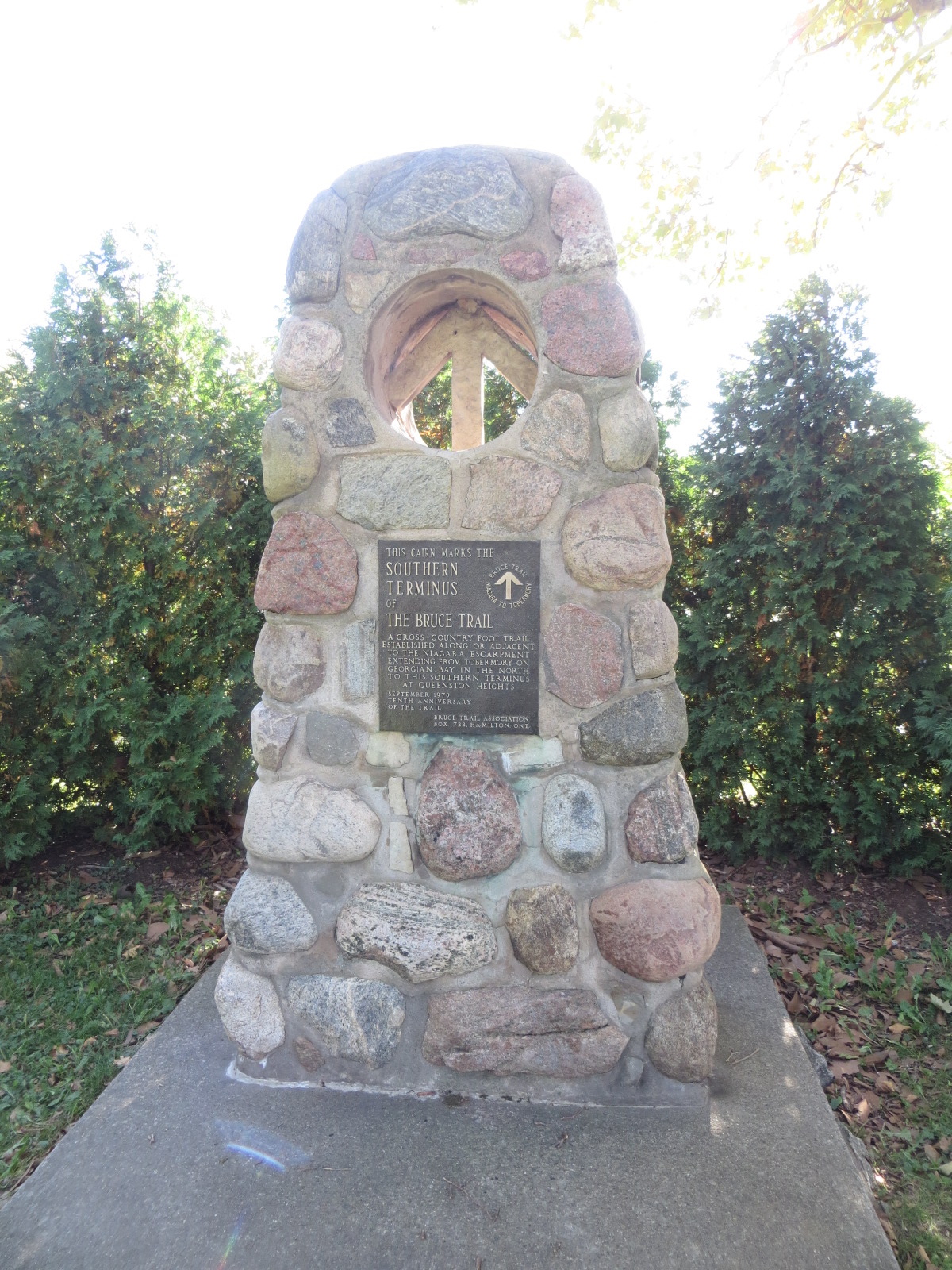
Join us for the kick-off hike of a 6 part end-to-end of the Niagara section. Our route starts at the cairn marking the southern terminus of the Bruce Trail (km 0.0, only 900 kms more to Tobermory!), in Queenston Heights Park. After passing through the park, we’ll walk along the brow of the escarpment and then follow the trail to our drop-out point at Firemen’s Park at km 7.0. Further along the way we’ll encounter the “Screaming Tunnel” underpass on our way to our ending point in the Woodend Conservation Area at km 13.3.Bring icers, a packed lunch, 2 litres of water, and sun/rain/bug protection as needed.
This hike is covered on Maps #1-2 of the Bruce Trail Reference Guide.
We will have a refreshment stop before heading back to Toronto.
The other dates for the Niagara End to End will be
2. April 19
3. May 10
4. May 17
5. May 24
6. June 7Car Hike: East Point Park Bird Sanctuary, Scarborough, ON 181
https://hikesstaging.brucetrail.org/event/car-hike-east-point-park-bird-sanctuary-scarborough-on-2/Sorry, the registration cut-off time for this hike has been reached.Not a member? Click here to join today!Hosting Club: Toronto
Location (Google Maps): East Point Park Bird Sanctuary, Scarborough, ON
parking lot at the end of Beech grove Dr.Hike Leader(s): Mohammad Aghamiri Click here to contact Hike Leader(s)
Pace: Moderate (3-4 km/hr)
Terrain: Flat
Distance: 12-14 kmDescription
We will hike along lake Ontario to Scarborough Bluffs.Please bring hiking poles, proper closing and shoes and lots of smile,
Saturday Shorts: Hockley Valley South Citizen Scientist Nature Walk
https://hikesstaging.brucetrail.org/event/saturday-shorts-hockley-valley-south-citizen-scientist-nature-walk/Sorry, the registration cut-off time for this hike has been reached.Not a member? Click here to join today!Hosting Club: Caledon Hills
Category: Nature Walks
Location (Google Maps): Meet at the BTC parking lot on the east side of the 5th Line EHS, just south of Hockley Road, 43.993572, -80.014057.Driving Directions:
From ON-10, turn east onto Hockley Road/Dufferin County Road 7. Drive for 9.5 kilometres. Turn south/right onto 5 Line E/5th Line EHS. The parking lot is on the left in 100 metres.Hike Leader(s): Sandy Green Click here to contact Hike Leader(s)
Pace: Leisurely – 3 km/hour or less
Terrain: Strenuous – hilly with steep climbs and some poor footing
Distance: 5.5 kmDescription
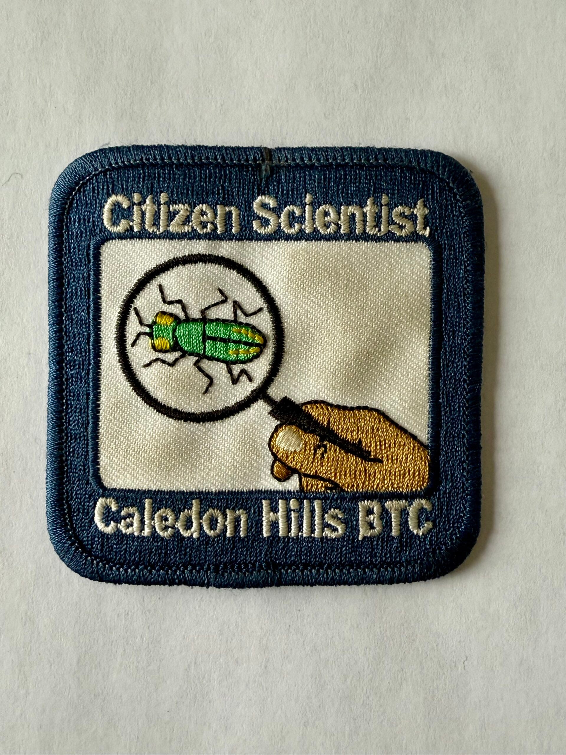
Pique your curiosity about the awakening forest in the Hockley Valley south area. Learn to use nature identification apps Merlin, Seek and iNaturalist to collect biodiversity data along the Bruce Trail for the BTC’s iNaturalist Project. Badge seekers can work towards earning the CHBTC Citizen Scientist badge.Car Hike: Hockley Valley Provincial Nature Reserve
https://hikesstaging.brucetrail.org/event/car-hike-hockley-valley-provincial-nature-reserve/Sorry, the registration cut-off time for this hike has been reached.Not a member? Click here to join today!Hosting Club: Caledon Hills
Category: General
Location (Google Maps): Hockley Valley Provincial Nature Reserve, Map 18. To reach the meeting point, drive north on Hwy 10 from Orangeville and turn right onto Hockley Road. Continue approximately 5 km east until you see the parking area on your left, directly across the road from the Black Birch restaurant.Hike Leader(s): Dylan “Lana” Hubbard Click here to contact Hike Leader(s)
Pace: Medium – 3 to 4 km/hour
Terrain: Strenuous – hilly with steep climbs and some poor footing
Distance: 15 kmDescription
Join us for a 14 km hike through the Nature Reserve, known for being one of the most challenging and hilly sections of the Bruce Trail. Get ready for a workout.We will be hiking at a moderate pace and please bring icers.
We are committed to providing an inclusive and welcoming environment. This hike is an 2SLGBTQIA+ safe space, and everyone is welcome to join us!
Cancelled due to ice storm - Dufferin Hi-Land 60th Anniversary Side Trail Highlights
https://hikesstaging.brucetrail.org/event/dufferin-hi-land-60th-anniversary-side-trail-highlights-7/Sorry, the registration cut-off time for this hike has been reached.Not a member? Click here to join today!Hosting Club: Dufferin Hi-Land
Category: Cancelled
Location (Google Maps): Park at Split Rock Narrows parking lot on 2nd Line EHS, 1.5 km north of 25 Sideroad (north of Mono Cliffs Provincial Park).Hike Leader(s): su Bate Click here to contact Hike Leader(s)
Pace: Brisk
Distance: 10km
Description
RESCHEDULED FROM LAST WEEK. This is the 3rd in a series of 6 loop hikes; each hike is between 9-12km in length. If you hike all 6 of the hikes in this series, or otherwise hike 60 km in Dufferin during 2025, you qualify for the 60th Anniversary badge.Bring a drink, a snack and ICERS. There are some steep drop offs and the trail can be slippery, icy and muddy at this time of year. Dress for the weather!We will follow Splitrock Side Trail east and south to second intersection with Ralph Tremills Side Trail. Then we follow Ralph Tremills east and return via Splitrock Side Trail west to 2ndLine. We’ll follow 2nd Line EHS Side Trail south to 25 Sideroad, cross the stile and continue south on Walter Tovell Side Trail to Clifftop Trail. Keep right on Clifftop Trail to Bruce Main Trail, following the Main Trail west and north to Lookout Side Trail (km 4.0). Take Lookout Trail north and east to Walter Tovell and return north on Walter Tovell and 2nd Line EHS Side Trail to parking lot.
- 06April 6, 2025

End-to-End Makeup Hike in 8: Hope Bay to Hawthorn ST Parking
https://hikesstaging.brucetrail.org/event/end-to-end-makeup-hike-in-8-hope-bay-to-hawthorn-st-parking/Sorry, the registration cut-off time for this hike has been reached.Not a member? Click here to join today!Hike open to BTC Members only.
Hosting Club: Peninsula
Category: Peninsula E2E
Location (Google Maps): Hawthorn ST ParkingHike Leader(s): Kathleen Stahlbaum Click here to contact Hike Leader(s)
Pace: Medium (3.0 – 4.5 km/h): A comfortable pace for most hikers with steady progress.
Terrain: Difficult: Steep ascents/descents, rocky scrambling, and some rugged escarpment paths., Moderate: Rolling hills, mild slopes and rocky paths.
Distance: 22.8Description
Expectations: Expect to be on-trail for 7-9 hours each day, depending on the daily distance. Time on the trail may vary based on terrain, conditions, and the pace of the group. Breaks will be taken for lunch, snacks, photography, and to appreciate the scenery.Meeting Time: Please arrive no later than 15 minutes prior to the scheduled time.
Participant Requirements:
- Intermediate/experienced hikers, comfortable with longer distances and elevation gains.
- Must be physically fit for group hiking.
- Proper hiking boots, layered clothing, and wet weather gear required. Hiking poles recommended.
- Essentials: Lunch, snacks, water, bug spray.
- Breaks for photography and appreciation of local flora and fauna.
Car Shuttle: Ensure your vehicle is passenger-ready.
Accommodations: Early reservations recommended, especially near meeting points or in Lion’s Head. Suggested options: motels, campgrounds, hostels, and B&Bs.

Caledon Hills E2E Stained Glass Badge Hike in 4 Hikes
https://hikesstaging.brucetrail.org/event/caledon-hills-e2e-stained-glass-badge-hike-in-4-hikes/Sorry, the registration cut-off time for this hike has been reached.Not a member? Click here to join today!This is a Multi-Day Hike
You are signing up for the following dates:
2025-04-06, 2025-04-13, 2025-04-20, 2025-04-26Hosting Club: Caledon Hills
Category: End-to-End
Location (Google Maps): Meet at km 15.9, roadside parking along the southwest shoulder of Willoughby Road near Escarpment Sideroad intersection, 43.831244, -79.980588. (Map 15, Edition 31)
Directions: From Hwy #10 head west on Escarpment Sideroad for approximately 1.5 km.Hike Leader(s): Lily Li Click here to contact Hike Leader(s)
Pace: Brisk – 4 to 5 km/hour
Terrain: Moderate – some hills and/or some poor footing
Distance: 17.3 kmDescription
Earn the Cheltenham Badlands Stained Glass/Fundraiser badge, which is part of the collectable Bruce Trail Clubs stained glass-themed fundraiser set. Hike distances range from 17 km to 20 km for the 4-day end-to-end series.Please dress according to the weather presented that day. Bring snacks and water (electrolytes) for a long day of hike.
This is a car shuttle hike. Please have your vehicle ready as everyone will be taking a turn to drive us all to the start point of our hike or to get our drivers back at the end of the day.

Bent Rim 2
https://hikesstaging.brucetrail.org/event/bent-rim-2/Sorry, the registration cut-off time for this hike has been reached.Not a member? Click here to join today!Hosting Club: Iroquoia
Category: General Hike
Location (Google Maps): Meet in the small parking lot on 6th Line.Hike Leader(s): Karen Bergmann Click here to contact Hike Leader(s)
Pace: Medium – 3 to 4 km/hr
Terrain: Moderate – Some hills and/or some poor footing
Distance: 9 kmsDescription
We will hike the Bent Rim 2 bike trail and back through the Halton Forest. Meet at 9:15 (earlier if possible) in the small parking lot on 6th Line, about 3 kms north of Campbellville Rd. Bring icers for your boots.Car Hike: Caledon Rail Trail
https://hikesstaging.brucetrail.org/event/car-hike-caledon-rail-trail-2/Sorry, the registration cut-off time for this hike has been reached.Not a member? Click here to join today!Hosting Club: Toronto
Category: Car Hike
Location (Google Maps): Caledon Rail TrailHike Leader(s): Al Brown Click here to contact Hike Leader(s)
Pace: Moderate (3-4 km/hr)
Terrain: Flat
Distance: 11 kmDescription
Come out to start the hiking season with an easy hike on the Caledon Rail Trail. This once was the main Bruce Trail. We will start in Inglewood and hike east to the village of Caledon East.To get to the meeting point drive north on Hwy 10 from Brampton to Olde Base Line Road. Turn left and go about 1.5 km to McLaughlin Road. Turn right and go north about half a km to where the Rail Trail crosses the road. Parking will be on the right. If this parking is full you may park in the recreation centre parking lot about 150 meters south, on the east side of McLaughlin.
After the hike those interested may join me for refreshments in the local area.
Urban Walk: Sherwood Park/Sunnybrook Park
https://hikesstaging.brucetrail.org/event/urban-walk-sherwood-park-sunnybrook-park-3/Sorry, the registration cut-off time for this hike has been reached.Not a member? Click here to join today!Hosting Club: Toronto
Category: Urban Walk
Location (Google Maps):NE Corner Yonge & Lawrence (by subway exit)
Hike Leader(s): Tom Swales
Pace: Moderate (3-4 km/hr)
Terrain: Variable
Distance: 12 KMDescription
Join us for a hike through ravines from Yonge & Lawrence to Sunnybrook & Serena Gundy parks to end at Brentcliffe & Eglinton. Those who wish may continue to a refreshment stop at the Longo’s on Laird Ave. - 07April 7, 2025
Blue Loop Hikes #5 - Mono Cliffs - location change to Hilton Falls due to Dufferin trail closure
https://hikesstaging.brucetrail.org/event/blue-loop-hikes-5-mono-cliffs/Sorry, the registration cut-off time for this hike has been reached.Not a member? Click here to join today!Hosting Club: Iroquoia, Caledon Hills
Category: General Hike
Location (Google Maps): Hilton Falls Conservation areaHike Leader(s): Pati Greenwood, Jeff Dowsett Click here to contact Hike Leader(s)
Pace: Medium – 3 to 4 km/hr
Terrain: Moderate – Some hills and/or some poor footing
Distance: 11 kmDescription
NOTE; WE HAVE RELOCATED THIS HIKE TO HILTON FALLS CONSERVATION AREA DUE TO DUFFERIN TRAIL CLOSURE. IT WILL BE A SIMILAR LENGTH. A PARKING FEE WILL BE REQUIRED AT HILTON FALLS.This is a series of loop hikes exploring various BT Blue trails in wintry and early spring conditions. Join us for one, some or all.
Today’s hike will explore the main trail and the various side trails for an 11 km look in Mono Cliffs Provincial Park.
Bring a snack and plenty of water, and other hydration as needed. Wear hiking boots and bring hiking poles. Icers may also be required.
Please arrive at the meeting place by 8:15 am as we will leave promptly at 8:30 am.
Peninsula Side Trail Bonanza Part 1
https://hikesstaging.brucetrail.org/event/peninsula-side-trail-bonanza-part-1/Sorry, the registration cut-off time for this hike has been reached.Not a member? Click here to join today!This is a Multi-Day Hike
You are signing up for the following dates and times:
2025-04-07 at 09:00
2025-04-08 at 09:00
2025-04-09 at 09:00Hosting Club: Sydenham, Peninsula
Category: General Hike
Location (Google Maps): Roadside parking off Mallory Beach Rd (loop 1), then drive 3 km down the road (loop 2). For first day only. All other days will have other meet locations according to itinerary.Hike Leader(s): Karen Buschert Click here to contact Hike Leader(s)
Pace: Medium: 3 to 4 km/h
Terrain: Moderate: Some hills and/or poor footing, Strenuous: Hilly with steep climbs and some poor footing.
Distance: Distances vary each day and with each loop. Up to 14-22 km in a dayDescription
Explore the side trails of the Bruce Trail! This is Part 1 of a 3 part series of multi-day hikes that will cover almost all the side trails of the Peninsula section, and yes, there is a badge for that! Most hikes will be loops of 5-15 km and you can complete a full day or join in for select loops each day depending on your preference. We will do some nature ID as well for those that are working towards birding, fern or tree badges.Part 1: April 7-9
Part 2: April 14-16
Part 3: April 28-30
Suggested accommodations: Silver Lake Mennonite Camp near Sauble Beach
slmc.ca/retreats/retreats/
Scroll to Weekday Wanders- Bruce Trail Side Trails
Stay in a retreat centre and be treated to home cooked meals while taking in the beauty of the local landscape. Shared or private rooms available.
Cost: $250+ HST, cost includes accommodation for 2 nights and 6 meals

Sweetwater Series - Hike 5 - Hockleycrest
https://hikesstaging.brucetrail.org/event/sweetwater-series-hike-5-hockleycrest/Sorry, the registration cut-off time for this hike has been reached.Not a member? Click here to join today!Hosting Club: Caledon Hills
Category: General
Location (Google Maps): Parking Lot on Mono 5 Sideroad, north side of the Road.From Airport Road, north of 9 turn east on Mono 5 Sideroad.
Hike Leader(s): Jennie Greenfield; Elizabeth Ganong Click here to contact Hike Leader(s)
Pace: Medium – 3 to 4 km/hour
Terrain: Moderate – some hills and/or some poor footing
Distance: 6.6 kmDescription
This series of five hikes celebrates the glorious sugar maple as we move from winter towards spring. The trails are all in or near the Caledon Hills section of the Bruce Trail and range from 7 to 10 km in length.Register individually for one, a few, or all of the Sweetwater Badge Hikes taking place on Mondays. Participants who complete the five hikes will be eligible to receive a Sweetwater badge. (Note: If you wish to purchase a badge, the cost is $10.00 for BTC members and $15.00 for non-members.)
Hike 5 explores the beautiful Hockleycrest property on the Main and Side Trails. The trail passes sap collection lines and a sugar shack. This hike has some hills and can be difficult under winter conditions.
Bring your choice of hydration and snacks. Hiking boots and icers/crampons are required.
Participants will be notified the night before if a hike must be cancelled due to inclement weather.
- 08April 8, 2025
Urban Walk: Valley View Park Thornhill
https://hikesstaging.brucetrail.org/event/urban-walk-valley-view-park-thornhill-65/Sorry, the registration cut-off time for this hike has been reached.Not a member? Click here to join today!Hosting Club: Toronto
Location (Google Maps): Parking lot is inside Sycamore Drive East of Bayview , north of Bayview Reservoir Park Playground, across Starbucks plaza
Hike Leader(s): Mohammad Aghamiri Click here to contact Hike Leader(s)
Pace: Moderate (3-4 km/hr)
Terrain: Hilly, Level 2 (Intermediate – some hills and uneven surfaces, rocks and roots underfoot)
Distance: 7-8 kmDescription
We will explore Valleyview and Maple View parks, and walk along German Mill Creak, in return we stop in Huntington park and have snack under beautiful shed ,Even it is considered Urban walk, it is urban hike as we have some up and down hills and tree roots, please bring your hiking poles, water and snacks
9:00 Decew House (LOCATION CHANGE)
https://hikesstaging.brucetrail.org/event/900-decew-house-location-change-2/Sorry, the registration cut-off time for this hike has been reached.Not a member? Click here to join today!Hosting Club: Niagara
Location (Google Maps): Decew House St Catharines
Pace: Medium
Terrain: Moderate
: 10kmDescription
Explore 12 mile creek and surrounding areas. Register for each hikeBring Poles, snack, and dress for the weather
9:15 Short Hike - Rotary Park, St. Catharines
https://hikesstaging.brucetrail.org/event/915-short-hike-rotary-park-st-catharines-17/Sorry, the registration cut-off time for this hike has been reached.Not a member? Click here to join today!Hosting Club: Niagara
Category: In and Out
Location (Google Maps): Rotary Park, St. CatharinesHike Leader(s): Debbie Demizio Click here to contact Hike Leader(s)
Pace: Medium
Terrain: Moderate
Distance: ~ 6kmsDescription
Hike the trail around Rotary Park. Bring hiking boots and water.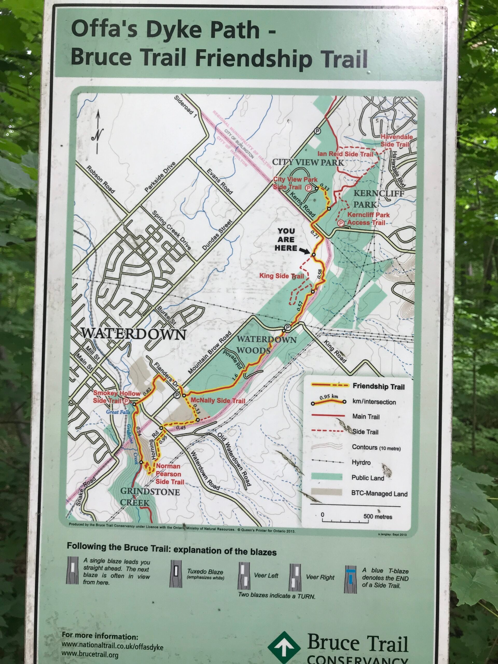
Friendship Trail (City View Park to Grindstone Creek Loop)
https://hikesstaging.brucetrail.org/event/friendship-trail-city-view-park-to-grindstone-creek-loop-2/Sorry, the registration cut-off time for this hike has been reached.Not a member? Click here to join today!Hosting Club: Iroquoia
Category: General Hike
Location (Google Maps): Meet at City View Park parking lot (South Entrance), Burlington. Located just south of Hwy #5 off of Kerns Rd.Hike Leader(s): Karen Capindale-Smith Click here to contact Hike Leader(s)
Pace: Medium – 3 to 4 km/hr
Terrain: Strenuous – Hilly with steep climbs and some poor footing
Distance: 10km +Description
This 10.5 km hike will follow the main BT along the edge of the escarpment for great views of the Skyway bridge , Lake Ontario and surrounding area. We will continue to the outskirts of Waterdown and down into/out of the Grindstone Creek via the McNally and Waterdown Rd Side trails and main BT. Please dress in layers and bring water and a snack. Icers may be necessary.Expect baked goods 🙂
CANCELLED due to ice storm - Blue Mountains Double Chipper 2of8 (km53.1-61.5 o&b)
https://hikesstaging.brucetrail.org/event/blue-mountains-double-chipper-2of8-km53-1-61-5-ob/Sorry, the registration cut-off time for this hike has been reached.Not a member? Click here to join today!Hosting Club: Beaver Valley
Location (Google Maps): Parking area on the east side of 2nd Line
$fee$
Map 23
Edition 31Hike Leader(s): Kristina Rettie Click here to contact the hike leader.
Pace: Medium
Terrain: Moderate, Some rocky footing, Some steep sections, Strenuous
Length of Hike: 16.8kmDescription
Beaver Valley will be taking a field trip to Blue Mountains! On Tuesdays between April 1st and June 10th we will chip away in a series of 8 hikes that will cover 2 E2E’s of Blue Mountains. These hikes will be out and backs ranging between 14km and 22kms (1 Being 6km). You are welcome to sign up for as many or as little as you like. Please be respectful and only sign up to the hikes you can make a commitment to. Please keep track of your own hikes as each hiker will submit their own badge request. These hikes are not in order so be sure to check the title and description for the section that will be covered on any given Tuesday.These hikes are listed at a medium pace. We will keep a consistent hiking pace of around 4km/hr with time to take in all the beautiful features Blue Mountains has to offer.
Check the weather and dress for the day. Be sure to bring plenty of water and snacks.
We will take a clothing adjustment break around 2km in and then a snack break around half way.
Please bring icers as we may still have ice/snow in some areas on the trail.
For morning of cancellations please text Kristina @ 519-410-9077
Humber Valley - Glen Haffy Side Trail
https://hikesstaging.brucetrail.org/event/humber-valley-glen-haffy-side-trail/Sorry, the registration cut-off time for this hike has been reached.Not a member? Click here to join today!Hosting Club: Dufferin Hi-Land
Category: Tuesday Hike
Location (Google Maps): Caledon Hills, Map 18. Meet at 7th Line BTC parking lot about 1.5 km north of Hwy 9 (near Km 43.3) . Entrance to the lot is just off of Airport Rd on 7th Line, Mono.Hike Leader(s): Tony Evangelista; Les Babbage; Inge Eckerich; Julie Daley Click here to contact Hike Leader(s)
Pace: Leisurely
Terrain: Moderate
Distance: 7 or 3.6 kmDescription
We will hike the Main Trail south to the Glen Haffy Side Trail, then follow the side trail east as far as the Mono Adjala Townline and back. The shorter hike will turn back at the intersection of the two trails.Cancelled: Noisy River Provincial Nature Reserve
https://hikesstaging.brucetrail.org/event/noisy-river-provincial-nature-reserve/Sorry, the registration cut-off time for this hike has been reached.Not a member? Click here to join today!Hosting Club: Dufferin Hi-Land
Category: Cancelled
Location (Google Maps):(Google Maps) Blue Mountain Section, Map 21. Meet at roadside parking at Km 54.9 on Mulmur-Nottawasaga Townline, 550 metres east of Lavender Hill Road at the cemetery at 9:30 am or at the SuperBurger parking lot (north-west corner of Hwy 89/Hwy 10 intersection) for car pooling at 9:00 am.
Hike Leader(s): Les Babbage, Inge Eckerick, Julie Daley, Tony Evangelista Click here to contact Hike Leader(s)
Pace: Leisurely, Medium
Terrain: Moderate, Slippery Sections Likely
Distance: Long Hike 6.6 km Short hike 4 kmDescription
From the Lavender cemetery we will shuttle to roadside parking on County Rd 9 at Km 6.1. We will then hike back through the scenic Noisy River Provincial Nature Reserve to the small, but historic, village of Lavender, where the Dufferin Hi-Land Section ends. The shorter hike will turn around and return to County Rd 9 parking after about 2 km. Bring water and snacks. Hiking poles are recommended. Icers may be required.Boston Mills / Terra Cotta
https://hikesstaging.brucetrail.org/event/boston-mills-mississauga-rd-3/Sorry, the registration cut-off time for this hike has been reached.Not a member? Click here to join today!Hosting Club: Caledon Hills
Category: Tuesday Hikers
Location (Google Maps): Parking at Boston Mills Rd., just west of its intersection with Mississauga Rd. See Map 14.
Driving directions: From Highway 410 north, continue on Highway 10, left on King Street, right on Mississauga Rd., left on Boston Mills Rd. to the parking at dead end.Hike Leader(s): Mohammad Shafiq Click here to contact Hike Leader(s)
Pace: Medium – 3 to 4 km/hour
Terrain: Moderate – some hills and/or some poor footing
Distance: 12 kmDescription
Main Bruce Trail and Rockside Trail, there and back; will hike about 6 km reaching into Terra Cotta and return after snack break.
Bring any drink, snack; poles are recommended.
After hike there is optional stop at nearby coffee place, to be decided.