
Hike Schedule
Join us for a hike! Registration required.
All hikes available to BTC members. Some hikes are open to non-members.
See Refund Policy for Paid Hikes >
TIP: The calendar view displays up to 7 hikes on a day, but often there are more. Click “View more events” to see them all.
Categories
- 02April 2, 2025
Sydenham E2E 2/8
https://hikesstaging.brucetrail.org/event/sydenham-e2e-2-8/Sorry, the registration cut-off time for this hike has been reached.Not a member? Click here to join today!Hike open to BTC Members only.
Hosting Club: Toronto
Category: Car Hike
Location (Google Maps): Same as day 1.Hike Leader(s): Smadar Junkin Click here to contact Hike Leader(s)
Pace: Brisk (4-5 km/hr)
Distance: 21 km
Description
Please see instructions on hike #1, April 1. We will shuttle to km 41.7 and hike back.Wednesday Walkers - Mud Free Urban Walk Collingwood Cancelled
https://hikesstaging.brucetrail.org/event/wednesday-walkers-mud-free-urban-walk-collingwood/Sorry, the registration cut-off time for this hike has been reached.Not a member? Click here to join today!Hosting Club: Beaver Valley
Location (Google Maps): Meet in the parking area behind MacDonald’s.
Hike Leader(s): Glenda Collings Click here to contact the hike leader.
Pace: Medium
Terrain: Easy
Length of Hike: 1 1/2 hoursDescription
April is a muddy time of year on our Beaver Valley Trail, so let’s get out on some urban walks this month, have some exercise and enjoy the camaraderie we find with group walks. Dress appropriately for the weather and bring water, In Collingwood we’ll take in the waterfront and some of the city’s trail system.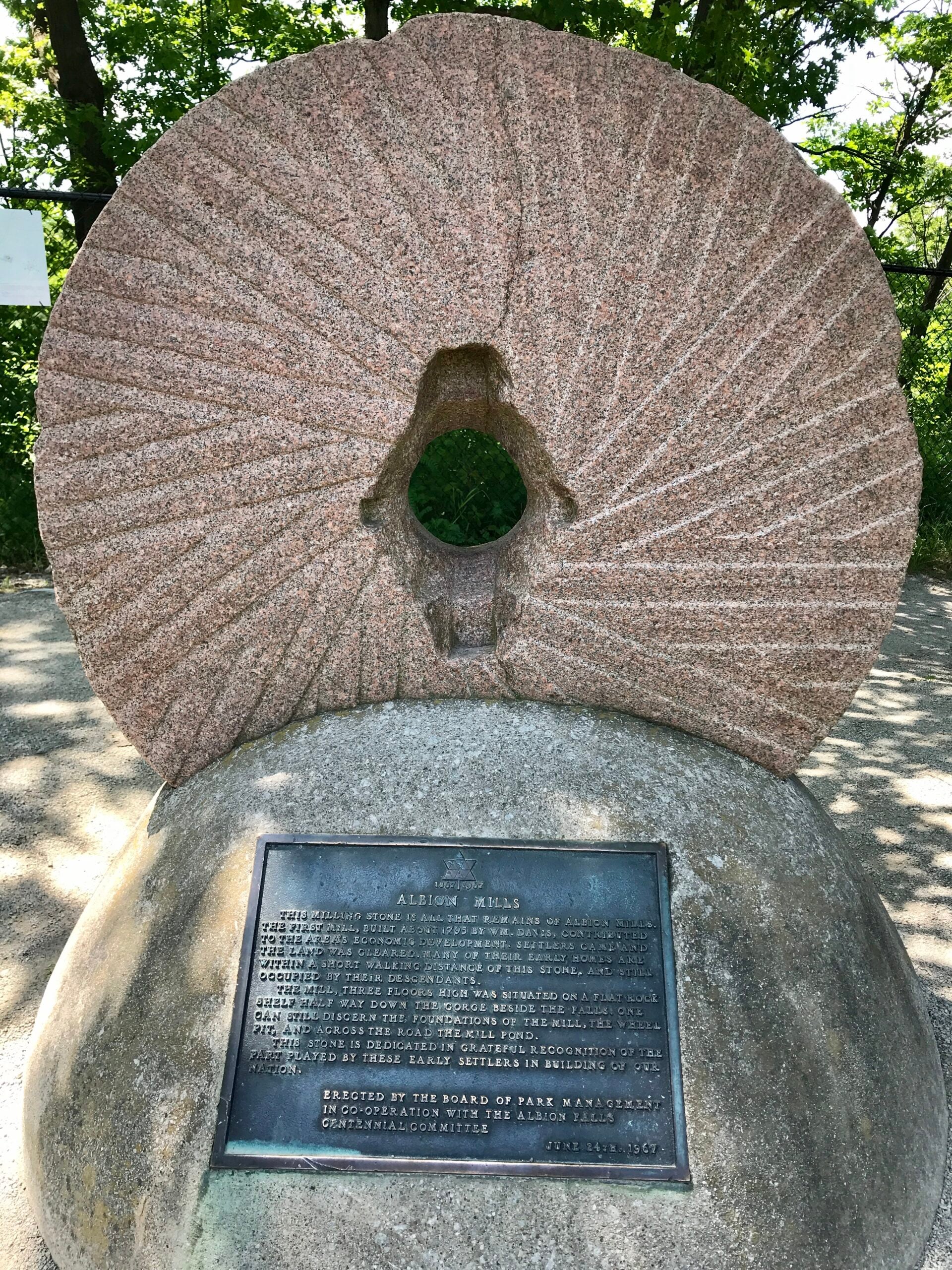
Rail Trail and Mountain Brow (with Albion Falls)
https://hikesstaging.brucetrail.org/event/rail-trail-and-mountain-brow-with-albion-falls/Sorry, the registration cut-off time for this hike has been reached.Not a member? Click here to join today!Hike open to BTC Members only.
Hosting Club: Iroquoia
Category: Good Companions
Location (Google Maps):Red Hill Valley Trail South Parking Lot – Mud Street Just beyond where Mountain Brow Blvd meets Pritchard Rd on the east mountain area of Hamilton See map below
Hike Leader(s): Ted Bossence Click here to contact Hike Leader(s)
Pace: Medium – 3 to 4 km/hr
Terrain: Easy – Mostly flat and usually good footing
Distance: 8 kmDescription
After traversing the south side of Albion Falls we will follow the rail trail until we reach the Margate stairs. We will Ascend the 159 stairs to the top of the escarpment and then follow the paved path and then the blue side trail past Buttermilk Falls and Albion Falls and arriving back at the parking lot.Please arrive by 9:45 am as we will be on the trail by 10:00 am sharp. Bring water and a snack. Icers if necessary (hopefully not!)
If cancelled due to rain (snow?), I will notify you by email the evening prior to the hike. If you cancel after 4:00 pm on the day prior to the hike, use the contact information I will send you by email a day or two before the hike.
Evening Hike in Owen Sound followed by an Opportunity for Refreshments
https://hikesstaging.brucetrail.org/event/evening-hike-in-owen-sound-followed-by-an-opportunity-for-refreshments-14/Sorry, the registration cut-off time for this hike has been reached.Not a member? Click here to join today!Hosting Club: Sydenham
Category: An evening walk.
Location (Google Maps): Municipal parking lot by the river on the West side of 1st Ave East between 7th St East and 8th St East in Owen SoundHike Leader(s): Harriet Nixon Click here to contact Hike Leader(s)
Pace: Brisk: 4 to 5 km/h
Terrain: Moderate: Some hills and/or poor footing
Distance: Approx 5 kmDescription
Join us for a brisk spring evening hike exploring the paths and neighbourhoods of Owen Sound, followed by an opportunity to socialize at one of the local establishments. There is no need to show up 15 minutes early for this hike, but we will leave promptly at 7:00 pm. - 03April 3, 2025
Urban Walk:: Valley View Park Thornhill
https://hikesstaging.brucetrail.org/event/urban-walk-valley-view-park-thornhill-59/Sorry, the registration cut-off time for this hike has been reached.Not a member? Click here to join today!Hosting Club: Toronto
Location (Google Maps): Parking lot is inside Sycamore Drive East of Bayview , north of Bayview Reservoir Park Playground, across Starbucks plaza
Hike Leader(s): Mohammad Aghamiri Click here to contact Hike Leader(s)
Pace: Moderate (3-4 km/hr)
Terrain: Hilly, Level 2 (Intermediate – some hills and uneven surfaces, rocks and roots underfoot)
Distance: 7-8 kmDescription
We will explore Valleyview and Maple View parks, and walk along German Mill Creak, in return we stop in Huntington park and have snack under beautiful shed ,Even it is considered Urban walk, it is urban hike as we have some up and down hills and tree roots, please bring your hiking poles, water and snacks
9:00 am Long Hike Cave Spring
https://hikesstaging.brucetrail.org/event/900-am-long-hike-cave-spring-9/Sorry, the registration cut-off time for this hike has been reached.Not a member? Click here to join today!Hosting Club: Niagara
Category: In and Out
Location (Google Maps):Cave Spring Conservation Area
Hike Leader(s): Alan Laver Click here to contact Hike Leader(s)
Pace: Medium
Terrain: Moderate
Distance: 10kDescription
From Cave Spring Conservation Area explore the trail network on the escarpment You must register for each hike. Bring Poles, snack and a drink and dress for the weatherHiking around Jordan
https://hikesstaging.brucetrail.org/event/hiking-around-jordan-29/Sorry, the registration cut-off time for this hike has been reached.Not a member? Click here to join today!Hosting Club: Niagara
Location (Google Maps): Shoarishon Park (formerly known as Jordan Hollow)
Note: Due to construction at Shoarishon Park, Boo’s Restaurant across the street is allowing us to use their premises to park
Hike Leader(s): Bill Russell Click here to contact Hike Leader(s)
Pace: Medium
Terrain: Moderate
Distance: 6 – 7 kmDescription
Hike various trails in and around Jordan (Balls Falls, Jim Rainforth Trail, Bailey’s Bridge and through the village of Jordan - 04April 4, 2025

End-to-End Makeup Hike in 8: Wiarton Bluewater Park to Jones Bluff ST parking area
https://hikesstaging.brucetrail.org/event/end-to-end-makeup-hike-in-8-wiarton-bluewater-park-to-jones-bluff-st-parking-area/Sorry, the registration cut-off time for this hike has been reached.Not a member? Click here to join today!Hike open to BTC Members only.
Hosting Club: Peninsula
Category: Peninsula E2E
Location (Google Maps): Jones Bluff ST parking areaHike Leader(s): Shawn Radcliffe Click here to contact Hike Leader(s)
Pace: Medium (3.0 – 4.5 km/h): A comfortable pace for most hikers with steady progress.
Terrain: Difficult: Steep ascents/descents, rocky scrambling, and some rugged escarpment paths., Moderate: Rolling hills, mild slopes and rocky paths.
Distance: 25.1Description
Expectations: Expect to be on-trail for 7-9 hours each day, depending on the daily distance. Time on the trail may vary based on terrain, conditions, and the pace of the group. Breaks will be taken for lunch, snacks, photography, and to appreciate the scenery.Meeting Time: Please arrive no later than 15 minutes prior to the scheduled time.
Participant Requirements:
- Intermediate/experienced hikers, comfortable with longer distances and elevation gains.
- Must be physically fit for group hiking.
- Proper hiking boots, layered clothing, and wet weather gear required. Hiking poles recommended.
- Essentials: Lunch, snacks, water, bug spray.
- Breaks for photography and appreciation of local flora and fauna.
Car Shuttle: Ensure your vehicle is passenger-ready.
Accommodations: Early reservations recommended, especially near meeting points or in Lion’s Head. Suggested options: motels, campgrounds, hostels, and B&Bs.
Sydenham E2E 4/8
https://hikesstaging.brucetrail.org/event/sydenham-e2e-4-8/Sorry, the registration cut-off time for this hike has been reached.Not a member? Click here to join today!Hike open to BTC Members only.
Hosting Club: Toronto
Category: Car Hike
Location (Google Maps): Same as day 3.Hike Leader(s): Smadar Junkin Click here to contact Hike Leader(s)
Pace: Brisk (4-5 km/hr)
Terrain: Rocky, Variable
Distance: 18.8Description
Fourth hike to complete the Sydenham E2E. Please see instructions on hike #1. April 1.we will shuttle to km 86.7 and walk back.please note that the difference between the km markers of the map and the distance are different because of a shorter trail due to a reroute.
9:00am Niagara Shores Park Beachcoming Hike
https://hikesstaging.brucetrail.org/event/900am-niagara-shores-park-beachcoming-hike-4/Sorry, the registration cut-off time for this hike has been reached.Not a member? Click here to join today!Hosting Club: Niagara
Category: Loop
Location (Google Maps):Corner of Niven Road and Lakeshore Road in Niagara-on-the-Lake. Park along Old Lakeshore Road.
Hike Leader(s): Suzanne Gourluck Click here to contact Hike Leader(s)
Pace: Leisurely
Terrain: Moderate
Distance: 5-6kmDescription
Explore a lakeshore park, shoreline and cliff top trail in Niagara-on-the-Lake. This beachcombing hike involves uneven ground, clambouring over fallen trees, a pebbly beach, sandy, wet and exposed areas. Hat, Icer’s and poles are highly recommended. Please note: This is not a maintained trail so caution is needed.
9:00 am Niagara-on-the-Lake Tour
https://hikesstaging.brucetrail.org/event/900-am-niagara-on-the-lake-tour-37/Sorry, the registration cut-off time for this hike has been reached.Not a member? Click here to join today!Hosting Club: Niagara
Category: Urban
Location (Google Maps):Veterans Memorial Park, park just outside the park on King Street
Hike Leader(s): Robin Garrett Click here to contact Hike Leader(s)
Pace: Medium
Terrain: Easy
Distance: 6-7 kmDescription
Each Friday we will explore different neighbourhoods, trails and parkland throughout Historic Niagara-on-the-Lake.Moderate pace with some weeks entirely on sidewalks and roads while others may include a mix of trails and paved pathways. Great way to build up endurance for longer more strenuous hikes.
Prepare for cooler windy conditions on open parkland and along Lake Ontario and Niagara River trails.
Plan to stay for conversation and a warm cup of coffee or tea at Sweets & Swirls, Community Centre, Niagara Stone Road, NOTL

Cityview Park
https://hikesstaging.brucetrail.org/event/cityview-park-3/Sorry, the registration cut-off time for this hike has been reached.Not a member? Click here to join today!Hosting Club: Iroquoia
Category: General Hike
Location (Google Maps): Meet at Cityview Park, 2nd parking lot on Kerns RoadHike Leader(s): Karen Bergmann Click here to contact Hike Leader(s)
Pace: Medium – 3 to 4 km/hr
Terrain: Moderate – Some hills and/or some poor footing
Distance: 8 kmsDescription
Hiking the bike trails, side trails and main trail to Waterdown and back for a good loop. Mostly good footing with some rocky sections on the main trail. Bring icers. Hike is dependent on weather. - 05April 5, 2025

End-to-End Makeup Hike in 8: Jones Bluff ST parking area to Hope Bay
https://hikesstaging.brucetrail.org/event/end-to-end-makeup-hike-in-8-jones-bluff-st-parking-area-to-hope-bay/Sorry, the registration cut-off time for this hike has been reached.Not a member? Click here to join today!Hike open to BTC Members only.
Hosting Club: Peninsula
Category: Peninsula E2E
Location (Google Maps): Hope BayHike Leader(s): Kathleen Stahlbaum Click here to contact Hike Leader(s)
Pace: Medium (3.0 – 4.5 km/h): A comfortable pace for most hikers with steady progress.
Terrain: Difficult: Steep ascents/descents, rocky scrambling, and some rugged escarpment paths., Moderate: Rolling hills, mild slopes and rocky paths.
Distance: 19.2Description
Expectations: Expect to be on-trail for 7-9 hours each day, depending on the daily distance. Time on the trail may vary based on terrain, conditions, and the pace of the group. Breaks will be taken for lunch, snacks, photography, and to appreciate the scenery.Meeting Time: Please arrive no later than 15 minutes prior to the scheduled time.
Participant Requirements:
- Intermediate/experienced hikers, comfortable with longer distances and elevation gains.
- Must be physically fit for group hiking.
- Proper hiking boots, layered clothing, and wet weather gear required. Hiking poles recommended.
- Essentials: Lunch, snacks, water, bug spray.
- Breaks for photography and appreciation of local flora and fauna.
Car Shuttle: Ensure your vehicle is passenger-ready.
Accommodations: Early reservations recommended, especially near meeting points or in Lion’s Head. Suggested options: motels, campgrounds, hostels, and B&Bs.
Car Hike: East Point Park Bird Sanctuary, Scarborough, ON 181
https://hikesstaging.brucetrail.org/event/car-hike-east-point-park-bird-sanctuary-scarborough-on-2/Sorry, the registration cut-off time for this hike has been reached.Not a member? Click here to join today!Hosting Club: Toronto
Location (Google Maps): East Point Park Bird Sanctuary, Scarborough, ON
parking lot at the end of Beech grove Dr.Hike Leader(s): Mohammad Aghamiri Click here to contact Hike Leader(s)
Pace: Moderate (3-4 km/hr)
Terrain: Flat
Distance: 12-14 kmDescription
We will hike along lake Ontario to Scarborough Bluffs.Please bring hiking poles, proper closing and shoes and lots of smile,
School Bus Hike: Niagara E2E #1 of 6
https://hikesstaging.brucetrail.org/event/niagara-section-e2e-1-of-6/Sorry, the registration cut-off time for this hike has been reached.Not a member? Click here to join today!Trip Information
Departure Time: 08:30
Return to City Time: 18:00
Departure Point: Kipling Departure PointOptional Items
Hosting Club: Toronto
Category: Bus Hike
Location (Google Maps): Niagara Section Kms 0.0 to 13.3Hike Leader(s): Tim Wainwright, Felix Wan Click here to contact Hike Leader(s)
Pace: Moderate (3-4 km/hr)
Terrain: Level 2 (Intermediate – some hills and uneven surfaces, rocks and roots underfoot), Variable
Distance: 13.3 kmDescription
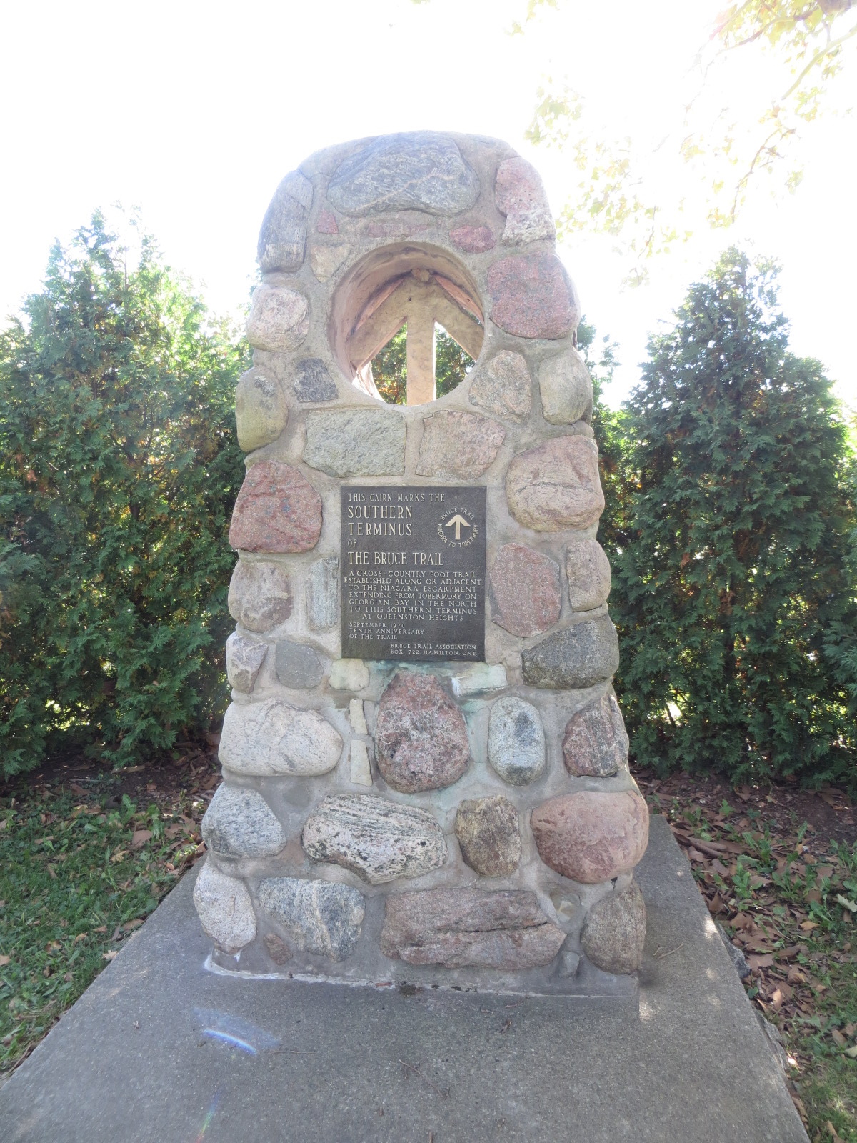
Join us for the kick-off hike of a 6 part end-to-end of the Niagara section. Our route starts at the cairn marking the southern terminus of the Bruce Trail (km 0.0, only 900 kms more to Tobermory!), in Queenston Heights Park. After passing through the park, we’ll walk along the brow of the escarpment and then follow the trail to our drop-out point at Firemen’s Park at km 7.0. Further along the way we’ll encounter the “Screaming Tunnel” underpass on our way to our ending point in the Woodend Conservation Area at km 13.3.Bring icers, a packed lunch, 2 litres of water, and sun/rain/bug protection as needed.
This hike is covered on Maps #1-2 of the Bruce Trail Reference Guide.
We will have a refreshment stop before heading back to Toronto.
The other dates for the Niagara End to End will be
2. April 19
3. May 10
4. May 17
5. May 24
6. June 7Car Hike: Hockley Valley Provincial Nature Reserve
https://hikesstaging.brucetrail.org/event/car-hike-hockley-valley-provincial-nature-reserve/Sorry, the registration cut-off time for this hike has been reached.Not a member? Click here to join today!Hosting Club: Caledon Hills
Category: General
Location (Google Maps): Hockley Valley Provincial Nature Reserve, Map 18. To reach the meeting point, drive north on Hwy 10 from Orangeville and turn right onto Hockley Road. Continue approximately 5 km east until you see the parking area on your left, directly across the road from the Black Birch restaurant.Hike Leader(s): Dylan “Lana” Hubbard Click here to contact Hike Leader(s)
Pace: Medium – 3 to 4 km/hour
Terrain: Strenuous – hilly with steep climbs and some poor footing
Distance: 15 kmDescription
Join us for a 14 km hike through the Nature Reserve, known for being one of the most challenging and hilly sections of the Bruce Trail. Get ready for a workout.We will be hiking at a moderate pace and please bring icers.
We are committed to providing an inclusive and welcoming environment. This hike is an 2SLGBTQIA+ safe space, and everyone is welcome to join us!

Saturday Shorts: Hockley Valley South Citizen Scientist Nature Walk
https://hikesstaging.brucetrail.org/event/saturday-shorts-hockley-valley-south-citizen-scientist-nature-walk/Sorry, the registration cut-off time for this hike has been reached.Not a member? Click here to join today!Hosting Club: Caledon Hills
Category: Nature Walks
Location (Google Maps): Meet at the BTC parking lot on the east side of the 5th Line EHS, just south of Hockley Road, 43.993572, -80.014057.Driving Directions:
From ON-10, turn east onto Hockley Road/Dufferin County Road 7. Drive for 9.5 kilometres. Turn south/right onto 5 Line E/5th Line EHS. The parking lot is on the left in 100 metres.Hike Leader(s): Sandy Green Click here to contact Hike Leader(s)
Pace: Leisurely – 3 km/hour or less
Terrain: Strenuous – hilly with steep climbs and some poor footing
Distance: 5.5 kmDescription
Pique your curiosity about the awakening forest in the Hockley Valley south area. Learn to use nature identification apps Merlin, Seek and iNaturalist to collect biodiversity data along the Bruce Trail for the BTC’s iNaturalist Project. Badge seekers can work towards earning the CHBTC Citizen Scientist badge.Cancelled due to ice storm - Dufferin Hi-Land 60th Anniversary Side Trail Highlights
https://hikesstaging.brucetrail.org/event/dufferin-hi-land-60th-anniversary-side-trail-highlights-7/Sorry, the registration cut-off time for this hike has been reached.Not a member? Click here to join today!Hosting Club: Dufferin Hi-Land
Category: Cancelled
Location (Google Maps): Park at Split Rock Narrows parking lot on 2nd Line EHS, 1.5 km north of 25 Sideroad (north of Mono Cliffs Provincial Park).Hike Leader(s): su Bate Click here to contact Hike Leader(s)
Pace: Brisk
Distance: 10km
Description
RESCHEDULED FROM LAST WEEK. This is the 3rd in a series of 6 loop hikes; each hike is between 9-12km in length. If you hike all 6 of the hikes in this series, or otherwise hike 60 km in Dufferin during 2025, you qualify for the 60th Anniversary badge.Bring a drink, a snack and ICERS. There are some steep drop offs and the trail can be slippery, icy and muddy at this time of year. Dress for the weather!We will follow Splitrock Side Trail east and south to second intersection with Ralph Tremills Side Trail. Then we follow Ralph Tremills east and return via Splitrock Side Trail west to 2ndLine. We’ll follow 2nd Line EHS Side Trail south to 25 Sideroad, cross the stile and continue south on Walter Tovell Side Trail to Clifftop Trail. Keep right on Clifftop Trail to Bruce Main Trail, following the Main Trail west and north to Lookout Side Trail (km 4.0). Take Lookout Trail north and east to Walter Tovell and return north on Walter Tovell and 2nd Line EHS Side Trail to parking lot.