
Hike Schedule
Join us for a hike! Registration required:
All hikes available to BTC members. Some hikes are open to non-members.
TIP: The calendar view displays up to 7 hikes on a day, but often there are more. Click “More events” to see them all.
Categories
- 21September 21, 2024
Car Hike; Bethesda Trail Richmond Hill
https://hikesstaging.brucetrail.org/event/car-hike-bethesda-trail-richmond-hill-21/Sorry, the registration cut-off time for this hike has been reached.Not a member? Click here to join today!Hosting Club: Toronto
Location (Google Maps): Meet at Bethesda Trail Head Parking on Bethesda Sideroad off Bayview Avenue, across from Lake Wilcox. This parking lot is free.
Hike Leader(s): Mohammad Aghamiri Click here to contact Hike Leader(s)
Pace: Moderate (3-4 km/hr)
Terrain: Hilly, Variable
Distance: 14-17 kmDescription
Join us to explore Jefferson Forest and Bond lakePlease bring hiking poles, proper closing and shoes and lots of water,
Car Hike: Boyne Valley Provincial Park! - Cancelled
https://hikesstaging.brucetrail.org/event/car-hike-boyne-valley-provincial-park-2/Sorry, the registration cut-off time for this hike has been reached.Not a member? Click here to join today!Hosting Club: Caledon Hills
Category: General
Location (Google Maps): Boyne Valley Provincial Park, Map 20 of the BTC Trail Guide. County Rd. 19 (Prince of Wales Rd.) Parking Area – west of km 15.2 – approximately 80 metres south of the Prince of Wales Side Trail.Hike Leader(s): Dylan “Lana” Hubbard Click here to contact Hike Leader(s)
Pace: Brisk – 4 to 5 km/hour
Terrain: Strenuous – hilly with steep climbs and some poor footing
Distance: 17 kmDescription
Join us for an invigorating hike starting from the parking lot on Prince of Wales Rd. We’ll explore the Prince of Wales Side Trail, Primrose Loop Side Trail, main trail, and Boyne Valley Side Trail, looping back via the main trail and Prince of Wales Side Trail. Along the way, we’ll hike up the short side trail to Murphy’s Pinnacle, where you’ll be rewarded with a stunning view of the surrounding landscape – great for Instagram!Bring lunch, plenty of water, and hiking poles if you use them, as the trail is hilly. Dress for the weather and note that this hike will happen rain or shine!
This hike is a 2SLGBTQIA+ friendly space. Everyone is welcome to join us for this adventure and enjoy the beauty of the trails together.
Bus Hike: Spencer Gorge & Borer's Falls - CANCELLED Diue To Low Registration
https://hikesstaging.brucetrail.org/event/school-bus-hike-spencer-gorge-borers-falls/Sorry, the registration cut-off time for this hike has been reached.Not a member? Click here to join today!Hosting Club: Toronto
Category: Cancelled
Location (Google Maps): Dundas, ON – Spencer Gorge/Borer’s FallsHike Leader(s): Peter Leeney, Leila Damband Click here to contact Hike Leader(s)
Pace: Moderate (3-4 km/hr)
Terrain: Hilly, Level 2 (Intermediate – some hills and uneven surfaces, rocks and roots underfoot), Other (Refer to Description), Rocky
Distance: 13 km, Dropout at 6kmDescription
We will begin with a visit to Tews Falls then follow the side trail down to the Main Bruce Trail. We will hike north on the Trail past Borer’s Falls and under Hwy 6 to Clappison Woods; then up the Rockcliffe Side Trail to Waterdown.
The terrain will be moderate but there will be some hills and poor footing. Hiking boots are essential. Dropout at 6 km. Difficulty Level: 2 (Intermediate)
Peninsula Blue Series: Malcolm Bluff
https://hikesstaging.brucetrail.org/event/peninsula-blue-series-malcolm-bluff-2/Sorry, the registration cut-off time for this hike has been reached.Not a member? Click here to join today!Hosting Club: Peninsula
Category: Peninsula Blue Series
Location (Google Maps): Bruce Trail parking lot: Near the bend of the road at the junction of Malcolm Bluff Side Trail and Purple Valley Access Trails.Hike Leader(s): Kathleen Stahlbaum Click here to contact Hike Leader(s)
Pace: Leisurely, Medium
Terrain: Easy, Moderate
Distance: 11.65 kmDescription
Whether you’ve hiked the area or it’s your first time visiting, make the most of your visit to Malcolm Bluff by checking off not only a significant stretch of main trail, but also a couple side trails in the area!During this hike, we’ll explore some main trail plus a few side trails along the top of Malcolm Bluff – the Purple Valley Access Trail, Bob Light Side Trail, and Malcolm Bluff Side Trail.
We’ll depart for our hike from the Bruce Trail Parking lot on Wright’s Crescent. Our hike will begin along the Purple Valley Side Trail which will bring us to the main trail that follows the top of the soaring cliffs of Malcolm Bluff. Malcolm Bluff, the top of the aptly named Malcolm Bluff Shores Nature Reserve offers panoramic views of Whitecloud Island, Griffith Island, and Hay Island with gorgeous views of the lush tree canopy below. On a clear day, you can even see as far as the Blue Mountains of Collingwood!
We’ll hike just under 5 km of main trail before meeting the Bob Light Side Trail which is named after a long-serving Peninsula volunteer and donor. We’ll follow the blue blazes of the Bob Light Side Trail to the Malcolm Bluffs Side Trail, and walk through hardwood forest to eventually meet our final stretch along Wright’s Crescent, a gravel road that will bring us back to our vehicles.
The trail is rated easy, relatively flat with the usual roots and rocks the Bruce Trail is known for! Good balance and proper footwear are necessary, trekking poles are optional. Rain gear may come in handy. Pace will be leisurely to moderate and adjusted for slippery conditions, if needed. Bring plenty of water for hydration, plus a light lunch and a snack or two to keep you nourished throughout our ~5 hour adventure!

Hope Bay Loop - PBTC Trail Running Pilot #1
https://hikesstaging.brucetrail.org/event/hope-bay-loop-pbtc-trail-running-pilot-1/Sorry, the registration cut-off time for this hike has been reached.Not a member? Click here to join today!Hosting Club: Peninsula
Location (Google Maps): Meet up at Hope Bay Public Parking Lot, 10 Hope Bay Rd. Map 37 (Bruce Trail Reference Guide 30th Edition).
Hike Leader(s): Margie Gloade Click here to contact Hike Leader(s)
Pace: Fast
Terrain: Difficult
Distance: 10KDescription
The PBTC is excited to pilot two trail runs as part of their hiking series. These fall 2024 pilot trail runs will help with preliminary plans for a Peninsula E2E trail running series in 2025. The first trail run on Saturday, Sept.21, 2024, will be a 10k loop of Hope Bay Forest Provincial Nature Reserve starting in the Hope Bay public parking lot. The loop will include 2.7k from the parking lot, north on Water Street into the trail to the Jack Poste Side Trail. We will turn clockwise (north) on the Jack Poste Side Trail to the Don Irish Side Trail and back along the main trail for about a 4k loop; then back on the main trail to the parking lot for a total of about 10k. This is not a race. Trail runners will be expected to stay together – plan for approximately 2 hours. This is technical terrain for running. You should have some experience running trails, proper footwear, carry your own water/fuel, and fitness to maintain a jogging pace. Car pool if possible. Please join this run and share your feedback for future PBTC trail running events!Sydenham Series #9- Kemble Mountain to Skinner's Bluff
https://hikesstaging.brucetrail.org/event/sydenham-series-9-kemble-mountain-to-skinners-bluff/Sorry, the registration cut-off time for this hike has been reached.Not a member? Click here to join today!Hosting Club: Dufferin Hi-Land
Category: General Hike
Location (Google Maps): Gleason Lake Road at Colpoy’s Range Road where the Curly Harnden Side Trail meets the Len Holley Side Trail. South of km 160.3, BTC Map 35.Hike Leader(s): Stuart Law Click here to contact Hike Leader(s)
Pace: Medium
Terrain: Dependent on Conditions, Moderate, Slippery and Steep Sections, Slippery Sections Likely
Distance: 17.1 kms.Description
Join us on the ninth of our ten Sydenham E2E Series shuttle hikes. Peaceful rural Ontario. Woods. Beautiful, stunning views. The Bruce Trail at its best. Be ready for a flooded road (bring your crocs). Please bring a garbage bag and a change of footwear for the shuttle (we will be muddy) and please be prepared to drive fellow hikers before or after the hike. Please bring a smile, 3L of water, bug spray, a snack and a lunch. Hiking boots mandatory. Poles and gaiters recommended. Please arrive at 8:45 am to be prepared to shuttle at 9:00 am sharp.
Geology Hike #1 - Rocklyn Creek
https://hikesstaging.brucetrail.org/event/geology-hike-1-rocklyn-creek/Sorry, the registration cut-off time for this hike has been reached.Not a member? Click here to join today!Hike open to BTC Members only.
Hosting Club: Sydenham
Category: Geology Hike
Location (Google Maps): CAR SHUTTLE linear hike. Meet at BT roadside parking along St Vincent-Sydenham Townline north of Walters Falls between Sideroad 3 and Holland-Sydenham Townline. We will be taking some cars to start point at Blantyre and then hike west.Hike Leader(s): Carol Graham-Mullin Click here to contact Hike Leader(s)
Pace: Leisurely: 3 km/h or less
Terrain: Easy: Mostly flat and good footing., Moderate: Some hills and/or poor footing, Strenuous: Hilly with steep climbs and some poor footing.
Distance: 7.4 kmDescription
Join Beth Gilhespy and Carol Mullin on a special geology hike exploring the delightful Rocklyn Creek section, with its many dolostone and shale layers, deep forests, historic foundations and rocky outcrops. This is Hike #1 in the Geology Series (1 of 16 hikes). Copies of Beth’s book, “Walking through Time” will be available for purchase at the end of the hike. A special member’s only price of $37.00 , cash, cheque or etransfer. More details to come about the Sydenham Bruce Trail Geology Badge!Beginners' "Introductory" Hike
https://hikesstaging.brucetrail.org/event/beginners-introductory-hike/Sorry, the registration cut-off time for this hike has been reached.Not a member? Click here to join today!Hosting Club: Dufferin Hi-Land
Category: Special Events
Location (Google Maps): BTC Map #20 1st Line East, Bruce Trail Parking Lot – Rock Hill. Just east of Whitfield south of 10 Side Road (County Road 17).Hike Leader(s): Brenda Carling, Don Stewart Click here to contact Hike Leader(s)
Pace: Leisurely
Terrain: Easy, Moderate
Distance: 4-5 Km based on hikers abilityDescription
This is an exciting new partnering between the Dufferin County Canadian Black Association (DCCBA) and the Dufferin Hi-Land BTC to specifically introduce members of the DCCBA, BUT OPEN TO ANYONE interested in an introduction to hiking the Bruce Trail. We will be emphasizing the health and wellness benefits to be gained through nature walks, while also touching on the important topics of biodiversity, nature conservancy, trail development and maintenance and any other topic that may arise. IF you are a “beginner” and want to join us, please come prepared by wearing clothing suitable for the weather, wearing sturdy running shoes or sneakers (they may get muddy!) and bring a full re-usable water bottle – water will NOT be provided.NOTE: IF the weather is TOO inclement – a “Rain Date” is set for Saturday September 21.
Car Hike: Hockley Valley Map 18
https://hikesstaging.brucetrail.org/event/car-hike-hockley-valley-map-18-3/Sorry, the registration cut-off time for this hike has been reached.Not a member? Click here to join today!Hosting Club: Toronto
Category: Car Hike
Location (Google Maps): Hockley Valley, Map 18Hike Leader(s): Al Brown Click here to contact Hike Leader(s)
Pace: Moderate (3-4 km/hr)
Terrain: Challenging
Distance: 14 kmDescription
We will hike 14 km through the Nature Preserve, one of the most challenging (hilliest) and scenic parts of the Bruce Trail. Fall colors should be showing. Most of the route is under the forest canopy. After the hike I invite those interested to stop at the Hockley Valley Resort for refreshments.To get to the meeting point drive north of Hwy 10 from Orangeville to Hockley Road. Turn right and go about 5 km east to the parking area on your left. It is across the road from the Black Birch restaurant.
Car Hike: Toronto Bruce Trail Club Biodiversity Fall Fern Identification Hike
https://hikesstaging.brucetrail.org/event/car-hike-toronto-bruce-trail-club-biodiversity-fall-fern-identification-hike/Sorry, the registration cut-off time for this hike has been reached.Not a member? Click here to join today!Hosting Club: Toronto
Category: Car Hike
Location (Google Maps): Please note the meeting location has been changed as of 19/09/2024, Meet: Map 14 38.8 km along 10th line north of 27 sideroad.
The change is to ensure we had some ferns to actually find!!
Toronto Section Map12, Km 17.4 There is parking along the roadside both north and south bound. Where the trail crosses the road. We will meet at the boot brush station. Please be ready to hike at 10:00am.Hike Leader(s): Patricia Lynn McFerran Click here to contact Hike Leader(s)
Pace: Leisurely (2-3 km/hr)
Terrain: Variable
Distance: 4-5kmDescription
Today we are looking for ferns to identify with the help of BTC Ecologist Mara McHaffie.
THis are is diverse and has some wet areas so hopefully we will find some interesting plants. THis is a slow paced look and learn hike. This will be a good opportunity for hikers to collect some of the requirements of the TBTC Naturalist badge. Please bring a light lunch or snacks and lots of water . Cameras and the iNaturalist app on your phone will be handy to record what we are going to see. Last fall I saw some rather interesting fungi in this area too.
This hike will go rain or shine, so dress for the weather. - 22September 22, 2024
First Day of Fall: Hockley Valley
https://hikesstaging.brucetrail.org/event/first-day-of-fall-hockley-valley/Sorry, the registration cut-off time for this hike has been reached.Not a member? Click here to join today!Hosting Club: Caledon Hills
Category: General
Location (Google Maps): Hockley Valley Nature Reserve, Map 18. To reach the meeting point, drive north on Hwy 10 from Orangeville and turn right onto Hockley Road. Continue approximately 5 km east until you see the parking area on your left, directly across the road from the Black Birch restaurant.Hike Leader(s): Dylan “Lana” Hubbard Click here to contact Hike Leader(s)
Pace: Medium – 3 to 4 km/hour
Terrain: Strenuous – hilly with steep climbs and some poor footing
Distance: 15 kmDescription
Join us for a 15 km hike through the Nature Reserve, known for being one of the most challenging and hilly sections of the Bruce Trail. Get ready for a workout. After the hike, those interested are welcome to join me at the Hockley Valley Resort for refreshments.This is also on the first day of fall! woohoo!
We are committed to providing an inclusive and welcoming environment. This hike is an 2SLGBTQIA+ safe space, and everyone is welcome to join us!
Sydenham Series #10- Skinner's Bluff to Wiarton
https://hikesstaging.brucetrail.org/event/sydenham-series-10-skinners-bluff-to-wiarton/Sorry, the registration cut-off time for this hike has been reached.Not a member? Click here to join today!Hosting Club: Dufferin Hi-Land
Category: General Hike
Location (Google Maps): Bluewater Park, Wiarton. BTC Map 35, km 171.6.Hike Leader(s): Stuart Law Click here to contact Hike Leader(s)
Pace: Medium
Terrain: Dependent on Conditions, Slippery Sections Likely, Slippery and Steep Sections, Moderate
Distance: 12.7 kmsDescription
Join us on the last of our 10 Sydenham E2E Series shuttle hikes. The march in to the base of the Bruce Peninsula. Could be some ghosts and coffins. Some road walking. Please bring a garbage bag and a change of footwear for the shuttle (we will be muddy) and please be prepared to drive fellow hikers before or after the hike. Please bring a smile, 3L of water, bug spray, a snack and a lunch. Hiking boots mandatory. Poles and gaiters recommended. Please arrive at 8:45 am to be prepared to shuttle at 9:00 am sharp.
Fall Solstice Rainbow hike
https://hikesstaging.brucetrail.org/event/fall-solstice-rainbow-hike/Sorry, the registration cut-off time for this hike has been reached.Not a member? Click here to join today!Hosting Club: Peninsula
Location (Google Maps): Halfway Log Dump Parking Lot, Bruce Peninsula National Park
Hike Leader(s): Marg Glendon, Pat Turner, Madie Barker Click here to contact Hike Leader(s)
Pace: Leisurely, Medium
Terrain: Difficult, Moderate
Distance: Two options: ~ 2km or ~6 kmDescription
Join us on a Fall Solstice Rainbow Hike for 2SLGBTQ+ folx and allies at Halfway Log Dump. Here, the Bruce Trail winds through the beautiful Bruce Peninsula National Park. We will gather at the entrance to Halfway Log Dump Side Trail . Our first 1 km of hiking will be on generally flat terrain bringing us to the pristine, aquamarine water of the Georgian Bay shoreline. Here we will take time to enjoy the view and soak in the early signs of Fall, have lunch, relax, explore the shore and the sights, sounds and feel of Fall. Then, for those wishing to explore the more rugged section of the trail, we will continue north traversing over a boulder beach and some demanding terrain. Good balance and stamina is required for walking this section of the trail. This out and back hike portion of the afternoon will be about 1 ½ hour in duration. Upon returning to the rest of the group at the shoreline, we will take a few minutes to share our experiences with one another. If participants would like to linger longer, the rest of the group will say goodbye and return to our vehicles via Halfway Log Dump Sidetrail. In total, our hiking afternoon will take about 3 ½ hour. Outdoor compost toilets are available at the parking lot and at the shoreline. Bruce Peninsula National Park fees for admission and parking apply. No parking registration is required at this time of year.Weather can be unpredictable at this time of year. Wear layers.hat, sturdy footwear with good tread and closed toes.
Back pack for snacks and lunch, water bottle, blanket for sitting, hiking poles and binoculars (optional).
Ross McLean loop (Bass Lake)
https://hikesstaging.brucetrail.org/event/ross-mclean-loop-bass-lake-4/Sorry, the registration cut-off time for this hike has been reached.Not a member? Click here to join today!Hosting Club: Sydenham
Category: Hike & Potluck
Location (Google Maps): Meet at Kemble Sarawak United Church, 319940 Kemble Rock Road, Kemble. We will carpool to the trailhead. This is one of three hikes offered before the annual general meeting of Sydenham Bruce Trail Club.Hike Leader(s): Carol Mullin Click here to contact Hike Leader(s)
Pace: Leisurely: 3 km/h or less
Terrain: Moderate: Some hills and/or poor footing
Distance: 3.9 km loopDescription
Please arrive by 1:30 pm to sign up for this hike. We will enjoy a picturesque view of Bass Lake and the wetlands along with crevices and a beautiful display of walking fern.Our annual general meeting and potluck supper to follow the hike.
Dodd's Hill and Tumbled Rocks loops
https://hikesstaging.brucetrail.org/event/dodds-hill-and-tumbled-rocks-loops/Sorry, the registration cut-off time for this hike has been reached.Not a member? Click here to join today!Hosting Club: Sydenham
Category: General Hike
Location (Google Maps): Parking lot behind the Kemble Sarawak United Church at the main intersection (Kemble Rock Rd. and Conc. 20) in KembleHike Leader(s): Bill Snel Click here to contact Hike Leader(s)
Pace: Leisurely: 3 km/h or less
Terrain: Moderate: Some hills and/or poor footing, Strenuous: Hilly with steep climbs and some poor footing.
Distance: 3.7 kmDescription
This is one of the hikes that are part of the Annual General Meeting of the Sydenham Club. We will carpool to the top of the escarpment and do the two loop hikes. Because the Tumbled Rocks loop terrain is rougher, hikers will have the option to skip that portion and return to their car on their own. For those who are still doing the hikes and secrets in Exploring Sydenham (hike 42 and 43) and / or Secrets of Sydenham (hike 26 Johannes / Johnson) please remember to bring your book.AGM Hike - Mystery Cabin Loop
https://hikesstaging.brucetrail.org/event/agm-hike-mystery-cabin-loop/Sorry, the registration cut-off time for this hike has been reached.Not a member? Click here to join today!Hosting Club: Sydenham
Category: General Hike
Location (Google Maps): Meet at Kemble Sarawak United church in Kemble at 13:30h and we will car pool to the hike start from there.Hike Leader(s): Fran Turner Click here to contact Hike Leader(s)
Pace: Leisurely: 3 km/h or less
Terrain: Moderate: Some hills and/or poor footing
Distance: 3.6 kmDescription
We will explore three different trails in one hike. We start on the Don Richards Side Trail which leads through a beautiful open meadow before entering the woods. We’ll then hike a section of the main trail, through a shaded forest. We’ll return on the Mystery Cabin Side Trail, which runs at the foot of a rocky cliff face, with gorgeous views out over the valley, as well as towering cliffs overhead. We’ll pass by the remains of an old setter’s cabin, the so-called “Mystery Cabin” It’s a delightful hike!
Urban Walk: Beach side views along the Pickering and Rouge waterfronts
https://hikesstaging.brucetrail.org/event/urban-walk-beach-side-views-along-the-pickering-and-rouge-waterfronts/Sorry, the registration cut-off time for this hike has been reached.Not a member? Click here to join today!Hosting Club: Toronto
Category: Urban Walk
Location (Google Maps): We will meet at the Pickering Go station on the south side. If coming from Toronto Union Station, take the Lakeshore East Go train towards Durham College, Oshawa. The 6th stop is the Pickering Go (~45 minutes train trip).
The latest train you should take is the 13:50 – 14:32 so you are on time for the briefing 15 minutes before the departure time at 3 PM. Trains depart from Toronto Union every 30 minutes.Hike Leader(s): KJ Chong Click here to contact Hike Leader(s)
Pace: Moderate (3-4 km/hr)
Terrain: Level 1 (Easy – mostly on flat, well maintained trails with hard-packed surface), Variable
Distance: 9 kmDescription
Join me for a delightful stroll by the Pickering and Rouge waterfronts. We will pass boardwalks with bridges, pretty neighbourhoods and take in views of two different beaches along Lake Ontario. We will also have a great view of the cliffs around Rouge Beach. The walk also features a few discussion stops regarding biodiversity, wetlands and sand dunes, and invasive species. We will also catch a glimpse of the Pickering Nuclear Power Plant producing clean energy, and discuss the role that nuclear is playing in fighting climate change.The official hike ends at Rouge Hill GO station, where you can either catch the GO train back to Toronto Union Station or you can take the GO train east one-stop towards Pickering GO station. For those interested, we can also continue with a 10 minute walk to visit a local restaurant for a sushi dinner at Azumi Sushi. Plenty of washroom stops too.
Terrain is mostly on tarmac, with one hill as we pass through Petticoat Creek Conservation Park.
Pickering GO station has free parking and so if you were coming by car to meet us, you can also park there.
- 23September 23, 2024
Hike 3 of 7 - Caledon Hills E2E
https://hikesstaging.brucetrail.org/event/hike-3-of-7-caledon-hills-e2e/Sorry, the registration cut-off time for this hike has been reached.Not a member? Click here to join today!Hosting Club: Caledon Hills
Category: End-to-End
Location (Google Maps): Meet at 9:15 at Innis Lake Rd. north of Finnerty Sideroad.
Shuttle to Willoughby Rd.Hike Leader(s): Jennie Greenfield Click here to contact Hike Leader(s)
Pace: Medium – 3 to 4 km/hour
Terrain: Moderate – some hills and/or some poor footing, Strenuous – hilly with steep climbs and some poor footing
Distance: 15.6 kmDescription
Hike 3 of 7 – Caledon Hills E2E.Lots of road walking. Will pass through a tunnel under Hurontario (Hwy 10) with lots of views towards Toronto and Lake Ontario before turning North on Airport Road.
15.9 to 31.5 = 15.6 km (Edition 31)
This hike can be logged towards the “60 for 60th Anniversary” badge
Summer Fen Series: Oliphant Fen
https://hikesstaging.brucetrail.org/event/summer-fen-series-oliphant-fen-2/Sorry, the registration cut-off time for this hike has been reached.Not a member? Click here to join today!Hike open to BTC Members only.
Hosting Club: Sydenham, Peninsula
Category: Botany Hike
Location (Google Maps): Oliphant Fen – by Northern Entrance of the Lorraine Brown BoardwalkHike Leader(s): Jeannine Kralt Click here to contact Hike Leader(s)
Pace: Leisurely: 3 km/h or less
Terrain: Easy: Mostly flat and good footing.
Distance: 2kmDescription
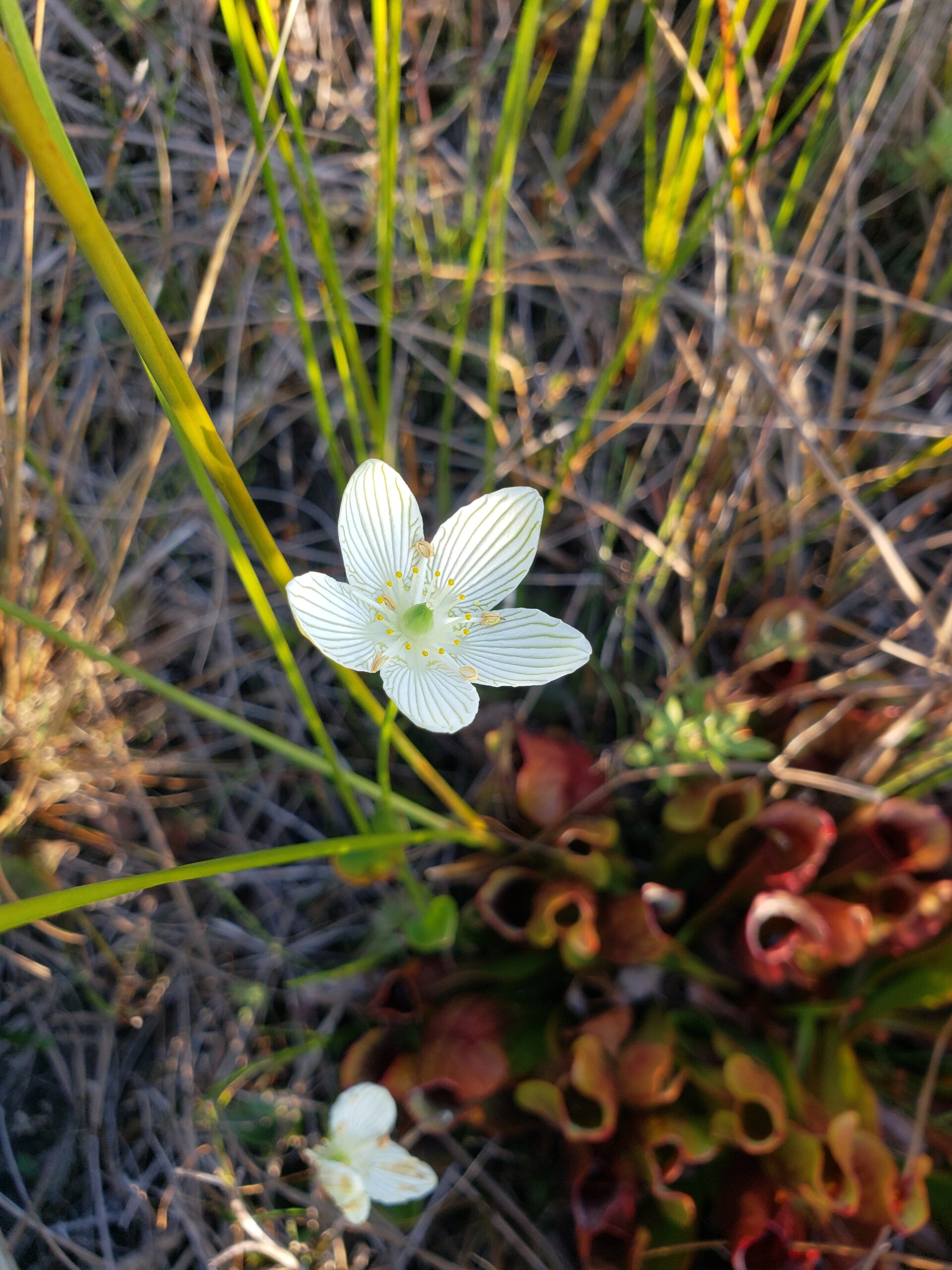
Join the Sydenham and Peninsula Bruce Trail Clubs for a hike series focusing on fens. Fens are unique coastal wetlands occurring along the escarpment, meadow marshes that have conditions that are favourable for a variety of interesting species including orchids.This is the last hike of our easy hiking series, taking place at Oliphant Fen, with a visit to Petrel Point on select dates. Observations count towards the PBTC Orchid Badge.
Come to one of the hikes or several to see how the fens change through the seasons. Carpooling encouraged – contact the hike leader if you are in need of a ride (no guarantees, but attempts will be made to help coordinate). Please plan to arrive 15 minutes in advance of the hike start time.
Please contact Jeannine, the hike leader, if you have any questions or concerns (link on this page).
- 24September 24, 2024
8:00 Long Hike Wiley Road Short Hills
https://hikesstaging.brucetrail.org/event/800-long-hike-wiley-road-short-hills-55/Sorry, the registration cut-off time for this hike has been reached.Not a member? Click here to join today!Hosting Club: Niagara
Location (Google Maps):
Short Hills Wiley Road Entrance
Pace: Medium
Terrain: Moderate
: 10kmDescription
Explore Short Hills and the majestic side trails of Scarlett Tanager, Hemlock. Swayze Falls and Terrace. Register for each hikeBring Poles, Sunscreen, bug spray water, snack, and dress for the weather
Urban hike: Valley View Park Thornhill
https://hikesstaging.brucetrail.org/event/urban-hike-valley-view-park-thornhill-4/Sorry, the registration cut-off time for this hike has been reached.Not a member? Click here to join today!Hosting Club: Toronto
Location (Google Maps): Parking lot at the corner of Bayview Ave, and Sycamore Dr. South of Highway 7
Sycamore Dr. is 3blocks south of highway 7 and 2 blocks north of John Street, parking lot is across plaza of Dollarama and Star boxHike Leader(s): Mohammad Aghamiri Click here to contact Hike Leader(s)
Pace: Moderate (3-4 km/hr)
Terrain: Level 2 (Intermediate – some hills and uneven surfaces, rocks and roots underfoot)
Distance: 7-8 kmDescription
We will explore Valleyview and Maple view parks, and walk along German Mill Creek for approximate 7-8 km. Difficulty Level: 2 (Intermediate)Caledon Hills Section in Six Hikes
https://hikesstaging.brucetrail.org/event/caledon-hills-section-in-six-hikes-2/Sorry, the registration cut-off time for this hike has been reached.Not a member? Click here to join today!Hike open to BTC Members only.
Hosting Club: Caledon Hills
Category: End-to-End
Location (Google Maps): Meet at 9:15 am at Mono 5 Sideroad parking, km 45.4, where the trail crosses. Shuttle to start at Hockley Rd.Hike Leader(s): Elizabeth Ganong Click here to contact Hike Leader(s)
Pace: Medium – 3 to 4 km/hour
Terrain: Moderate – some hills and/or some poor footing, Strenuous – hilly with steep climbs and some poor footing
Distance: 61.1 – 45.4 + 0.250 from parking = 16 km totalDescription
CANCELLED: Due to illness, this hike has been cancelled for September 24th. It will be re-posted soon with a new date. Our apologies.This is the second hike in the series and takes us through the Hockley Valley Resort, pine plantations, hills and valleys.
Please be prepared to help with shuttling hikers at the beginning and at the end of the hike. Bring water and snacks. There will be a break. No dogs please.
Participants who complete all 6 hikes with the co-leaders, Doris Harper and Elizabeth Ganong, will be eligible to purchase the 60th Anniversary End to End badge and the 60 for the 60th Anniversary badge from the hike leaders at the end of the 6th hike. Hike one, a few, or all 6 hikes. Join any hike, complete the rest on your own, and record the hikes in a log. Check the CHBTC website for submission details.
9:15 Short hike - Pelham Road, Short Hills
https://hikesstaging.brucetrail.org/event/915-short-hike-pelham-road-short-hills-84/Sorry, the registration cut-off time for this hike has been reached.Not a member? Click here to join today!Hosting Club: Niagara
Location (Google Maps): Short Hills Provincial Park, Pelham Road entrance
Hike Leader(s): janet davey Click here to contact Hike Leader(s)
Pace: Medium
Terrain: Moderate
Distance: 6 kmsDescription
Hike the main and side trails in Shorthills Provincial Park. Bring hiking boots, water, sunscreen and bug spray. Please help prevent the spread of invasive species by cleaning your boots following the hike. Please check yourself for ticks following the hike.
Beaver Bites #4 of 8
https://hikesstaging.brucetrail.org/event/beaver-bites-4-of-8/Sorry, the registration cut-off time for this hike has been reached.Not a member? Click here to join today!Hosting Club: Beaver Valley
Location (Google Maps): Park on Sideroad 22B at km 95.7, Map 27, ED 31
Hike Leader(s): Kristina Rettie Click here to contact the hike leader.
Pace: Medium
Terrain: Moderate, Some rocky footing, Some steep sections, Strenuous
Length of Hike: 11kmDescription
This is a loop hike that will take us on Fairmount Side Trail, past Webwood Falls then on the mail trail back to our cars.Add on – Mushroom Hunter Badge. Let’s go hunting for mushrooms and other fungi. The magic of the search is in the slowing down and noticing. From the forest floor to trunks of trees, keep a keen eye out as you search for a minimum of 20 different varieties of fungi.
Bring a snack and water
Please no dogs
Text Kristina @ 519-410-9077 for morning of cancellations.
COVID-19 Precautions Before, During and After your Hike
- Each hiker joining a Bruce Trail Club organized hike must perform a self-screening check before hiking.
Find Ontario’s self-assessment tool here: https://covid-19.ontario.ca/self-assessment/ - If you are experiencing COVID-19 symptoms, stay home.
- Personal Protective Equipment:
- Hikers may choose to wear masks
Transportation
It is the Bruce Trail Conservancy’s current policy that car shuttles are allowed. It is at the discrepancy of individual hike leaders to make that decision.
Other Guidelines
- Arrive 15 minutes before the start of the hike.
- Wear sturdy footwear and appropriate attire for the weather and the terrain.
Hiking poles are a good idea in any season, especially if the terrain is rocky or slippery. In winter, snowshoes or icers/crampons are needed when conditions dictate.
Wearing appropriate clothing and footwear prevents injuries and shows consideration for a safe and positive group hiking experience. - Always carry I.D. and your health card.
- Bring sufficient water and snacks (or lunch if indicated). A minimum of 1L of water is recommended on all hikes, and 3L is recommended for long, challenging hikes in the heat of the summer.
- Bring sunscreen and insect repellent (for spring and summer hikes).
- Bring your own first aid kit.
- Please leave dogs at home.
Tuesday Hikes 20 Year Anniversary End-to-End - Hike 2
https://hikesstaging.brucetrail.org/event/tuesday-hikes-20-year-anniversary-end-to-end-hike-2/Sorry, the registration cut-off time for this hike has been reached.Not a member? Click here to join today!Hosting Club: Dufferin Hi-Land
Category: Tuesday Hike
Location (Google Maps):Dufferin Hi-Land Map 19, Km 12.2. Meet at roadside parking on 30 Sideroad Mono about 0.8 km east of Hurontario St.
Hike Leader(s): Inge Eckerich;Les Babbage;Tony Evangelista;Julie Daley Click here to contact Hike Leader(s)
Pace: Leisurely
Terrain: Easy
Distance: 5.4 km; Drop out can be arranged at Km 8.9 for a 2.12 km hike.Description
In 2004 a group of Dufferin Hi-Land BTC members began organizing Tuesday hikes. For their first venture, they hiked a 10 hike/10 week end-to-end series of the DH section. Join us as we recreate this series to celebrate the 20th anniversary of Tuesday hiking and recognize the pioneers who started it all.Hike 2 will take us from 1st Line EHS parking, where the trail leaves Mono Cliffs Provincial Park up 1st Line and through fields and woods to 30 Sideroad. We will car shuttle from 30 Sideroad to 1st Line parking, leaving a car on 1st Line where the trail leaves the road, if required.
Bring water, snacks and sun screen.
CANCELLED - 60 for the 60th Anniversary Badge Hike Series - #8 of 10
https://hikesstaging.brucetrail.org/event/60-for-the-60th-anniversary-badge-hike-series-8-of-10/Sorry, the registration cut-off time for this hike has been reached.Not a member? Click here to join today!Hosting Club: Caledon Hills
Category: General
Location (Google Maps): Roadside parking on the 4th Line EHS at the entrance to the Peter Beecham Side Trail; km 54.9, Map 18.Hike Leader(s): Marilyn Ross 416-895-8254 Click here to contact Hike Leader(s)
Pace: Leisurely – 3 km/hour or less
Terrain: Moderate – some hills and/or some poor footing
Distance: 6 kmDescription
Join Marilyn and Joyce on this 2 hour, 6 km hike which is the 8th in the series of hikes for the new “60 for the 60th Anniversary” badge. We will hike west to the 3rd Line EHS and include the Griffith Ravine Side Trail on the return. Hike one, a few, or all 10 hikes. Join any hike and make up the rest on your own as long as a record is kept of their hikes to submit on completion to obtain their badge. Participants who complete all 10 hikes will be eligible to purchase the “60 for the 60th” badge.
Bring poles, and hydration. - Each hiker joining a Bruce Trail Club organized hike must perform a self-screening check before hiking.