
Hike Schedule
Join us for a hike! Registration required.
All hikes available to BTC members. Some hikes are open to non-members.
See Refund Policy for Paid Hikes >
TIP: The calendar view displays up to 7 hikes on a day, but often there are more. Click “View more events” to see them all.
Categories
- 25September 25, 2023

Sydenham End to End in Eight Days - Moderate/Brisk pace Up to 25km per day - Please read all details for the hike before registering.
https://hikesstaging.brucetrail.org/event/sydenham-end-to-end-in-eight-days-moderate-brisk-pace-up-to-30km-per-day-please-read-all-details-for-the-hike-before-registering/Sorry, the registration cut-off time for this hike has been reached.Not a member? Click here to join today!Hike open to BTC Members only.
This is a Multi-Day Hike
You are signing up for the following dates:
2023-09-25, 2023-09-26, 2023-09-27, 2023-09-28, 2023-09-29, 2023-09-30, 2023-10-01, 2023-10-02Hosting Club: Iroquoia
Category: General Hike
Location (Google Maps): Sydenham SectionHike Leader(s): Ruth Moffatt Click here to contact Hike Leader(s)
Pace: Brisk – 4 to 5 km/hr, Medium – 3 to 4 km/hr
Terrain: Dependent on Conditions, Moderate – Some hills and/or some poor footing, Strenuous – Hilly with steep climbs and some poor footing
Distance: Up to 25km per day approximately.Description
Sydenham End to End. We will hike everyday for 8 days straight starting in Blantyre and making our way to Wiarton. Please note, you are signing up for all 8 days when you register for this hike. Sydenham section has approximately 50km of road and totals about 170km over all so we will break it into 8 days of varying distances depending on appropriate parking locations. The schedule will be sent to all registered hikers within a month of the start.If you do not live locally, I highly recommend you book accommodations somewhere in Owen Sound which is approximately mid-way of the entire section.
This hike is rated as moderate/brisk – 3-5km per hour depending on terrain. Please be honest about your physical abilities when signing up for this hike. Upon completion of the 8 days, you will be entitled to apply for the new Sydenham ETE badge.
This hike is open to members only. We will hike rain or shine. Please check daily forecast and dress appropriately for the weather. Please carry your own first aid kit, 2 litres of water and enough food and snacks to provide enough energy for a long day of hiking.
We will hike at a steady pace but will break at around 10am, noon and for an afternoon break if we are hiking past 2pm. Everyone will be expected to take turns either being the driver to the start of the hike or driving the drivers back to their vehicles at the end of the day. There will always be time to stop and take photos and enjoy the flora, fauna and scenery along the way.
Completion of all 8 days will qualify you for a new ETE badge, released this year. (see image) Current cost is $10 for members. I will try to make the badges available on our last day.
Please, no dogs.
14:00 Decew House to Morningstar Mill
https://hikesstaging.brucetrail.org/event/1400-decew-house-to-morningstar-mill/Sorry, the registration cut-off time for this hike has been reached.Not a member? Click here to join today!Hosting Club: Niagara
Category: Hike
Location (Google Maps): DeCew House, DeCew Rd., Thorold Map 3, km 29.8)Hike Leader(s): Larry Lloyd Click here to contact Hike Leader(s)
Pace: Medium
Terrain: Easy
Distance: 6 kmDescription
This hike follows the main trail along Lake Moodie to the Morningstar Mill side trail, past DeCew Falls to Morningstar Mill and returns along the same route. - 26September 26, 2023
8:00 Long Hike Wiley Road Short Hills
https://hikesstaging.brucetrail.org/event/800-long-hike-wiley-road-short-hills-33/Sorry, the registration cut-off time for this hike has been reached.Not a member? Click here to join today!Hosting Club: Niagara
Location (Google Maps):
Short Hills Wiley Road Entrance
Pace: Medium
Terrain: Moderate
: 10kmDescription
Explore Short Hills and the majestic side trails of Scarlett Tanager, Hemlock. Swayze Falls and Terrace. Register for each hike
Bring Poles water, snack, sunscreen and bug spray and dress for the weather
Car Hike: Sydenham End to End 6 of 8
https://hikesstaging.brucetrail.org/event/car-hike-sydenham-end-to-end-6-of-8/Sorry, the registration cut-off time for this hike has been reached.Not a member? Click here to join today!Hike open to BTC Members only.
Hosting Club: Toronto
Category: Car Hike
Location (Google Maps): Today we’ll meet at km 115.5 (GPS N44.704859, W80.974322), on the shoulder at the end of Dawson Rd (Keppel-Sarawak Townline), at the Dawson Road Side Trail.Hike Leader(s): Jacqueline Van Dyke Click here to contact Hike Leader(s)
Pace: Brisk
Terrain: Hilly, Variable
Distance: 17kmDescription
This is hike 6 of 8 of a Sydenham End to End series. Today we’ll be looking for fossils and passing by a very large erratic. On your way to the meeting point, you will pass by a set table sculpture and plaque commemorating 113 years of the Kemble Women’s Institute, oldest active women’s institute in the world.Please ensure you arrive prior to 8:15 to be ready for an 8:30 departure. This is a car shuttle hike so be prepared to share equally in the shuttling.
Check the weather the night before/morning of, the hike and dress accordingly. Bring enough water, snacks, and lunch to last the entire hike.
9:15 Short Hike - Pelham Road, Short Hills
https://hikesstaging.brucetrail.org/event/915-short-hike-pelham-road-short-hills-61/Sorry, the registration cut-off time for this hike has been reached.Not a member? Click here to join today!Hosting Club: Niagara
Location (Google Maps): Pelham Road entrance, Short Hills Provincial Park
Hike Leader(s): janet davey Click here to contact Hike Leader(s)
Pace: Medium
Terrain: Moderate
Distance: 6 kmsDescription
Hike the main and side trails of Short Hills Provincial Park. Bring water and bug spray.Scotsdale Farm to Silver Creek Loop
https://hikesstaging.brucetrail.org/event/scotsdale-farm-to-silver-creek-loop/Sorry, the registration cut-off time for this hike has been reached.Not a member? Click here to join today!Hosting Club: Caledon Hills
Category: Tuesday Hikers
Location (Google Maps): Main Parking at Scotsdale Farm near the main houseHike Leader(s): Jennie Greenfield Click here to contact Hike Leader(s)
Pace: Medium – 3 to 4 km/hour
Terrain: Moderate – some hills and/or some poor footing
Distance: 11.5 kmDescription
We will hike the Bennett Heritage Trail, Main Trail, Maureen Smith and Irwin Quarry Side Trails from Scotsdale Farm to Silver Creek Conservation Area and back. The hike will start on the farm lane heading past the heritage buildings and barn at Scotsdale Farm. Most of the hike will be in the forest, at times following the edge of the escarpment with a few ups and downs and rocky sections.There will be stops for water breaks along the way and a longer snack / lunch break later in the hike. Bring plenty of water, lunch, sunscreen, and bug repellent. Hiking boots required, please dress appropriately for weather conditions.

Peter Beecham Side Trail
https://hikesstaging.brucetrail.org/event/peter-beecham-side-trail/Sorry, the registration cut-off time for this hike has been reached.Not a member? Click here to join today!Hosting Club: Dufferin Hi-Land
Category: Tuesday Hike
Location (Google Maps): (Google Maps) Caledon Hills Section, Map 18. Meet at roadside parking on 4th Line East, Mono 1.5 km north of 5 Sideroad.Hike Leader(s): Tony Evangelista, Les Babbage, Inge Eckerick, Julie Daley Click here to contact Hike Leader(s)
Pace: Medium
Terrain: Slippery and Steep Sections, Strenuous
Distance: Long Hike 8.3 km Short Hike 5km or 2.7 kmDescription
From roadside parking at km 55.1, we will hike west via the Peter Beecham Side Trail until we reach the Vineyard View Side Tail (km 59.1). At this point, we will retrace our steps and return to the parking lot connecting with the Griffith Ravine Side Trail along the way.There will be two opportunities for participants to enjoy a shorter hike during the trip. Hikers can join the Griffith Ravine Side Trail at km 56.3 and return to the parking lot. (2.7 km hike) Or after reaching 3rd Line East, hikers can turn back along the Main Trail and via the Griffith Ravine Side Trail return to their cars. (5 km hike)
Bring water, lunch, snacks, and sunscreen. Hiking poles are recommended.

Sydenham Chipper (km128.4-km145.3)
https://hikesstaging.brucetrail.org/event/sydenham-chipper-km128-4-km145-3/Sorry, the registration cut-off time for this hike has been reached.Not a member? Click here to join today!Hosting Club: Beaver Valley
Location (Google Maps): Bruce Trail parking area on Lindenwood rd.
Map 33 ED 30
Km 128.4Hike Leader(s): Kristina Rettie Click here to contact the hike leader.
Pace: Brisk
Terrain: Some rocky footing, Some steep sections, Strenuous
Length of Hike: 16.9kmDescription
Please join us as we chip away through the Sydenham section. This will be a series of 11 hikes that range between 13-19kms with one longer hike of 24km. We will begin our journey at the northern end of Sydenham and work our way south to try and avoid the dangers the falling leaves and snow will bring.If you complete the 11 hikes in this series you will qualify for Sydenham’s new independent badge. Please keep track of your hikes as each hiker will be submitting their own badge request.
All hikes in this series will include a car shuttle and everyone will take a turn as a shuttle driver. Please have your vehicle passenger ready.
Sept 26 hike – meet @km128.4 carpool to 145.3
If you have any questions please text me @ 519-410-9077 (this is the most efficient way)
Please bring plenty of water and snacks/lunch
No dogs
Please text Kristina @ 519-410-9077 for morning of cancelations
COVID-19 Precautions Before, During and After your Hike
- Each hiker joining a Bruce Trail Club organized hike must perform a self-screening check before hiking.
Find Ontario’s self-assessment tool here: https://covid-19.ontario.ca/self-assessment/ - If you are experiencing COVID-19 symptoms, stay home.
Transportation
It is the Bruce Trail Conservancy’s current policy that car shuttles are allowed. It is at the discrepancy of individual hike leaders to make that decision.
Other Guidelines
- Arrive 15 minutes before the start of the hike.
- Wear sturdy footwear and appropriate attire for the weather and the terrain.
Hiking poles are a good idea in any season, especially if the terrain is rocky or slippery. In winter, snowshoes or icers/crampons are needed when conditions dictate.
Wearing appropriate clothing and footwear prevents injuries and shows consideration for a safe and positive group hiking experience. - Always carry I.D. and your health card.
- Bring sufficient water and snacks (or lunch if indicated). A minimum of 1L of water is recommended on all hikes, and 3L is recommended for long, challenging hikes in the heat of the summer.
- Bring sunscreen and insect repellent (for spring and summer hikes).
- Bring your own first aid kit.
- Please leave dogs at home.
- Each hiker joining a Bruce Trail Club organized hike must perform a self-screening check before hiking.
- 27September 27, 2023
Car Hike: Sydenham End to End 7 of 8
https://hikesstaging.brucetrail.org/event/car-hije-sydenham-end-to-end-7-of-8/Sorry, the registration cut-off time for this hike has been reached.Not a member? Click here to join today!Hike open to BTC Members only.
Hosting Club: Toronto
Category: Car Hike
Location (Google Maps): We will meet very close to km151.3 (GPS N44.764911, W80.944925), roadside parking east of km 151.3 1on Graham’s Hill Rd.Hike Leader(s): Jacqueline Van Dyke Click here to contact Hike Leader(s)
Pace: Brisk
Terrain: Hilly, Variable
Distance: 19kmDescription
This hike is the seventh of an eight part Sydenham End to End series. We’ll pass through an area known for its wide variety of rare ferns and we will have some scenic views.Please ensure you arrive by 8:15 to be ready for an 8:30 departure. This is a car shuttle hike so please be prepared to share equally in the driving.
Check the weather the night before/morning of, the hike and dress accordingly. Bring enough water, snacks, and lunch to last the hike.
Hilton Falls
https://hikesstaging.brucetrail.org/event/hilton-falls-8/Sorry, the registration cut-off time for this hike has been reached.Not a member? Click here to join today!Hosting Club: Iroquoia
Category: General Hike
Location (Google Maps): Hilton Falls Conservation Area Parking LotHike Leader(s): Susan Glofcheskie & Family Click here to contact Hike Leader(s)
Pace: Brisk – 4 to 5 km/hr, Medium – 3 to 4 km/hr
Terrain: Moderate – Some hills and/or some poor footing
Distance: 10 – 11 kmDescription
This is a loop hike. Parking fee applies (unless you have a Halton Parks pass, a great value) and you must reserve from 9:30 am to 12:30 pm.Hike leader: Susan Glofcheskie: email: glofcheskies@rogers.com. Cell 416-576-3163. Please use email prior to the hike and cell on the day of the hike.
Wear appropriate quick-dry clothing and hiking boots. Bring sunscreen, insect repellant (summer), icers (winter), snacks, a personal first aid kit and 1 – 2 litres of water. For personalized driving directions, click on the hike in the BTC hike calendar, then on (Google Maps) to the right of the word Location, and your smart phone should navigate you to the correct location. Please arrive at least 15 minutes early. If you are unable to attend, please email me as soon as possible in advance of the hike, or text me if it is < 2 hours before the hike.
Walter's Falls Side Trail and surrounding area
https://hikesstaging.brucetrail.org/event/walters-falls-side-trail-and-surrounding-area/Sorry, the registration cut-off time for this hike has been reached.Not a member? Click here to join today!Hosting Club: Sydenham
Category: General Hike
Location (Google Maps): Meet at Roadside parking on Holland Sydenham Townline, at the junction with Grey Road 29. We’ll meet by the Blue sign for the Walter’s Falls Side TrailHike Leader(s): Fran Turner Click here to contact Hike Leader(s)
Pace: Medium: 3 to 4 km/h
Terrain: Moderate: Some hills and/or poor footing
Distance: 6.4 kmDescription
We will hike the Walter’s Falls loop, enjoying views of the creek and the waterfall. There are some steep rocky sections along this trail. We will then follow the trail west along the closed section of the townline and take a detour north on 2nd Concession S to admire the spectacular view from the crest of the hill. This portion is on a quiet gravel road with very little traffic and it’s a pleasant scenic walk. We’ll then make our way back to the cars.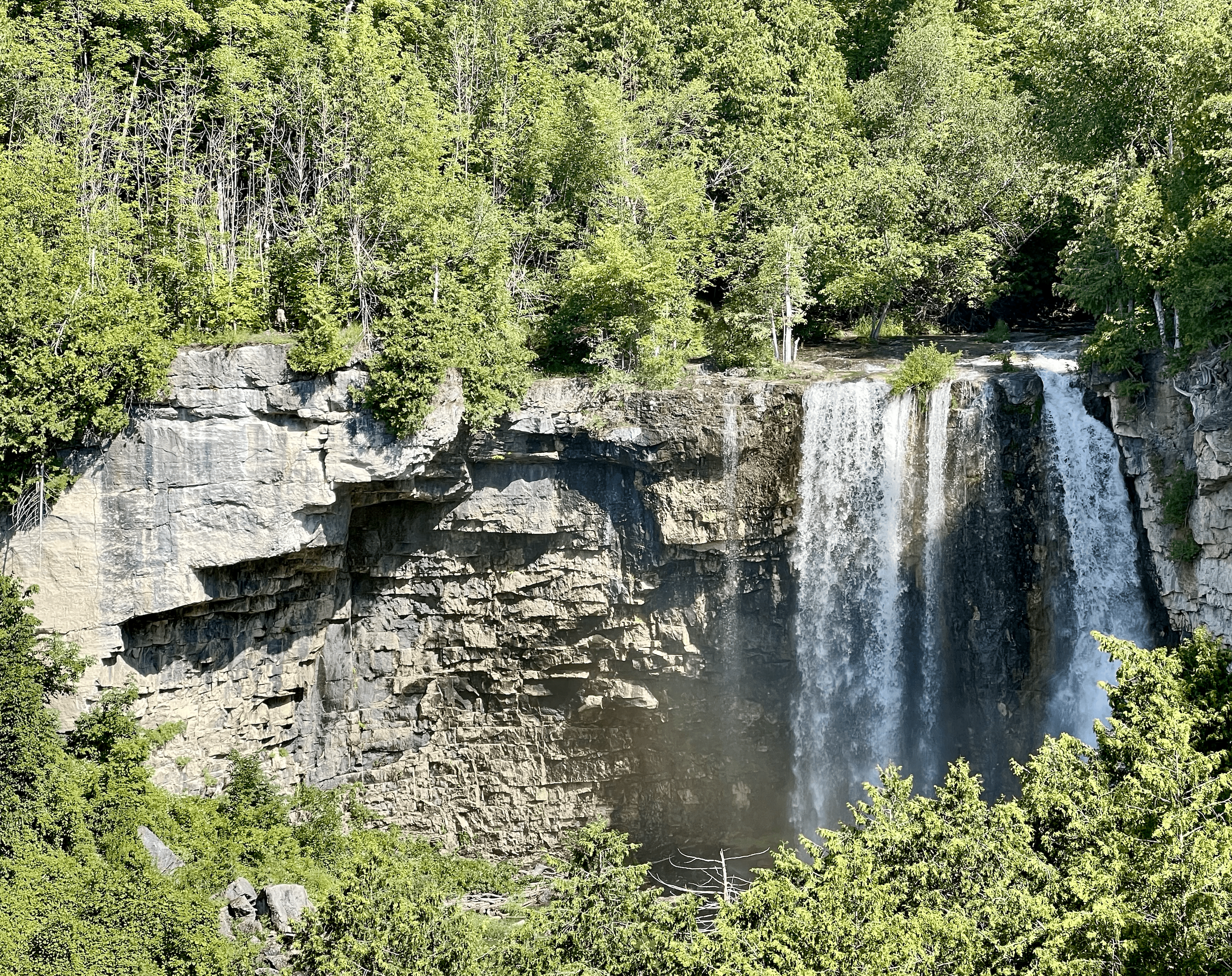
WEDNESDAY WALKERS - Eugenia Falls to Hogg's Fall
https://hikesstaging.brucetrail.org/event/wednesday-walkers-eugenia-falls-to-hoggs-fall/Sorry, the registration cut-off time for this hike has been reached.Not a member? Click here to join today!Hosting Club: Beaver Valley
Location (Google Maps): We will meet in the parking lot of Hogg’s Falls, km 67.5, Map 26, Edition 30. From there we will take the number of vehicles necessary to go to the start of the hike. (Parking at Eugenia Falls CA is paid parking.)
Hike Leader(s): Margaret Yaraskavitch Click here to contact the hike leader.
Pace: Medium
Terrain: Moderate, Some steep sections
Length of Hike: 7 kmDescription
This hike begins with some views of Eugenia Falls, at the crest and through the trees. From there it’s on to the Cuckoo Valley. The beginnings of fall colour may show at the outstanding Cuckoo Valley lookout area. Passing through mature forest and by an upland meadow, we arrive at Hogg’s Falls, an always picturesque scene on the Boyne RiverGood Companions - Spring Valley - Ancaster
https://hikesstaging.brucetrail.org/event/good-companions-spring-valley-ancaster-3/Sorry, the registration cut-off time for this hike has been reached.Not a member? Click here to join today!Hike open to BTC Members only.
Hosting Club: Iroquoia
Category: Good Companions
Location (Google Maps):Ancaster Little League Ball Park – Jerseyville Rd (across from the Ancaster Lions Outdoor Pool) – See map below
Hike Leader(s): Ted Bossence Click here to contact Hike Leader(s)
Pace: Medium – 3 to 4 km/hr
Terrain: Strenuous – Hilly with steep climbs and some poor footing
Distance: 8 – 10 km depending on whether we follow the Headwaters Trail to the end or notDescription
We will follow the Spring Valley Trail, Martins Road, Headwaters Trail etc. in the western part of the Dundas Valley . Bring sunscreen, bug repellant, water and a snack (poles would also be useful). If I cancel due to rain I will notify you by email no later than the night before, so please check your emails before you leave for the hike. Please arrive a few minutes before the 10:00am time since I will be leaving promptly at 10:00.If you need to cancel after the 4:00pm cut-off time, please inform me by email the day before the hike at tedbossence@sympatico.ca , or by text at (905) 334-8752 the morning of the hike.
14:00 Glenridge Quarry Loop
https://hikesstaging.brucetrail.org/event/1400-glenridge-quarry-loop/Sorry, the registration cut-off time for this hike has been reached.Not a member? Click here to join today!Hosting Club: Niagara
Category: Hike
Location (Google Maps): Glenridge Quarry parking lot, St. David’s Rd. Map 3)Hike Leader(s): Larry Lloyd Click here to contact Hike Leader(s)
Pace: Leisurely
Terrain: Easy
Distance: 6 kmDescription
A combination of open trails with spectacular views across Lake Ontario, and wooded trails including the main trail. - 28September 28, 2023
8:00 am Long Hike Jordan to Moyer / Louth
https://hikesstaging.brucetrail.org/event/800-am-long-hike-jordan-to-moyer-louth-60/Sorry, the registration cut-off time for this hike has been reached.Not a member? Click here to join today!Hosting Club: Niagara
Location (Google Maps):
Jordan Hollow Park 3039 King St Jordan
Pace: Medium
Terrain: Moderate
: 10kDescription
From Jordan Hollow Hike the main trail to Upper and Lower Balls Falls, Moyer Road or Louth and Return. You must register for each hike. Bring Poles, sunscreen, bug spray , snack and a drink and dress for the weather
Car Hike: Sydenham End to End 8 of 8
https://hikesstaging.brucetrail.org/event/car-hike-sydenham-end-to-end-8-of-8/Sorry, the registration cut-off time for this hike has been reached.Not a member? Click here to join today!Hike open to BTC Members only.
Hosting Club: Toronto
Category: Car Hike
Location (Google Maps): On this final hike of the Sydenham series, we’ll meet at the Bluewater Park (GPS N44.742514, W81.135140) in Wiarton, where the parking lot is opposite the arena and close to the pool.Hike Leader(s): Jacqueline Van Dyke Click here to contact Hike Leader(s)
Pace: Brisk
Terrain: Hilly, Variable
Distance: 22kmDescription
Wow, it’s Badge Day!!! To purchase a badge, the cost is $10 for BTC members. On this hike, we’ll hike along the well-known Colpoy’s Range Rd (It’s often a place to get very wet feet), have some scenic views, and walk through Oxenden before finishing at Bluewater in Wiarton.Please ensure you arrive prior to 8:15 to be ready for an 8:30 departure. This is a car shuttle hike so please be prepared to share in the shuttling. All Covid protocols will be followed.
Please check the weather the night before/morning of, the hike and dress accordingly. Bring enough water, snacks, and lunch to last the entire hike.
9:15 Short Hike, Jordan Hollow
https://hikesstaging.brucetrail.org/event/915-short-hike-jordan-hollow-76/Sorry, the registration cut-off time for this hike has been reached.Not a member? Click here to join today!Hosting Club: Niagara
Category: Loop
Location (Google Maps): Jordan Hollow Park, Jordan StationHike Leader(s): Bill Russell Click here to contact Hike Leader(s)
Pace: Medium
Terrain: Strenuous
Distance: 6kDescription
Hike the main and side trails around Jordan and Ball’s Falls. Bring hiking boots, water, sunscreen and bug spray.Iroquoia End-to-End Hike 4 of 10
https://hikesstaging.brucetrail.org/event/iroquoia-end-to-end-hike-4-of-10/Sorry, the registration cut-off time for this hike has been reached.Not a member? Click here to join today!Hosting Club: Caledon Hills
Category: End-to-End
Location (Google Maps): Meet at City View Park off of Kerns Rd., km 76.3. Shuttle to start at Mt. Nemo. Paid parking arrangements to be made prior of hike date.Hike Leader(s): Nancy Mooney Click here to contact Hike Leader(s)
Pace: Medium – 3 to 4 km/hour
Terrain: Easy – mostly flat and usually good footing, Moderate – some hills and/or some poor footing
Distance: From 87.3 to 76.9 plus side trail to parking, 10.7 km. Maps 10, 9Description
This is the fourth hike of ten. Beginning with road walking the hike goes through different forests, past Fisher’s Pond, offers views of Lake Ontario and Burlington, passes Signal Hill and through Kerncliff Park.
New Badge! Beaver Valley Geology Hike #2
https://hikesstaging.brucetrail.org/event/new-badge-beaver-valley-geology-hike-2/Sorry, the registration cut-off time for this hike has been reached.Not a member? Click here to join today!Hosting Club: Beaver Valley
Location (Google Maps): Meet on 6th Line, north of Grey Road 119, km 13.7
Hike Leader(s): Glenda Collings Click here to contact the hike leader.
Pace: Medium
Terrain: Moderate, Some rocky footing, Some steep sections
Length of Hike: 4.3 kmDescription
This is a series of 7 hikes to earn the Beaver Valley Geology badge. We will use the criteria listed in Beth Gilhespy’s book, Walking Through Time, Exploring Niagara Escarpment Geology in the Beaver Valley Bruce Trail Section. We’ll boost our knowledge of the local geology along the way as we take the required photos. Hikers are welcome to join any or all of the hikes, however, they must complete all 7 hikes to earn the badge. Bring sufficient water and snacks.Hike Two: Margaret Paull Side Trail
COVID-19 Precautions Before, During and After your Hike
- Each hiker joining a Bruce Trail Club organized hike must perform a self-screening check before hiking.
Find Ontario’s self-assessment tool here: https://covid-19.ontario.ca/self-assessment/ - If you are experiencing COVID-19 symptoms, stay home.
- Personal Protective Equipment:
- Hikers may choose to wear masks
Transportation
It is the Bruce Trail Conservancy’s current policy that car shuttles are allowed. It is at the discrepancy of individual hike leaders to make that decision.
Other Guidelines
- Arrive 15 minutes before the start of the hike.
- Wear sturdy footwear and appropriate attire for the weather and the terrain.
Hiking poles are a good idea in any season, especially if the terrain is rocky or slippery. In winter, snowshoes or icers/crampons are needed when conditions dictate.
Wearing appropriate clothing and footwear prevents injuries and shows consideration for a safe and positive group hiking experience. - Always carry I.D. and your health card.
- Bring sufficient water and snacks (or lunch if indicated). A minimum of 1L of water is recommended on all hikes, and 3L is recommended for long, challenging hikes in the heat of the summer.
- Bring sunscreen and insect repellent (for spring and summer hikes).
- Bring your own first aid kit.
- Please leave dogs at home.
Mt. Nemo CA to Kilbride Public School, Map 10
https://hikesstaging.brucetrail.org/event/mt-nemo-ca-to-kilbride-public-school-map-10-3/Sorry, the registration cut-off time for this hike has been reached.Not a member? Click here to join today!Hosting Club: Iroquoia
Category: Thursday Group
Location (Google Maps):Meet at the back of Kilbride Public School (by park and tennis courts). 6611 Panton St. (just off Kilbride st). Will be a shuttle to the Walker Line access to Mt. Nemo CA
Hike Leader(s): Karen Capindale-Smith Click here to contact Hike Leader(s)
Pace: Medium – 3 to 4 km/hr
Terrain: Strenuous – Hilly with steep climbs and some poor footing
Distance: 12 kmDescription
We will shuttle to Walkers Line access of Mt Nemo CA and follow main BT up escarpment into Conservation Area ( for lovely views of the countryside and hopefully some fall colours) and out along rural roads. We will continue on into Bronte Creek/Cedar Springs Valley. We will finish our hike climbing a strenuous stretch out of the valley and into the village of Kilbride. Driver(s) will be needed to drive back to starting point to recover shuttle car(s). Bring water, snacks, lunch and appropriate clothing layers for the weather. Drivers with Conservation pass may need a reservation to access the Mt Nemo CA parking lot.
Hike Leader: Karen Capindale-Smith; kjcapindale@gmail.com; hike morning use cell (905) 749-0914.
Baked goods can be expected 🙂
- Each hiker joining a Bruce Trail Club organized hike must perform a self-screening check before hiking.