
Hike Schedule
Join us for a hike! Registration required.
All hikes available to BTC members. Some hikes are open to non-members.
See Refund Policy for Paid Hikes >
TIP: The calendar view displays up to 7 hikes on a day, but often there are more. Click “View more events” to see them all.
Categories
- 16April 16, 2023
Fort to Fort SECOND DAY ONLY April, 16, 2023
https://hikesstaging.brucetrail.org/event/fort-to-fort-second-day-only-april-16-2023/Sorry, the registration cut-off time for this hike has been reached.Not a member? Click here to join today!Hosting Club: Niagara
Category: Event Hikes
Location (Google Maps):Kingsbridge Park, Chippawa, Ontario
Pace: Medium
Terrain: Easy
Distance: 27kmDescription
This is a self led hike
Meet at Kingsbridge Park at 6:45. You will be bussed to Old Fort Erie. Hike back to Kingsbridge Park from Old Fort Erie, approximately 27KM. Terrain is flat with mostly paved paths. 2 checkpoints along the way.Masks are optional on buses.
Registration is $50. (members) , $60 (non-members) for 1 day. Fee includes bus and checkpoints .
Event Co-ordinator: Lauren Doig, ldoig52@gmail.com

Youth Hike at St. John's Conservation Area (Ages 18-25 only)
https://hikesstaging.brucetrail.org/event/youth-hike-at-st-johns-conservation-area-ages-18-25-only/Sorry, the registration cut-off time for this hike has been reached.Not a member? Click here to join today!Hosting Club: Niagara
Category: Youth Hike
Location (Google Maps): St. John’s Conservation Area parking lotHike Leader(s): Nolan Repovs Click here to contact Hike Leader(s)
Pace: Leisurely
Terrain: Moderate
Distance: 2 kmDescription
Ages 18-25 onlyA great chance to connect with like minded young people, and possibly network, or just enjoy the hike.
Might be sprinkling
Migration Monitor Hike
https://hikesstaging.brucetrail.org/event/migration-monitor-hike-6/Sorry, the registration cut-off time for this hike has been reached.Not a member? Click here to join today!Hosting Club: Peninsula
Location (Google Maps): Parking for all hikes start at km 109.7, 30th Ed Ref Manual. Park adjacent to Cape Chin Mail boxes on Cape Chin North Road
Hike1 (Mar 12, 26, Apr 9): Otter Lake/Cape Chin Loop – see details below
Hike 2 (Mar 19, Apr 2, Apr 16): Borchardt/Cotrill Lk Loop – see details belowHike Leader(s): Tamara Wilson Click here to contact Hike Leader(s)
Pace: Leisurely
Terrain: Difficult
Distance: Each hike ranges 10 to 12 kmDescription
Join us as we look for clues of spring’s arrival on Cape Chin North. We will alternate two routes on a weekly basis, watching for seasonal changes along the wetlands, small inland lakes, woodlands and escarpment shoreline. We will stop, look and listen for the arrival of plants and flowers, birds and other harbingers of spring. Hikes are weather dependent and will be cancelled for treacherous local driving conditions (mud), rain, snow or very strong winds. Always check the road and weather conditions for the entire length of your trip up as local weather can be quite different. Some hikes may recommend snow shoe hikes (I will let you know). Poles and crampons are recommended for navigating wet and slippery conditions typical of spring hikes. It is recommended to bring snacks and water for the hike. A dry set of socks and shoes is a good idea for the trip home. A sweep, topic experts – all are welcome!Alternating hikes:
Hike1 (Mar 12, 26, Apr 9): From km 109.7 parking, Otter Lk ST (2.2 km), up Cape Chin N Rd (past Tagwerk) to Cape Chin Meadow ST (1km) to Cape Chin Driveway (2.5 km) to house, North along MT back to parked vehicles (3.6 km ) – Total 9.3 km approx
Hike 2: (Mar 19, Apr 2, Apr 16) – From km 109.7 parking, MT North through Cape Chin Woods to Borchardt Parking (2.3 km), Minhinnik ST (1.7km) to Lillie Parking Lot, Take Cotrill Lk ST (1.4km) to Anne and Clayton Robert’s St (turn right) back to Britain Lk Rd (1km). At this point we will either a) follow Britain Lk Rd and reverse the route that we took (Minhinnik to Borchardt back along Borchardt to parking) – approx 12km OR b) if conditions are good, we will follow the Main Trail back along the escarpment to Borchardt PL and hike back to the vehicles along Borchardt.
Sunday Social Hike - Woodford Escarpment Side Trail
https://hikesstaging.brucetrail.org/event/woodford-escarpment-side-trail/Sorry, the registration cut-off time for this hike has been reached.Not a member? Click here to join today!Hosting Club: Sydenham
Category: General Hike
Location (Google Maps): Meet in the north-east corner of the parking lot at Home Depot on Highway 26 on the east side of Owen Sound.Hike Leader(s): Ian Mills Click here to contact Hike Leader(s)
Pace: Leisurely: 3 km/h or less
Terrain: Moderate: Some hills and/or poor footing, There might be muddy sections., There might be sections with water on the trail.
Distance: 3.5 or 5 kmsDescription
Starting at the Woodford Community Centre 41.7 Km (Map 30), along the Woodford Escarpment Side Trail returning via the Main Trail. After completing we could decide to do the Crevice Springs Side Trail returning to the starting point via the the Main Trail. If you are unable to register, please call or text Ian Mills @ 416-848-8818. - 17April 17, 2023
Car Hike: Dufferin End to End 3 of 3
https://hikesstaging.brucetrail.org/event/car-hike-dufferin-end-to-end-3-of-3/Sorry, the registration cut-off time for this hike has been reached.Not a member? Click here to join today!Hike open to BTC Members only.
Hosting Club: Toronto
Category: Car Hike
Location (Google Maps): Roadside parking at km 55.7 (GPS N44.268777, W80.156810), on Mulmur-Nottawasaga Townline, 550 east of Lavendar Hill Rd., at the cemetery. DO NOT BLOCK CEMETERY GATE. Follow parking instructions on the sign at the cemetery.Hike Leader(s): Jacqueline Van Dyke Click here to contact Hike Leader(s)
Pace: Brisk
Terrain: Hilly, Variable
Distance: 19kmDescription
Badge day for those who have completed the Dufferin section! Cost for BTC members is $10. On this hike, we’ll pass through forests and fields, and enjoy views to the northwest of some of the richest farmland in Ontario (Honeywood Loam).Please arrive prior to 8:15 to be ready for an 8:30 departure. This is a car shuttle hike so be prepared to share equally in the shuttling.
Check the weather forecast the night before/morning of, the hike and dress accordingly. Bring enough water, snacks, and lunch to last the entire hike. Gaitors and icers may be helpful to combat the mud we will most likely encounter.
Toronto end to end 3 of 3
https://hikesstaging.brucetrail.org/event/toronto-end-to-end-3-of-3/Sorry, the registration cut-off time for this hike has been reached.Not a member? Click here to join today!Hosting Club: Niagara
Category: Car Pool
Location (Google Maps): Meet at Boston Mill Rd. (km 48.3) West of Mississauga rd. carpool to Eight Line and 27 Side Rd.Hike Leader(s): Vince Zvonar Click here to contact Hike Leader(s)
Pace: Brisk
Terrain: Moderate
Distance: 16.4Description

Crawford Lake Halton Conservation
https://hikesstaging.brucetrail.org/event/crawford-lake-halton-conservation/Sorry, the registration cut-off time for this hike has been reached.Not a member? Click here to join today!Hosting Club: Iroquoia
Category: General Hike
Location (Google Maps): Crawford Lake Conservation AreaHike Leader(s): Bronwen Tregunno Click here to contact Hike Leader(s)
Pace: Leisurely – 3km/hr or less
Terrain: Moderate – Some hills and/or some poor footing
Distance: 5kmDescription
A gentle spring walk that takes us through Bruce Trail side loop and along the escarpment and lookout. Registration required on Halton Conservation Crawford Lake site https://www.conservationhalton.ca/parks/crawford-lake/ Paid entrance. Please bring snack, water and personal first aid. Poles helpful. Rocks can be wet we will take it slow if it’s rained. Cancelled in inclement weather. Meet at lower parking lot. - 18April 18, 2023
9:00 Long Hike Rockway
https://hikesstaging.brucetrail.org/event/900-long-hike-rockway-3/Sorry, the registration cut-off time for this hike has been reached.Not a member? Click here to join today!Hosting Club: Niagara
Location (Google Maps): Rockway Community Center
Hike Leader(s): Alan Laver Click here to contact Hike Leader(s)
Pace: Medium
Terrain: Moderate
Distance: 10kmDescription
Explore Rockway and Louth Conservation area Register for each hike
Bring Poles water, snack and Dress for the weather, Icers and layers/p>
9:15 Short hike - Rotary Park, St. Catharines
https://hikesstaging.brucetrail.org/event/915-short-hike-rotary-park-st-catharines-7/Sorry, the registration cut-off time for this hike has been reached.Not a member? Click here to join today!Hosting Club: Niagara
Category: In and Out
Location (Google Maps): Rotary Park, St. CatharinesHike Leader(s): janet davey Click here to contact Hike Leader(s)
Pace: Medium
Terrain: Moderate
Distance: 6kmDescription
Hike the trails in Rotary Park. Bring hiking boots and water.
Noisy River Provincial Nature Reserve
https://hikesstaging.brucetrail.org/event/noisy-river-provincial-nature-reserve-3/Sorry, the registration cut-off time for this hike has been reached.Not a member? Click here to join today!Hosting Club: Dufferin Hi-Land
Category: Tuesday Hike
Location (Google Maps): (Google Maps) Blue Mountain Section, Map 21. Noisy River Provincial Nature Reserve, Lavender. Roadside parking at km 55.7 on Mulmur-Nottawasaga Townline, 550 meters east of Lavender Hill Road at the cemetery. We will meet at the SuperBurger parking lot (north-west corner of Hwy 89/Hwy 10 intersection) for car pooling at 8:30 am. Otherwise meet at the cemetery parking area 550 meters east of Lavender Hill Road for a 9:30 am start.Hike Leader(s): Tony Evangelista, Les Babbage, Inge Eckerick, Julie Daley Click here to contact Hike Leader(s)
Pace: Medium
Terrain: Moderate, Slippery and Steep Sections
Distance: Long Hike 12 km Short hike 6 kmDescription
From the roadside parking at the Lavender cemetery, we will hike through the small town of Lavender. This marks the end of the Dufferin Hi-Land Section and the beginning of the Blue Mountain section. Then we will hike north to enter the nature reserve. The trail wanders in and out of woods and pasture land to the escarpment edge and scenic lookout. After continuing on the trail for about 6 km, we will turn around and return to the parking area. Those choosing to do a shorter hike can turn around and return to the parking area after 3 km.Bring water, lunch and snacks. Hiking poles are recommended.
Sawmill Valley-Credit River
https://hikesstaging.brucetrail.org/event/sawmill-valley-credit-river-2/Sorry, the registration cut-off time for this hike has been reached.Not a member? Click here to join today!Hosting Club: Caledon Hills
Category: Car Hike
Location (Google Maps):Erindale Park, 1695 Dundas St West. — From QEW take Erin Mills Parkway north to Dundas St. Turn right and after about one km (just after passing lights at Mississauga Rd) turn left into Erindale Park. From Hwy 401 or 403 come south on Erin Mills Pkwy to Dundas and turn left. Note: The exit from 401 is called “Mississauga Rd”. Two km south of 401 Mississauga Rd goes to the left but keep right to stay on “Erin Mills Pkwy”.
Hike Leader(s): Peter Leeney, cell phone 905-301-4091 Click here to contact Hike Leader(s)
Pace: Moderate
Terrain: Flat
Distance: 11 km loopDescription
An urban walk from Erindale Park up the Sawmill Valley Trail then across on Burnhamthorpe Rd. to the Credit River (Culham Trail) and return to Erindale Park.CANCELLED Walter's Falls Loop
https://hikesstaging.brucetrail.org/event/walters-falls-loop-2/Sorry, the registration cut-off time for this hike has been reached.Not a member? Click here to join today!Hosting Club: Sydenham
Category: General Hike
Location (Google Maps): Roadside Parking on the east shoulder of St Vincent-Sydenham Townline, north of Holland-Sydenham Townline at km 7.4 (Map 29)Hike Leader(s): Fran Turner Click here to contact Hike Leader(s)
Pace: Brisk: 4 to 5 km/h
Terrain: Strenuous: Hilly with steep climbs and some poor footing.
Distance: 8.5 kmDescription
We’ll take a brisk hike through the Walter’s Falls Management Area, then follow the Walter’s Falls Side Trail where we will enjoy Walter’s Creek from both banks, and stop to admire the impressive waterfall. We’ll retrace our steps through the Management Area back to the cars. There are several steep hills on this hike so both good footwear and fitness are recommended. If you are unable to register, please call or text the leader at 519-590-0706.
Car Hike: A Focus on Forest Ecosystems
https://hikesstaging.brucetrail.org/event/car-hike-a-focus-on-forest-ecosystems/Sorry, the registration cut-off time for this hike has been reached.Not a member? Click here to join today!Hosting Club: Toronto
Category: Car Hike
Location (Google Maps): Meet at the (roadside) parking area at the end of 17 Sideroad, 730 m northeast of Halton Rd 25. Map 12.Hike Leader(s): Janet Patterson Click here to contact Hike Leader(s)
Pace: Leisurely
Terrain: Variable
Distance: approximately 2 or 3 kDescription
As we walk along the trail, we’ll stop frequently to observe and discuss the trees in the forest. Rather than focusing on merely identifying the trees, we will learn about their life cycle, how various species of wildlife depend on them, what their life expectancy is, how indigenous peoples use them (past and present), what threatens them, and more. Our expert guide will be Adam Brylowski, an ecologist on staff at the BTC.
Along with your curiosity, please bring along water and snacks/lunch. Please note that the end time and distance we’ll travel are estimates, depending on weather and trail conditions. Leader is planning to be finished exploring by 2:30 p.m.
This hike is brought to you by the TBTC’s Biodiversity Team. We endeavour to promote the critical role we can all play in protecting and conserving the Niagara Escarpment.
- 19April 19, 2023
Headwaters Dundas Valley
https://hikesstaging.brucetrail.org/event/headwaters-dundas-valley-2/Sorry, the registration cut-off time for this hike has been reached.Not a member? Click here to join today!Hosting Club: Iroquoia
Category: Hikers R Us
Location (Google Maps):Main parking lot for the Dundas Valley Trail Centre
N43.248410 W79.993747Hike Leader(s): Wayne Riley Click here to contact Hike Leader(s)
Pace: Medium – 3 to 4 km/hr
Terrain: Moderate – Some hills and/or some poor footing, Slippery Sections Likely
Distance: 14 to 16 kDescription
We will meet at the Dundas Valley Trail Centre parking lot (entry fee required) and start out on the main trail. We will then take the Headwaters trail and return to the main parking lot. The base hike will be 14k with the possible addition of side trails for 2k moreBring lunch, water, hiking boots and no dogs please.
RSVP using the BTC website.
Cancellations the morning of the hike please call 289 456 3498
please note: there is a fee at the gate for parking unless you have a pass

Beaver Valley End to End in 8 - Guest hike leader Jacquie Van Dyke, Toronto Bruce Trail CLub
https://hikesstaging.brucetrail.org/event/beaver-valley-end-to-end-in-8-guest-hike-leader-jacquie-van-dyke-toronto-bruce-trail-club/Sorry, the registration cut-off time for this hike has been reached.Not a member? Click here to join today!Hike open to BTC Members only.
This is a Multi-Day Hike
You are signing up for the following dates and times:
2023-04-19 at 09:00
2023-04-20 at
2023-04-26 at
2023-04-27 at
2023-05-17 at
2023-05-18 at
2023-05-24 at
2023-05-25 atHosting Club: Beaver Valley
Location (Google Maps): The first hike will meet at km13.7 on the West side of 6th Line, North of Grey 119. Do not block driveways/laneways! We will shuttle to km 00.0 at Maple Lane.
Map 24 Edition 30Hike Leader(s): Beaver Valley Hike Moderator Click here to contact the hike leader.
Pace: Medium
Terrain: Moderate, Some rocky footing, Some steep sections, Strenuous
Length of Hike: 13.7 kmDescription
Participants will earn this badge by hiking all 8 hikes in this series. As life sometimes can be interrupted you may need to miss a hike. You can make up two hikes on your own and still qualify for the badge on the final day. Please keep a log of the made up hikes and email it to the hike leader by the last day.The fee includes the badge and as a fundraiser, also goes towards supporting the Beaver Valley Bruce Trail Club, which in turn supports the mission of the Bruce Trail Conservancy, which is: “Preserving a ribbon of wilderness, for everyone, forever.” Thank you for your support! Please note there are no refunds!
For the time being, registration for the Beaver Valley E2E in 8 will be limited to members of the Bruce Trail Conservancy. Hikers can belong to any section.
This particular set of 8 hikes is intended to be MEDIUM (3 km to 4 km/hour) Before registering, please be honest with yourself about your ability to complete these approximately 15 km, sometimes rugged, hilly, technical hikes.
All hikes in this series will include a car shuttle and everyone should be prepared take a turn as a shuttle driver. Hikers will wear masks in shuttle cars. Trails will be wet at this time of year so please be prepared with extra socks and gaiters. Ideally we will hike from km 0 to km 119.9 over the series of 8 hikes but as conditions change and parking issues arise we ask that you be flexible with changes in the routes and parking. You will receive an e-mail outlining meeting location and start location for each hike as well as any other information needed, closer to the start of the hike event.
We will have a clothing adjustment break, and 2 snack/lunch breaks of 10 min each. Please have your water accessible while hiking. There will be plenty of opportunity for quick photos. We recommend having your camera/phone accessible to get all those great shots.
Please read the hike guidelines below.
Guidelines
- Arrive 15 minutes before the start of the hike.
- Wear sturdy footwear and appropriate attire for the weather and the terrain.
Hiking poles are a good idea in any season, especially if the terrain is rocky or slippery. In winter, snowshoes or icers/crampons are needed when conditions dictate.
Wearing appropriate clothing and footwear prevents injuries and shows consideration for a safe and positive group hiking experience. - Always carry I.D. and your health card.
- Bring sufficient water and snacks (or lunch if indicated). A minimum of 1L of water is recommended on all hikes, and 3L is recommended for long, challenging hikes in the heat of the summer.
- Bring sunscreen and insect repellent (for spring and summer hikes).
- Bring your own first aid kit.
- Please leave dogs at home.
COVID-19 Precautions before and during the hike
Each hiker joining a Bruce Trail Club organized hike must perform a self-screening
before the hike. Find Ontario’s self-assessment tool here:
https://covid-19.ontario.ca/self-assessment/ If you are experiencing COVID-19
symptoms, stay home.
Personal Protective Equipment: Hikers may choose to wear masks.
** CANCELLED Old Baldy
https://hikesstaging.brucetrail.org/event/old-baldy-6/Sorry, the registration cut-off time for this hike has been reached.Not a member? Click here to join today!Hosting Club: Blue Mountains
Category: Cancelled
Location (Google Maps): Hike meets in the parking lot behind Tim Hortons on First St. in Collingwood.Hike Leader(s): Jennifer Roy Click here to contact Hike Leader(s)
Pace: Medium – 3 to 4 km/hr
Terrain: Moderate – Some hills and/or some poor footing
Distance: 5kmDescription
We will park at km 46.8 on Cty. Rd. 13 in the Beaver Valley section and hike up the escarpment on the white blazed trail to Old Baldy and Mac Kirk Side Trail. This is a lollipop hike. The trail passes lookouts and you can birdwatch for turkey vultures and buteo hawks. Bring water and a snack. Map 26 Edition 30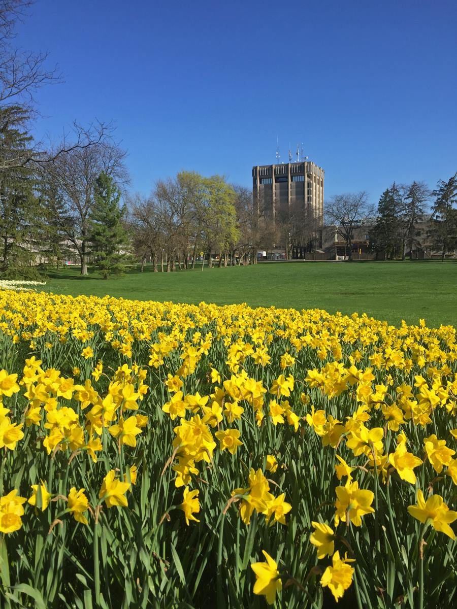
9:15 Brock Daffodil Hunt
https://hikesstaging.brucetrail.org/event/915-brock-daffodil-hunt/Sorry, the registration cut-off time for this hike has been reached.Not a member? Click here to join today!Hosting Club: Niagara
Category: Loop
Location (Google Maps): Glenridge Quarry Naturalization Site, off St. David’s Rd and east of Glenridge Ave.Hike Leader(s): Karen Couch Click here to contact Hike Leader(s)
Pace: Medium
Terrain: Moderate
Distance: 7.5 kmsDescription
Hike around the Glenridge Quarry site to join the main trail around Brock University. Hopefully the daffodils will be in bloom and we can see how the cherry blossoms are progressing on the university grounds. The attached image is from 2017 so we’ll see how and/or if things have changed. Please note: Come prepared for mud on some of the trail.
Biodiversity Spring Nature Walk: 2nd Annual Pools, Ponds & Peepers
https://hikesstaging.brucetrail.org/event/2nd-annual-pools-ponds-peepers/Sorry, the registration cut-off time for this hike has been reached.Not a member? Click here to join today!Hosting Club: Caledon Hills
Category: Nature Walks
Location (Google Maps): Location: Meet at roadside parking at the dead end of Boston Mills Rd., about 400 m west of Mississauga Rd.Directions: From Hwy 10 take Boston Mills Rd. 6 km west to the dead end just west of Mississauga Rd. An alternative is to take Mississauga Rd. north from King St. about 3 kms, turn left on Boston Mills Rd. for about 400 m
Hike Leader(s): Richard Smythe Click here to contact Hike Leader(s)
Pace: Leisurely – 3 km/hour or less
Terrain: Moderate – some hills and/or some poor footing
Distance: 3.8 kilometresDescription
There and back on both the Main Trail and the Rockside Side Trail, about 3.8 kms, with some hills and rugged sections. Hiking poles can be a great help. The pace will be slow at times with numerous stops to observe the spring ephemerals, listen to bird song and take photos. Bring your binoculars, camera and cellphone. Apps like Merlin, Seek, and iNaturalist will help identify flora and fauna along the route.Good Companions - Shell Park and Bronte Trails
https://hikesstaging.brucetrail.org/event/good-companions-shell-park-and-bronte-trails-3/Sorry, the registration cut-off time for this hike has been reached.Not a member? Click here to join today!Hike open to BTC Members only.
Hosting Club: Iroquoia
Category: Good Companions
Location (Google Maps):Shell Park, Lakeshore Road, Bronte (parking lot closest to Lakeshore Road) See map below
Hike Leader(s): Ted Bossence Click here to contact Hike Leader(s)
Pace: Medium – 3 to 4 km/hr
Terrain: Easy – Mostly flat and usually good footing
Distance: 7.5 kmDescription
We will hike through Shell Park and trails in Bronte to Bronte Creek and Bronte Harbour, returning via the lake and pioneer cemetery. Bring water and a snack. Please arrive a few minutes before the start time, I will be leaving on time. If you are unable to come and cancel after 4:00 pm on the day before the hike, please let me know by email that evening (tedbossence@sympatico.ca) or by text the next morning (905 334-8752).